photo free
Home Images Vectors Videos

Stock image Aerial view of deforestation area for agricultural land by drone. Contact zone between forest and plantation

Stock image Aerial view of deforestation area for agricultural land by drone. Contact zone between forest and plantation
Published: Nov.10, 2020 12:39:50
Author: salajean
Views: 4
Downloads: 3
File type: image / jpg
File size: 20.62 MB
Orginal size: 5464 x 3640 px
Available sizes:
S
(500 x 333)
M
(1000 x 666)
L
(2000 x 1332)
XL
(5464 x 3640)
EL0
(5464 x 3640)
Level: silver
Download Image
Image topics:

Similar stock images

stock image Aerial view from drone top view. Aerial view amazing over railwa

Aerial View From Drone Top View. Aerial View Amazing Over Railwa

5464 × 3640
stock image autumn forest - birch - view from above

Autumn Forest - Birch - View From Above

5464 × 3640
stock image Aerial above view of autumn forest. Drone shot of trees canopy

Aerial Above View Of Autumn Forest. Drone Shot Of Trees Canopy

4600 × 3064
stock image Aerial view of deforestation area for agricultural land by drone. Contact zone between forest and plantation

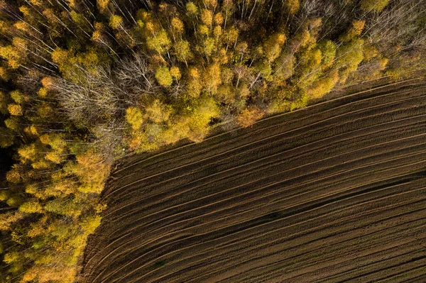
Aerial View Of Deforestation Area For Agricultural Land By Drone. Contact Zone Between Forest And Plantation

5464 × 3640
stock image Autumn landscape of Tuscany and space for your decorations, products or text. Fall time and mood colors.

Autumn Landscape Of Tuscany And Space For Your Decorations, Products Or Text. Fall Time And Mood Colors.

5464 × 3640
stock image Aerial view of canopy of birch tree forest. Above drone view

Aerial View Of Canopy Of Birch Tree Forest. Above Drone View

5464 × 3640