Home
Images
Vectors
Videos
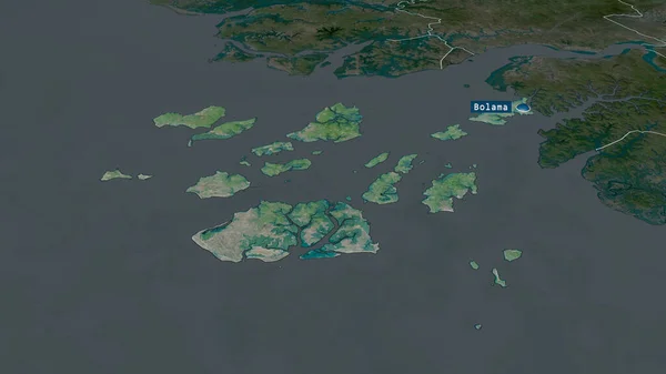
Stock image Bolama - region of Guinea-Bissau zoomed and highlighted with capital. Satellite imagery. 3D rendering
Published:
Jun.26, 2020 07:44:39
Author:
Yarr65
Views:
0
Downloads:
0
File type:
image
/
jpg
File size:
1.98 MB
Orginal size:
2880
x
1620
px
Available sizes:
S
(500 x 281)
M
(1000 x 563)
L
(2000 x 1125)
XL
(2880 x 1620)
EL0
(2880 x 1620)
Level:
bronze
Download Image
Image topics:
View
Shape
Travel
Nature
Sea
Border
Landscape
Glow
Earth
Planet
World
Ocean
Science
Capital
Globe
Profile
Outline
Country
Map
Cartography
Geography
Africa
Continent
Land
Zoom
Satellite
Region
Territory
Atlas
Overlay
Bissau
Guinea Bissau
3d Rendering
Subregion
Bolama
Gnb
Administrative Division
Bolama Bijagcs
Highlighted With Capital
Similar stock images
Bolama - Region Of Guinea-Bissau Zoomed And Highlighted. Satellite Imagery. 3D Rendering
2880 × 1620
Zoom In On Phuket (province Of Thailand) Outlined. Oblique Perspective. Topographic Relief Map With Surface Waters. 3D Rendering
3840 × 2160
Zoom In On Kepulauan Riau (province Of Indonesia) Outlined. Oblique Perspective. Topographic Relief Map With Surface Waters. 3D Rendering
3840 × 2160
The Highlighted Area Of Galapagos Islands With Capital Point On The Desaturated Map Of Its Neighbourhood. Color Map Of The Administrative Division
2880 × 1620
Zoom In On Jeollanam-do (province Of South Korea) Extruded. Oblique Perspective. Colored And Bumped Map Of The Administrative Division With Surface Waters. 3D Rendering
3840 × 2160
Zoom In On Bolama (region Of Guinea-Bissau) Outlined. Oblique Perspective. Colored And Bumped Map Of The Administrative Division With Surface Waters. 3D Rendering
3840 × 2160
Zoom In On Vesturland (region Of Iceland) Extruded. Oblique Perspective. Colored And Bumped Map Of The Administrative Division With Surface Waters. 3D Rendering
3840 × 2160
The Highlighted Area Of Faroe Islands With Capital Point And Label On The Desaturated Map Of Its Neighbourhood. Color Physical Map
2880 × 1620