Home
Images
Vectors
Videos
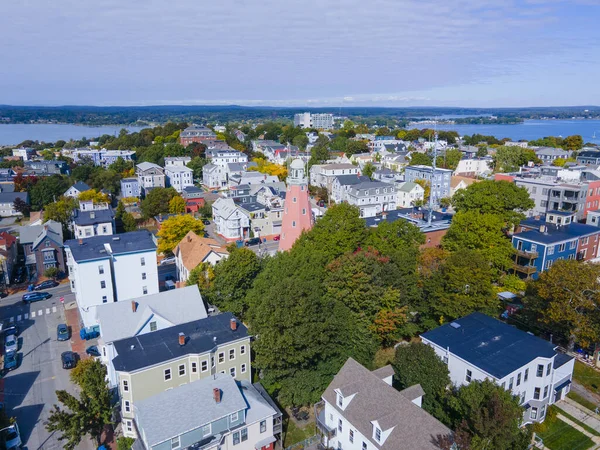
Stock image Portland Harbor and mouth of the Fore River panoramic aerial view from East End of Portland, Maine ME, USA.
Published:
Oct.18, 2021 13:11:54
Author:
jiawangkun
Views:
4
Downloads:
0
File type:
image
/
jpg
File size:
8.68 MB
Orginal size:
4000
x
3000
px
Available sizes:
S
(500 x 375)
M
(1000 x 750)
L
(2000 x 1500)
XL
(4000 x 3000)
EL0
(4000 x 3000)
Level:
bronze
Download Image
Image topics:
View
Travel
Scene
Nature
Water
Natural
Mouth
Sea
End
River
Landscape
Architecture
Building
City
House
American
Usa
Bay
Beach
Coast
Coastline
Ocean
Shore
Tourism
Panorama
Landmark
Town
Harbor
Panoramic
East
Historic
History
Tourist
Seashore
Historical
Tour
America
Atlantic
Aerial
United
States
Cove
Portland
Maine
Shoreline
Fore
Me
Seafront
Oceanfront
Drone
Similar stock images
North River And Danvers River Aerial View At The River Mouth To The Atlantic At Salem Neck Historic District In City Of Salem, Massachusetts MA, USA.
8000 × 6000
Aerial View Of Portland Historic Downtown Skyline On Congress Street, Viewed From Munjoy Hill, Portland, Maine ME, USA.
4000 × 3000
Aerial View Of Portland Historic Downtown Skyline On Congress Street, Viewed From Munjoy Hill, Portland, Maine ME, USA.
4000 × 3000
North River And Danvers River Aerial View At The River Mouth To The Atlantic At Salem Neck Historic District In City Of Salem, Massachusetts MA, USA.
8000 × 6000
Portland Observatory Aerial View At 138 Congress Street On Munjoy Hill In Portland, Maine ME, USA. This Observatory Is A Historic Maritime Signal Tower Built In 1807.
4000 × 3000
Aerial View Of Savannah Skyline From City Center, Georgia, USA
3072 × 1728
Wakefield Historic Town Center Aerial View On Main Street In Wakefield, Massachusetts MA, USA.
3992 × 2992
Bar Harbor Historic Town Center Aerial View On Main Street, Bar Harbor, Maine ME, USA.
4000 × 3000