Home
Images
Vectors
Videos
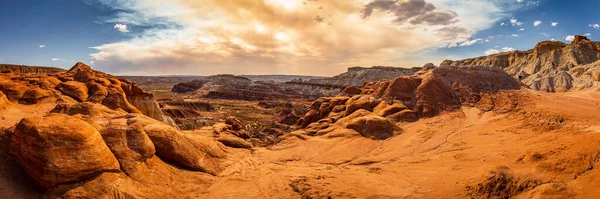
Stock image The Toadstool Trail leads to an area of hoodoos and balanced rock formations created by centuries of erosion and is part of the Grand Staircase-Escalante National Monument in Kane County, Utah.
Published:
Oct.20, 2020 11:48:13
Author:
adifferentbrian
Views:
0
Downloads:
0
File type:
image
/
jpg
File size:
19.99 MB
Orginal size:
18267
x
6089
px
Available sizes:
S
(500 x 167)
M
(1000 x 333)
L
(2000 x 667)
XL
(18267 x 6089)
EL0
(18267 x 6089)
Level:
bronze
Download Image
Image topics:
Stone
Travel
Outdoors
Nature
Texture
Landscape
Usa
Rock
Scenic
Tourism
Page
Dry
Hiking
Monument
Geology
Desert
Arizona
Formation
Staircase
Toadstool
Sandstone
Arid
Eroded
Erosion
Canyon
Formations
Cliffs
Southwest
Utah
Hoodoos
Hoodoo
Escalante
National Monument
Rock Formation
Road Trip
Grand Staircase Escalante
Desert Landscape
Geological Features
Entrada Sandstone
Kane County
Toadstool Trail
The Toadstools
Dakota Formation
Toadstools Trail
Toadstool Hoodoo
Similar stock images
Vermilion Cliffs National Monument. Landscapes At Sunrise. Unusual Mountains Landscape. Beautiful Natural Background.
5648 × 3784
Panorama Of Arches National Park
3879 × 2571
The Colorful Red, Yellow And White Sandstone Rock Formations Along The White Dome Trail In The Valley Of Fire State Park In Nevada, USA
10813 × 3069
Bryce Canyon National Park Nature Landscape In Utah, USA
3000 × 1688
Bryce Canyon National Park
7360 × 4912
Sandstone Formations In Utah, USA. Yant Flats
5520 × 3808
A Panoramic High Angle View Of The Crimson-colored Hoodoos Under The Cloudy Sky In The Bryce Canyon National Park, Utah, USA
8193 × 2818
Mesa Arch, Canyonlands National Park, Utah, USA
15997 × 3864