Home
Images
Vectors
Videos
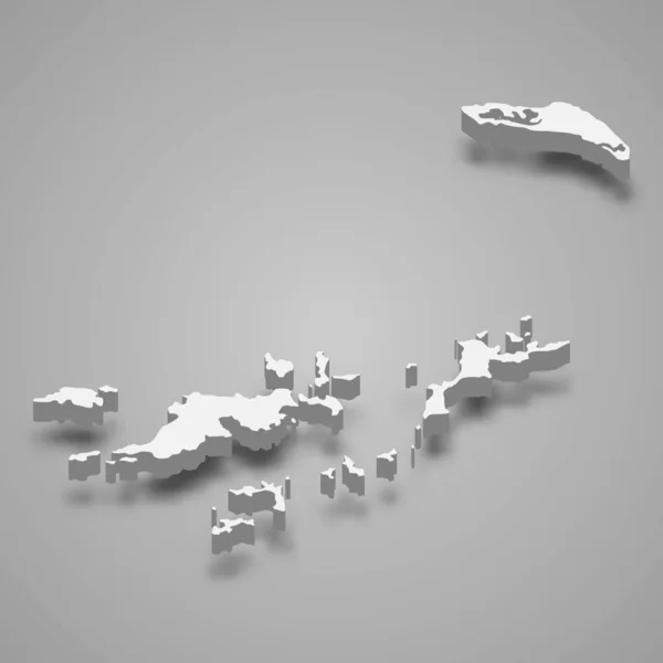
Stock vector 3d isometric map of Shetland Islands is a region of Scotland, vector illustration
Published:
May.06, 2021 07:44:11
Author:
grebeshkovmaxim@gmail.com
Views:
19
Downloads:
1
File type:
vector
/
eps
File size:
18.97 MB
Orginal size:
4000
x
4000
px
Available sizes:
S
(500 x 500)
M
(1000 x 1000)
L
(2000 x 2000)
XL
(4000 x 4000)
VECT
(4000 x 4000)
EL0
(4000 x 4000)
Level:
silver
Download Vector
Vector topics:
Graphic
Illustration
Border
3d
City
Detailed
Capital
Outline
District
Map
Cartography
Geography
Plan
Area
Uk
Overview
State
Guide
Review
Government
Political
Administrative
Department
Britain
Region
Division
Prefecture
Sub
British
Scottish
Province
Scotland
County
Isometric
Mapping
Boroughs
Scotts
Shetland Islands
Similar stock vectors
3d Isometric Map Of Shetland Islands Is An Archipelago In Scotland, Isolated Vector Illustration
4000 × 4000
3d Isometric Map Of Argyll And Bute Is A Region Of Scotland, Vector Illustration
4000 × 4000
Franz Josef Land Map, Administrative Division, Blue White Card Paper 3D Blank
5481 × 3500
Falklands Silhouette. High Detailed Map. White Country Silhouette With Dropped Long Shadow On Beige Background.
8000 × 8000
Mainland Map Island Silhouette Icon Isolated Mainland Black Map Outline Vector Illustration
8333 × 8333
Map Of Denmark With Lakes And Rivers.
5000 × 3750
3d Isometric Map Of British Virgin Islands, Isolated With Shadow Vector Illustration
4000 × 4000
Falkland Islands Vector Map. Black Icon On White Background.
7000 × 7000