Home
Images
Vectors
Videos
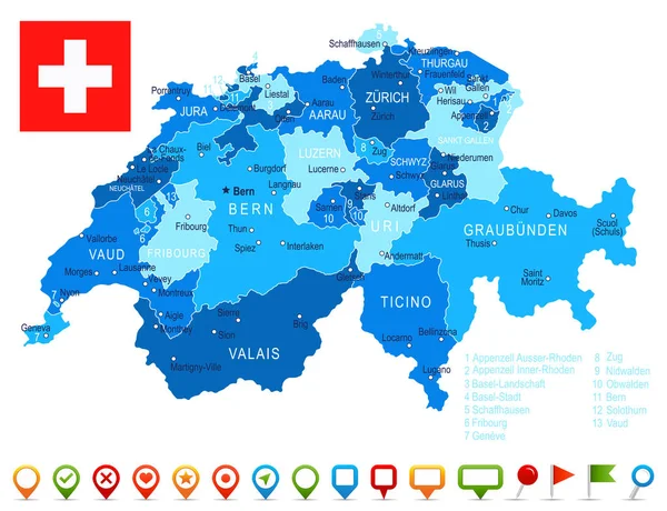
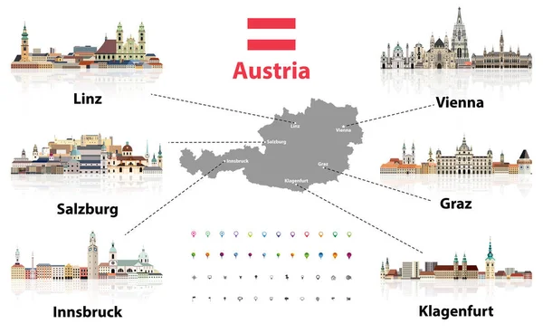
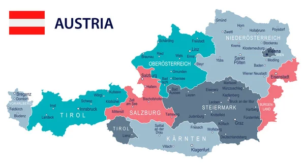
Stock vector Austria map. image of a global map in the form of regions of Austria regions. Country flag. Infographic timeline.
Published:
Feb.03, 2021 10:45:11
Author:
zajchenka240488.gmail.com
Views:
0
Downloads:
0
File type:
vector
/
eps
File size:
0.57 MB
Orginal size:
8000
x
4500
px
Available sizes:
S
(500 x 281)
M
(1000 x 563)
L
(2000 x 1125)
XL
(8000 x 4500)
VECT
(8000 x 4500)
EL0
(8000 x 4500)
Level:
beginner
Download Vector
Vector topics:
Background
Graphic
Illustration
Design
Abstract
Light
Form
Connection
Electric
Technology
Line
Border
Flag
Modern
Symbol
Creative
Concept
Futuristic
Communication
Digital
Network
Internet
Contour
Telecommunications
Grid
Geometric
Europe
Point
Journey
Country
District
Map
Cartography
Geography
National
State
Cyberspace
Computing
Statistics
Community
Republic
Region
Vote
Population
Election
Austria
Nation
Timeline
Infographics
Infographic
Similar stock vectors
Silhouettes Of The Federal States Of Austria Map, Vector Illustration. Separated Regions Of Austria. Burgenland, Carinthia, Lower Austria, Salzburg, Styria, Tyrol, Upper Austria, Vienna, Voralberg Map
5827 × 4158
Silhouettes Of The Federal States Of Austria Map, Vector Illustration. Separated Regions Of Austria. Burgenland, Carinthia, Lower Austria, Salzburg, Styria, Tyrol, Upper Austria, Vienna, Voralberg Map
5827 × 4158
Austria Vector Map Infographic Template. Slide Presentation. Vienna, Salzburg, Innsbrug, Graz. Color Europe Country. World Transportation Geography Data.
6667 × 3751
Switzerland - Map And Flag Illustration
7677 × 5900
Austria Map With Main Austrian Cities Skylines' Flat Style Colorful Icons. Navigation And Location Icons Set. Vector Illustration
8334 × 5120
Austria - Map And Flag Illustration
8700 × 4806