photo free
Home Images Vectors Videos

Stock vector Barbados - detailed blue country map with cities and regions. Vector illustration.

Stock vector Barbados - detailed blue country map with cities and regions. Vector illustration.
Published: Sep.26, 2024 04:52:26
Author: gt29
Views: 0
Downloads: 0
File type: vector / eps
File size: 0.63 MB
Orginal size: 6965 x 8248 px
Available sizes:
S
(422 x 500)
M
(844 x 1000)
L
(1689 x 2000)
XL
(6965 x 8248)
VECT
(6965 x 8248)
EL0
(6965 x 8248)
Level: bronze
Download Vector
Vector topics:

Similar stock vectors

stock vector Blue map of Barbados administrative divisions with travel infographic icons. Vector illustration

Blue Map Of Barbados Administrative Divisions With Travel Infographic Icons. Vector Illustration

5656 × 5331
stock vector Barbados - detailed country map with cities and regions. Infographic icons. Vector illustration

Barbados - Detailed Country Map With Cities And Regions. Infographic Icons. Vector Illustration

6965 × 8710
stock vector Barbados - detailed map with administrative divisions and country flag. Vector illustration

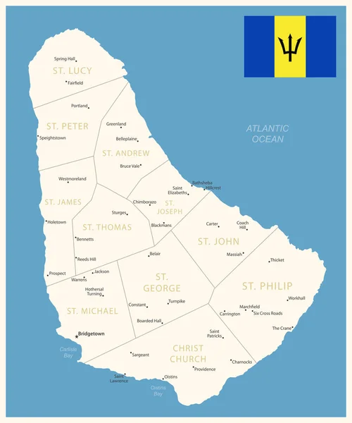
Barbados - Detailed Map With Administrative Divisions And Country Flag. Vector Illustration

6025 × 7227
stock vector Barbados administrative blue-green map with country flag and location on a globe. Vector illustration

Barbados Administrative Blue-green Map With Country Flag And Location On A Globe. Vector Illustration

5251 × 5714
stock vector Blue-green detailed map of Barbados administrative divisions with country flag and location on the globe. Vector illustration

Blue-green Detailed Map Of Barbados Administrative Divisions With Country Flag And Location On The Globe. Vector Illustration

5243 × 6326
stock vector Barbados map with regions and labels black

Barbados Map With Regions And Labels Black

5500 × 7126
stock vector White vector map of Barbados with black borders and names of it's parishes

White Vector Map Of Barbados With Black Borders And Names Of It's Parishes

4262 × 5505
stock vector White vector map of Dominica with black borders and names of it's parishes

White Vector Map Of Dominica With Black Borders And Names Of It's Parishes

3214 × 6010