Home
Images
Vectors
Videos
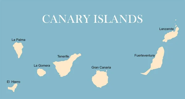
Stock vector Canary islands map hand drawing doodle outline blue isolated travelling concept
Published:
Nov.15, 2017 11:46:27
Author:
tereez
Views:
640
Downloads:
5
File type:
vector
/
eps
File size:
1.36 MB
Orginal size:
5779
x
3500
px
Available sizes:
S
(500 x 303)
M
(1000 x 606)
L
(2000 x 1211)
XL
(5779 x 3500)
VECT
(5779 x 3500)
EL0
(5779 x 3500)
Level:
bronze
Download Vector
Vector topics:
White
Blue
Vector
Background
Illustration
Design
Isolated
Art
Travel
Sun
Abstract
Texture
Travelling
Sea
Border
Symbol
Concept
Icon
Text
Drawing
World
Tourism
Europe
Vacation
Outline
Map
Cartography
Geography
Spain
Island
Stamp
Doodle
Spanish
Canary
Hand Drawn
Canary Islands Map
Similar stock vectors
World Map With Canary Islands
5577 × 3000
World Map With Canary Islands
5577 × 3000
Map Of Canary Islands, Spain, With Labels Of Each Island - El Hierro, La Palma, La Gomera, Tenerife, Gran Canaria, Fuerteventura And Lanzarote. Black Vector Silhouette On White Background
4800 × 3600
Canary Islands Drawing Doodle Colorful Summer Concept
5000 × 5000
Vector Contour Dotted Map Of El Hierro Island With Name
5517 × 3600
Map Of Canary Islands, Spain, With Labels Of Each Island - El Hierro, La Palma, La Gomera, Tenerife, Gran Canaria, Fuerteventura And Lanzarote. Black Vector Silhouette On White Background
4800 × 3600
Canary Islands Political Map With Lanzarote, Fuerteventura, Gran Canaria, Tenerife, La Gomera, La Palma And El Hierro. English Labeling And Scaling. Illustration.
7176 × 3096
Pixelated Pattern Map Of El Hierro Island
7046 × 3538