Home
Images
Vectors
Videos
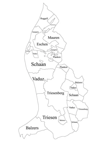
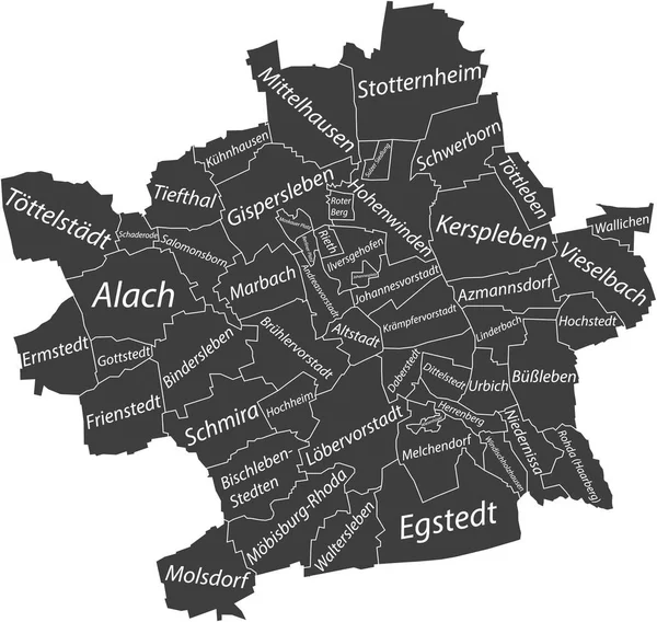
Stock vector Dark gray flat vector administrative map of ERFURT, GERMANY with name tags and white border lines of its districts
Published:
Jun.07, 2022 07:45:06
Author:
momcilo.jovanov
Views:
1
Downloads:
0
File type:
vector
/
eps
File size:
1.03 MB
Orginal size:
5108
x
4839
px
Available sizes:
S
(500 x 474)
M
(1000 x 947)
L
(2000 x 1895)
XL
(5108 x 4839)
VECT
(5108 x 4839)
EL0
(5108 x 4839)
Level:
bronze
Download Vector
Vector topics:
Vector
Curve
Illustration
Design
Sign
Travel
Transportation
Mountain
Car
Road
Traffic
Symbol
Icon
City
House
Data
Planning
Highway
Town
Journey
Outline
Direction
Map
Cartography
Germany
Land
Patriotism
Asphalt
Government
Community
Berlin
Erfurt
Infographic
Coat Of Arms
Cut Out
European Union
Travel Destinations
Residential District
No People
German Culture
Global Positioning System
Physical Geography
Construction Industry
Road Map
Navigational Equipment
Transparent Background
German Language
Plan Document
Landscape Scenery
Borough District Type
Similar stock vectors
White Flat Vector Administrative Map Of ERFURT, GERMANY With Name Tags And Black Border Lines Of Its Districts
5108 × 4839
Pastel Flat Vector Administrative Map Of ERFURT, GERMANY With Name Tags And Black Border Lines Of Its Districts
5108 × 4839
Dark Gray Flat Vector Administrative Map Of RECKLINGHAUSEN, GERMANY With Name Tags And White Border Lines Of Its Districts
4919 × 4858
Dark Gray Flat Vector Administrative Map Of KASSEL, GERMANY With Name Tags And White Border Lines Of Its Districts
5506 × 4400
White Flat Vector Administrative Map Of ERLANGEN, GERMANY With Name Tags And Black Border Lines Of Its Districts
4398 × 5511
White Flat Vector Administrative Map Of RECKLINGHAUSEN, GERMANY With Name Tags And Black Border Lines Of Its Districts
4919 × 4858
White Labeled Municipalities Map Of European Country Of Liechtenstein
3600 × 4800
Dark Gray Flat Vector Administrative Map Of SALZGITTER, GERMANY With Name Tags And White Border Lines Of Its Districts
4469 × 5508