Home
Images
Vectors
Videos
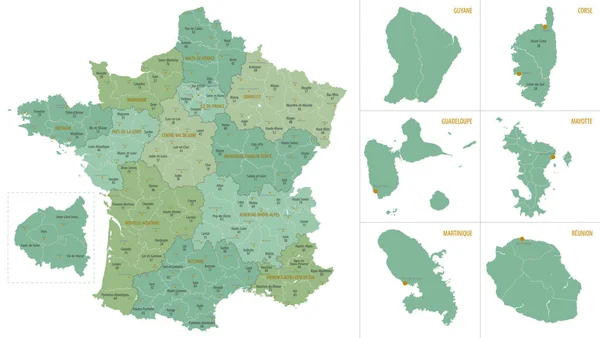
Stock vector Detailed map of metropolis and overseas territories of France with administrative divisions into regions and departments, large cities of the country, vector illustration on a white background
Published:
Jan.19, 2021 15:23:01
Author:
martinova4
Views:
56
Downloads:
7
File type:
vector
/
eps
File size:
4.5 MB
Orginal size:
7677
x
4326
px
Available sizes:
S
(500 x 282)
M
(1000 x 564)
L
(2000 x 1127)
XL
(7677 x 4326)
VECT
(7677 x 4326)
EL0
(7677 x 4326)
Level:
beginner
Download Vector
Vector topics:
Vector
Background
Isolated
Travel
Border
Flag
Icon
City
Contour
World
France
Capital
Globe
Country
Map
Cartography
Geography
Area
Mediterranean
Centre
Island
Political
Administrative
Europa
Paris
Region
Atlas
Bretagne
Metropolitan
2016
Marseille
Cannes
Martinique
Guadeloupe
Lyon
Normandie
Corse
Departments
Mayotte
Guyane
North Sea
Pays De La Loire
Ile De France
Centre Val De Loire
Grand Est
Occitanie
Nouvelle Aquitaine
Oversea Territorie
Nauts De France
Similar stock vectors
Vector Color Detailed Map Of Metropolis And Overseas Territories Of France With Administrative Divisions Of The Country, Each Region Is Presented Separately In-highly Detailed And Divided Into Departments
7677 × 4274
Angola - Highly Detailed Black And White Map.
7373 × 5001
Vector Population Map Of The Turkish Provinces
6466 × 3100
Uganda - Highly Detailed Black And White Map. Vector Illustration
5251 × 7111
Detailed Map Of Bulgaria With Administrative Divisions Of The Country, Color Vector Illustration
7677 × 2958
Highly Detailed Editable Political Map With Separated Layers. Estonia.
3000 × 2012
Shape Of Jeollabuk-do, Province Of South Korea, With Its Capital Isolated On White Background. Satellite Imagery. 3D Rendering
3836 × 2390
Vector Color Detailed Map Of Lithuania With Administrative Divisions Of The Country, Each Counties Is Presented Separately In-highly Detailed And Divided Into Municipalities
7677 × 3587