Home
Images
Vectors
Videos
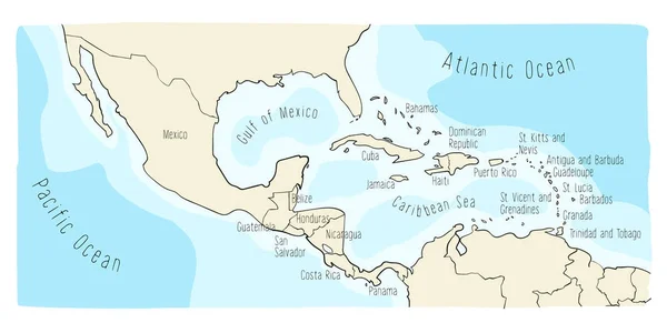
Stock vector Doodle Map of Central America and Mexico
Published:
Jan.03, 2018 12:10:42
Author:
LaraFields
Views:
343
Downloads:
2
File type:
vector
/
eps
File size:
4.15 MB
Orginal size:
6000
x
3002
px
Available sizes:
S
(500 x 250)
M
(1000 x 500)
L
(2000 x 1001)
XL
(6000 x 3002)
VECT
(6000 x 3002)
EL0
(6000 x 3002)
Level:
beginner
Download Vector
Vector topics:
Vector
Colorful
Graphic
Element
Illustration
Travel
Abstract
Line
Silhouette
Cartoon
Hand
Comic
Concept
Digital
Global
Pen
Drawing
Education
Earth
World
American
Ocean
North
South
Sketch
Outline
Country
Map
Cartography
Geography
Continent
Land
Worldwide
Drawn
America
Political
States
Doodle
Central
Panama
Mexico
Atlas
Cuba
Sketchy
Belize
Haiti
Nicaragua
Infographic
Hand Drawn
Dominican Republic
Similar stock vectors
Doodle Map Of Central America And Mexico
6000 × 3002
Doodle Map Of Central America And Mexico
6000 × 3002
Doodle Map Of Central America And Mexico
6000 × 3002
Panama Highly Detailed Vector Map With Administrative Regions, Main Cities And Roads.
5500 × 2522
Zoomed-in View Of Mexico Outline With Perspective Lines Against A Global Map In The Mollweide Projection. Shape On The Left Side. Satellite Imagery
2880 × 1620
Panama In Red On Earth
5000 × 3750
Panama From Space On Model Of Planet Earth With Country Borders And Very Detailed Planet Surface. 3D Illustration. Elements Of This Image Furnished By NASA.
5000 × 3750
Ciego De Avila, Province Of Cuba. High Resolution Satellite Map. Corner Auxiliary Location Maps
4930 × 3770