Home
Images
Vectors
Videos
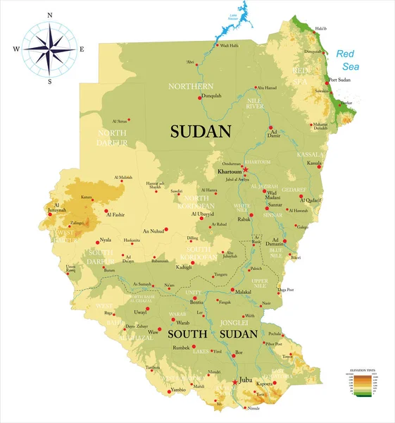
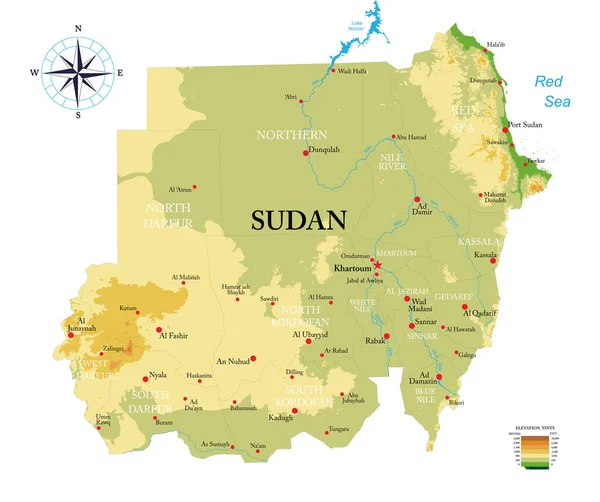
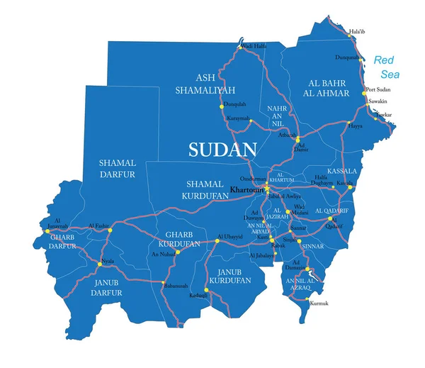
Stock vector Highly detailed vector map of Sudan,with administrative regions,main cities and roads.
Published:
Dec.01, 2020 12:55:51
Author:
BogdanSerban
Views:
0
Downloads:
0
File type:
vector
/
eps
File size:
1.75 MB
Orginal size:
7500
x
6489
px
Available sizes:
S
(500 x 433)
M
(1000 x 865)
L
(2000 x 1730)
XL
(7500 x 6489)
VECT
(7500 x 6489)
EL0
(7500 x 6489)
Level:
beginner
Download Vector
Vector topics:
Vector
Background
Illustration
Isolated
Travel
Silhouette
Border
Road
City
Outline
Country
Map
Cartography
Geography
Africa
Destination
Eps
Sudan
Khartoum
Nyala
Omdurman
Kusti
Kassala
Wad Madani
Al Ubayyid
Al Qadarif
Kaduqli
Ad Damir
Al Fashir
Sinjah
Similar stock vectors
Sudan Poster In Retro Style. Map Of The Country With Regions In Autumn Color Palette. Shape Of Sudan With Country Name. Appealing Vector Illustration.
5470 × 5500
Vector People Map Of Sudan. The Concept Of Population. Can Be Used For Presentations, Advertising, Infographics And The Visualization Of The Statistics.
5000 × 5000
Sudan And South Sudan Highly Detailed Physical Map
7021 × 7500
Sudan Poster Map Of The Country With Colorful Regions Shape Of Sudan With Country Name Classy
5496 × 5469
Sudan Higt Detailed Map With Subdivisions. Administrative Map Of Sudan With Districts And Cities Name, Colored By States And Administrative Districts. Vector Illustration With Editable And Labelled Layers.
4000 × 4000
Vector Map Of Sudan Isolated On White Background.
5000 × 5000
Chad Highly Detailed Vector Map With Administrative Regions, Main Cities And Roads.
3764 × 5000
Sudan Highly Detailed Physical Map
7500 × 6280