Home
Images
Vectors
Videos
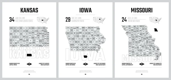
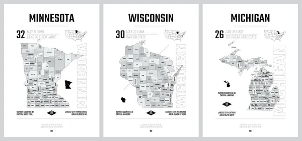
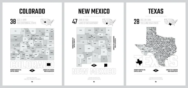
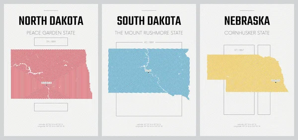
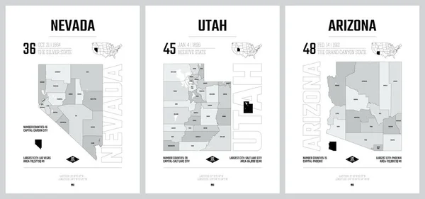
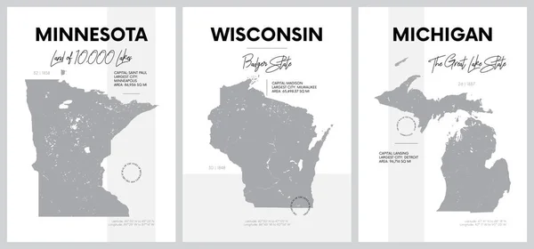
Stock vector Highly detailed vector silhouettes of US state maps, Division United States into counties, political and geographic subdivisions of a states, West North Central - North Dakota, South Dakota, Nebraska - set 7 of 17
Published:
Nov.22, 2021 13:55:55
Author:
Max_776
Views:
3
Downloads:
1
File type:
vector
/
eps
File size:
6.36 MB
Orginal size:
9608
x
4501
px
Available sizes:
S
(500 x 234)
M
(1000 x 468)
L
(2000 x 937)
XL
(9608 x 4501)
VECT
(9608 x 4501)
EL0
(9608 x 4501)
Level:
bronze
Download Vector
Vector topics:
Vector
Design
High
Art
Travel
Line
Silhouette
Border
Gray
City
Contour
World
Us
Usa
Detailed
North
Print
South
Outline
District
Map
Cartography
Geography
Plan
Land
State
Poster
America
Administrative
Politics
Stamp
Aerial
United
Region
Division
Separated
Federal
Postage
Lincoln
County
Borough
Dakota
Nebraska
Counties
Bismarck
Omaha
Fargo
United States
Sioux Falls
West North Central
Similar stock vectors
Highly Detailed Vector Silhouettes Of US State Maps, Division United States Into Counties, Political And Geographic Subdivisions Of A States, West North Central - Kansas, Iowa, Missouri - Set 6 Of 17
9608 × 4501
Highly Detailed Vector Silhouettes Of US State Maps, Division United States Into Counties, Political And Geographic Subdivisions Of A States, The Great Lakes Region - Minnesota, Wisconsin, Michigan - Set 5 Of 17
9608 × 4501
Highly Detailed Vector Silhouettes Of US State Maps, Division United States Into Counties, Political And Geographic Subdivisions Of A States, Mountain And West South Central - Colorado, New Mexico, Texas - Set 13 Of 17
9608 × 4501
Highly Detailed Vector Silhouettes Of US State Maps, Division United States Into Counties, Political And Geographic Subdivisions Of A States, Mountain - Nevada, Utah, Arizona - Set 15 Of 17
9608 × 4501
Vector Posters Detailed Silhouettes Maps Of The States Of America With Abstract Linear Pattern, Division West North Central - North Dakota, South Dakota, Nebraska - Set 7 Of 17
8896 × 4168
Highly Detailed Vector Silhouettes Of US State Maps, Division United States Into Counties, Political And Geographic Subdivisions Of A States, Mountain - Nevada, Utah, Arizona - Set 14 Of 17
9608 × 4501
Highly Detailed Vector Silhouettes Of US State Maps, Division United States Into Counties, Political And Geographic Subdivisions Of A States, East North Central - Illinois, Indiana, Ohio - Set 4 Of 17
9608 × 4501
Vector Posters With Highly Detailed Silhouettes Of Maps Of The S
7292 × 3416