Home
Images
Vectors
Videos
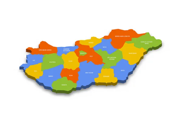
Stock vector Hungary political map of administrative divisions - counties and autonomous city of Budapest. Colorful 3D vector map with country province names and dropped shadow.
Published:
Jun.23, 2023 12:30:04
Author:
pyty
Views:
2
Downloads:
0
File type:
vector
/
eps
File size:
20.72 MB
Orginal size:
8000
x
5333
px
Available sizes:
S
(500 x 333)
M
(1000 x 667)
L
(2000 x 1333)
XL
(8000 x 5333)
VECT
(8000 x 5333)
EL0
(8000 x 5333)
Level:
silver
Download Vector
Vector topics:
Color
Vector
Colorful
Illustration
Design
Label
Border
3d
City
Shadow
Detailed
Europe
Country
District
Map
Cartography
Geography
Area
National
Land
Four
Unit
State
Sovereign
Boundary
Government
Political
Administrative
Department
Region
Division
Federal
Atlas
Local
Budapest
Hungary
Hungarian
Magyar
Province
Nation
Subdivision
County
Geographical
Regional
Divided
Autonomy
Entity
Autonomous
Unitary
Infographic
Similar stock vectors
Slovenia Political Map Of Administrative Divisions - Statistical Regions. Colorful 3D Vector Map With Country Province Names And Dropped Shadow.
8000 × 5333
Burkina Faso Political Map Of Administrative Divisions - Regions. Colorful 3D Vector Map With Country Province Names And Dropped Shadow.
8000 × 8000
Bulgaria Map
6002 × 3929
Afghanistan - Regional Map Of Provinces
8000 × 6000
Map Of Bacs-Kiskun. Hungary.
5600 × 4200
Ivory Coast Political Map Of Administrative Divisions - Regions And Autonomous Districts. Colorful 3D Vector Map With Country Province Names And Dropped Shadow.
8000 × 8000
Bulgaria Political Map Of Administrative Divisions - Provinces And Regions. Colorful 3D Vector Map With Country Province Names And Dropped Shadow.
8000 × 5333
Map Of Fejer. Hungary.
5600 × 4200