Home
Images
Vectors
Videos
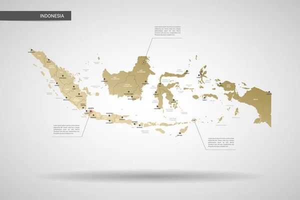
Stock vector Indonesia map with borders, cities, capital and administrative divisions. Infographic vector map. Editable layers clearly labeled.
Published:
Sep.18, 2018 08:26:43
Author:
molokowall
Views:
84
Downloads:
1
File type:
vector
/
eps
File size:
2.7 MB
Orginal size:
4000
x
2571
px
Available sizes:
S
(500 x 321)
M
(1000 x 643)
L
(2000 x 1286)
XL
(4000 x 2571)
VECT
(4000 x 2571)
EL0
(4000 x 2571)
Level:
bronze
Download Vector
Vector topics:
White
Vector
Background
Circle
Isolated
Travel
Orange
Border
Symbol
City
Button
Contour
Grey
Information
Education
World
Town
Identity
Outline
Country
District
Map
Cartography
Geography
National
Continent
Land
Ground
State
Topography
Location
Political
Politics
Geographic
Region
Territory
Atlas
Nation
Subdivision
Indonesia
Mapping
Infographic
Travel Map
Vector Map
Indonesia Map
Similar stock vectors
Stylized Vector Indonesia Map. Infographic 3d Gold Map Illustration With Cities, Borders, Capital, Administrative Divisions And Pointer Marks, Shadow; Gradient Background.
4500 × 3000
Indonesia Country Map
5000 × 4286
Indonesia - Map And Flag Illustration
8700 × 4602
Indonesia Vector Map Infographic Template. Slide Presentation. Global Business Marketing Concept. Asia Country. World Transportation Geography Data.
6667 × 3751
Infographic Of Indonesia Map There Is Flag And Population,religion Chart And Capital Government Currency And Language, Vector Illustration
5000 × 3000
Modern Of Indonesia Map Connections Network Design, Best Internet Concept Of Indonesia Map Business From Concepts Series, Map Point And Line Composition. Infographic Map. Vector Illustration.
5000 × 3500
Indonesia Communication Network Map. Vector Image Of A Low Poly Global Map With City Lights.
8192 × 5595