Home
Images
Vectors
Videos
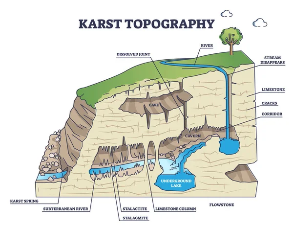
Stock vector Karst topography and geological underground cave formation outline diagram
Published:
Oct.12, 2021 12:18:17
Author:
VectorMine
Views:
161
Downloads:
2
File type:
vector
/
eps
File size:
6.03 MB
Orginal size:
5000
x
3889
px
Available sizes:
S
(500 x 389)
M
(1000 x 778)
L
(2000 x 1556)
XL
(5000 x 3889)
VECT
(5000 x 3889)
EL0
(5000 x 3889)
Level:
silver
Download Vector
Vector topics:
Vector
View
Illustration
Side
Nature
Spring
River
Concept
Stream
Structure
Earth
Rock
Science
Detailed
Section
Outline
Geography
Land
Ground
Graph
Joint
Topography
Underground
Corridor
Geological
Scheme
Illustrations
Layers
Limestone
Formation
Educational
Diagram
Cave
Description
Example
Tunnel
Forms
Explanation
Cracks
Erosion
Stalactite
Karst
Stalagmite
Cavern
Subterranean
Landforms
Labeled
Flowstone
Infographics
Similar stock vectors
Watershed As Water Basin System With Mountain River Streams Outline Diagram
4400 × 3800
The Karst Landforms And Cycle Of Erosion
4241 × 3817
Vector Cartoon Illustration Of 3D Land With Types Of Estuaries. Infographic Design. Coastal Plain, Bar Built Estuary, Tectonic Estuary, Fjord.
3000 × 2842
Sapropel And Peat In Nature. Structure Of Pond And Marsh With Bottom Sediments
8217 × 3551
Vector Illustration Of Hydrogeology In Karst Relief - Section.
3500 × 6194
Types Of Seismic Waves As Earth Movement In Earthquake Outline Collection Set. Educational Labeled Rayleigh, Love And Body, Surface Wave Comparison With Direction Explanation Vector Illustration.
4500 × 3600
Metamorphism Vector Illustration. Labeled Mineral Geologic Structure Change
4000 × 4000
Illustration Of Physics And Geography, Plates Tectonic, Two Continental Plates Converge, Understanding Plates Motion, Plate Tectonics Theory
4155 × 2709