Home
Images
Vectors
Videos
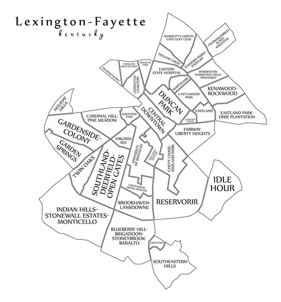
Stock vector Lexington-Fayette Kentucky city map with neighborhoods grey illustration silhouette shape
Published:
Jul.20, 2018 07:32:21
Author:
ingomenhard
Views:
1
Downloads:
0
File type:
vector
/
eps
File size:
4.35 MB
Orginal size:
5000
x
5982
px
Available sizes:
S
(418 x 500)
M
(836 x 1000)
L
(1672 x 2000)
XL
(5000 x 5982)
VECT
(5000 x 5982)
EL0
(5000 x 5982)
Level:
bronze
Download Vector
Vector topics:
Vector
Graphic
Illustration
Design
Isolated
Shape
New
Silhouette
Border
Modern
City
Flat
Grey
Simple
Usa
Country
Map
Area
Trip
State
Administrative
Department
Region
Division
Territory
Province
Neighborhood
County
Divisions
Regional
Districts
Kentucky
Regions
Fayette
Lexington
United States
United States Of America
Similar stock vectors
Lexington-Fayette Kentucky City Map Grey Illustration Silhouette Shape
5000 × 5982
Lexington Vector Map. Detailed Vector Map Of Lexington City Administrative Area. Cityscape Poster Metropolitan Aria View. Black Land With White Roads And Avenues. White Background.
4534 × 5268
Lexington Vector Map. Detailed Map Of Lexington City Administrative Area. Cityscape Panorama. Royalty Free Vector Illustration. Road Map With Highways, Rivers.
4534 × 5268
Greensboro North Carolina City Map Grey Illustration Silhouette Shape
5930 × 5000
Modern City Map - Louisville Kentucky City Of The USA With Neighborhoods
6216 × 5000
Raleigh Map. Detailed Map Of Raleigh City Administrative Area. Cityscape Panorama. Royalty Free Vector Illustration. Outline Map With Highways, Streets, Rivers. Tourist Decorative Street Map.
8651 × 8335
Large And Detailed Map Of Lafayette County In Arkansas, USA.
5000 × 3200
Modern City Map - Lexington-Fayette Kentucky City Of The USA With Neighborhoods And Titles Outline
5000 × 5372