Home
Images
Vectors
Videos
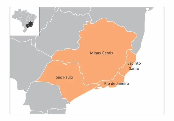
Stock vector Map of the Brazil southeast region with the main cities isolated on white background
Published:
Apr.21, 2020 07:18:11
Author:
luisrftc
Views:
46
Downloads:
2
File type:
vector
/
eps
File size:
8.32 MB
Orginal size:
5000
x
3500
px
Available sizes:
S
(500 x 350)
M
(1000 x 700)
L
(2000 x 1400)
XL
(5000 x 3500)
VECT
(5000 x 3500)
EL0
(5000 x 3500)
Level:
bronze
Download Vector
Vector topics:
White
Vector
Graphic
Isolated
Border
Flag
Gray
Icon
American
Capital
South
Outline
Country
Map
Cartography
Geography
Area
State
America
Political
Administrative
States
Region
Cities
Brazil
Main
Borderline
De
Southeast
Province
Divisions
Mapping
Brazilian
Rio
Janeiro
Santo
Sao
Regions
Paulo
Espirito
Minas
Vitoria
Gerais
Sao Paulo
Rio De Janeiro
Belo Horizonte
Minas Gerais
Espírito Santo
Southeast Region
Similar stock vectors
Brazil Northeast Region Map
5000 × 5000
Brazil Northeast Region
5000 × 5000
Brazil North Region
5000 × 3500
Map Of The Brazil Center-west Region With The Main Cities Isolated On White Background
5000 × 5000
Rio Grande Do Norte State Brazil
3504 × 5504
Map Of The Southeast Region Of Brazil With The Identified States
5000 × 3500
Brazil Center-west Region
5000 × 5000
Map Of Piaui. Brazil.
5600 × 4200