Home
Images
Vectors
Videos
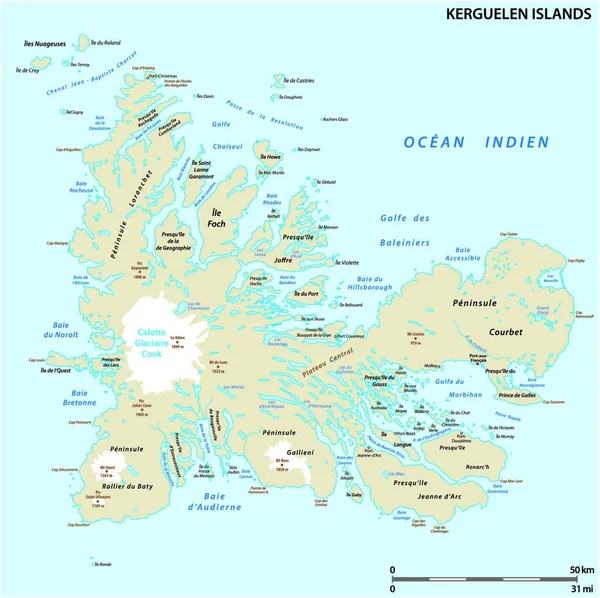
Stock vector Map of the French archipelago of the Kerguelen
Published:
Sep.10, 2019 10:25:34
Author:
Lesniewski
Views:
16
Downloads:
0
File type:
vector
/
eps
File size:
2.9 MB
Orginal size:
3105
x
3100
px
Available sizes:
S
(500 x 499)
M
(1000 x 998)
L
(2000 x 1997)
XL
(3105 x 3100)
VECT
(3105 x 3100)
EL0
(3105 x 3100)
Level:
bronze
Download Vector
Vector topics:
Group
White
Vector
Illustration
Art
Travel
Mountain
Black
French
Picture
Drawing
France
Bay
Artwork
Country
Map
Cartography
Geography
Historic
Topography
Island
Gulf
Antarctic
Destination
Overseas
Islands
Region
Engraved
Southern
Desolation
Engraving
Peninsula
Fjords
Glaciers
Etching
Geographical
Lands
Indian Ocean
Archipel
Kerguelen
Antarctic Lands
Main Island
Grande Terre
Kerguelen Islands
Desolation Islands
Similar stock vectors
Map Of The French Archipelago Of The Kerguelen
4000 × 3999
Highly Detailed Editable Political Map With Separated Layers. Iceland.
4400 × 3110
High Detailed Iceland Road Map With Labeling.
4400 × 3110
Map Of The Archipelago Nova Zemlya In The Arctic Ocean In Northe
3104 × 3100
Falkland Islands, Also Malvinas, Political Vector Road Map.
4791 × 3100
Roads And National Parks Map Of The European Island Nation Of Iceland
4246 × 3100
Map Of Iceland
7021 × 5321