Home
Images
Vectors
Videos
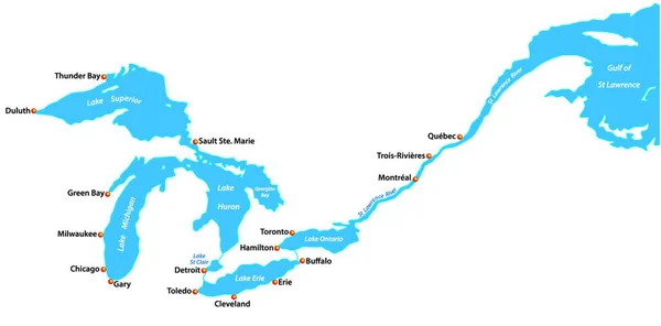
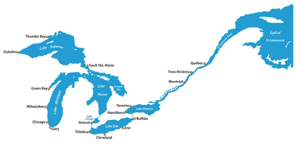
Stock vector Map of the great lakes and st lawrence river with major cities
Published:
Jan.20, 2020 08:59:29
Author:
Lesniewski
Views:
34
Downloads:
1
File type:
vector
/
eps
File size:
0.69 MB
Orginal size:
6119
x
3100
px
Available sizes:
S
(500 x 253)
M
(1000 x 507)
L
(2000 x 1013)
XL
(6119 x 3100)
VECT
(6119 x 3100)
EL0
(6119 x 3100)
Level:
bronze
Download Vector
Vector topics:
Blue
Vector
Background
Illustration
Isolated
Travel
Abstract
Line
Silhouette
Border
River
Symbol
City
Contour
Usa
Outline
Map
Cartography
Geography
Lake
Superior
Buffalo
Topography
Great
Canada
Toronto
Lakes
Mapping
Montreal
Quebec
Chicago
Erie
Michigan
Detroit
Huron
Cleveland
Milwaukee
North America
United States
Atlantic Ocean
Great Lakes
Great Lakes Region
Saint Lawrence River
Saint Clair
James Bay
Similar stock vectors
Map Of The Great Lakes And St Lawrence River With Major Cities
4000 × 3620
Lake Pend Oreille (United States, North America, Us) Map Vector Illustration, Scribble Sketch Map
7087 × 4726
Silhouette Map Of The Baltic Sea In Northern Europe
3463 × 3866
Cartoon Icon Lake. Vector Illustration Water Concept In Flat Style.
5001 × 4167
Map Of Panama. High Detailed Vector Map - Panama.
5000 × 3500
Cuba Map Country Icon In Solid Style
5001 × 1887
Vector Map Of The Ten Largest Lake In Germany In German
3984 × 5057
Lake Athabasca (Canada, North America) Map Vector Illustration, Scribble Sketch Map
7087 × 4726