Home
Images
Vectors
Videos
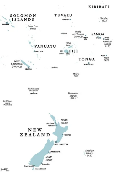
Stock vector New Zealand and southern Polynesia, gray political map with capitals. Solomon Islands, Vanuatu, Fiji, Tonga, Samoa and New Caledonia. Islands in the South Pacific Ocean. English. Illustration. Vector.
Published:
Dec.14, 2021 07:08:30
Author:
PantherMediaSeller
Views:
6
Downloads:
0
File type:
vector
/
zip
File size:
0 MB
Orginal size:
3622
x
4000
px
Available sizes:
S
(453 x 500)
M
(906 x 1000)
L
(1811 x 2000)
XL
(3622 x 4000)
VECT
(3622 x 4000)
EL0
(3622 x 4000)
Level:
platinum
Download Vector
Vector topics:
New
Gray
Ocean
South
Map
Pacific
Political
Islands
Southern
ZEALAND
And
Polynesia
New Zealand
NEW CALEDONIA
Similar stock vectors
New Zealand Map - Vintage Vector Illustration
5500 × 7194
New Zealand And Southern Polynesia, Political Map With Capitals. Solomon Islands, Vanuatu, Fiji, Tonga, Samoa And New Caledonia. South Pacific Ocean Islands. English Labeling. Illustration. Vector.
3622 × 4000
Physical Vector Map Of The Island Nation Of New Zealand
3100 × 3890
New Zealand Physiography Map
4331 × 5661
Green Map Of New Zealand With Outline Vector Design Template. Editable Stroke
5000 × 5000
Map Of New Zealand
3348 × 4779
Blue-gray Detailed Map Of New Zealand And Administrative Divisions And Location On The Globe. Vector Illustration
5251 × 6264
New Zealand Political Map Isolated On White
5876 × 5224