Home
Images
Vectors
Videos
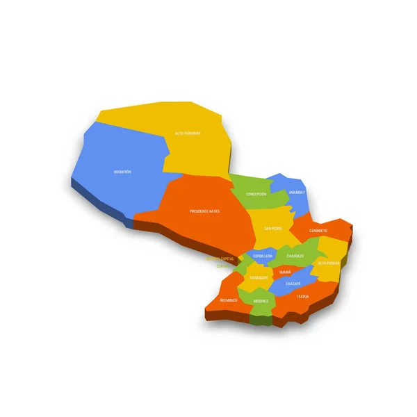
Stock vector Paraguay political map of administrative divisions - departments and capital district. Shaded vector map with 3D-like blue gradient and name labels
Published:
Aug.06, 2024 12:59:53
Author:
pyty
Views:
0
Downloads:
0
File type:
vector
/
eps
File size:
0.34 MB
Orginal size:
10000
x
10000
px
Available sizes:
S
(500 x 500)
M
(1000 x 1000)
L
(2000 x 2000)
XL
(10000 x 10000)
VECT
(10000 x 10000)
EL0
(10000 x 10000)
Level:
silver
Download Vector
Vector topics:
Blue
Vector
Illustration
Design
Label
Border
3d
Flat
Shadow
Gradient
Detailed
Capital
Shade
Name
Country
District
Map
Cartography
Geography
Area
National
Land
Unit
State
Sovereign
Boundary
Government
Political
Administrative
Department
Region
Division
Federal
Atlas
Local
Province
Subdivision
Paraguay
Geographical
Regional
Divided
Autonomy
Entity
Autonomous
Paraguayan
Asuncion
Unitary
Infographic
South America
Similar stock vectors
Paraguay Political Map Of Administrative Divisions - Departments And Capital District. Colorful 3D Vector Map With Country Province Names And Dropped Shadow.
8000 × 8000
El Salvador Political Map Of Administrative Divisions - Departments. Colorful 3D Vector Map With Country Province Names And Dropped Shadow.
8000 × 5333
Map Of Paraguay. High Detailed Vector Map - Paraguay.
5000 × 3500
Tanzania Political Map Of Administrative Divisions - Regions. Colorful 3D Vector Map With Country Province Names And Dropped Shadow.
8000 × 8000
Flat Design Map Of Dominica With Details
2401 × 2401
Blue Map Of Senegal On White Background.
10417 × 7292
Flat Design Map Of Samoa With Details
3001 × 2001
Armenia Political Map Of Administrative Divisions - Provinces And Autonomous City Of Yerevan. Colorful 3D Vector Map With Country Province Names And Dropped Shadow.
8000 × 8000