Home
Images
Vectors
Videos
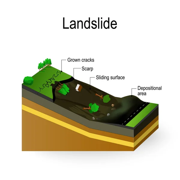
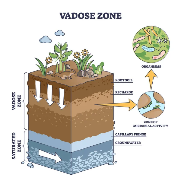
Stock vector Vadose or unsaturated zone as geological earth layer division outline diagram
Published:
Nov.08, 2021 07:16:01
Author:
VectorMine
Views:
80
Downloads:
0
File type:
vector
/
eps
File size:
6.16 MB
Orginal size:
4000
x
4000
px
Available sizes:
S
(500 x 500)
M
(1000 x 1000)
L
(2000 x 2000)
XL
(4000 x 4000)
VECT
(4000 x 4000)
EL0
(4000 x 4000)
Level:
silver
Download Vector
Vector topics:
Table
Activity
Vector
Illustration
Field
Nature
Environment
Water
Botany
Saturated
Concept
Structure
Ecology
Earth
Environmental
Rock
Biology
Soil
System
Underwater
Outline
Fringe
Land
Ground
Geology
Climate
Layer
Scheme
Educational
Division
Diagram
Root
Description
Recharge
Explanation
Terrestrial
Zone
Groundwater
Capillary
Areas
Labeled
Hydrology
Subsurface
Unsaturated
Microorganisms
Hydrogeology
Microbial
Zonation
Vadose
Similar stock vectors
Landslide. Vector Diagram
4202 × 4202
Artesian Water Well Construction In Cross Section, Schematic Education Poster. Groundwater, Sand, Gravel, Loam, Clay, Extraction Of Moisture From The Soil, Vector Illustration.
4000 × 5000
Lake Ecosystem. Zonation In Lake Water Infographic. Pond Or River Freshwater Zones Diagram With Text For Education. Lake Ecosystems Division Into Littoral, Open Water And Deep Water Zones. Stock Vector Illustration
5000 × 3333
Septic Tank Diagram. Septic System And Drain Field Scheme . An Underground Septic Tank Illustration.
5000 × 3333
Lake Ecosystem. Zonation In Lake Water Infographic. Pond Or River Freshwater Zones Diagram With Text For Education. Lake Ecosystems Division Into Littoral, Open Water And Deep Water Zones. Stock Vector Illustration
5000 × 3333
Structure Of Mangrove Forest With Three Zones Diagram Illustration
5650 × 3934
Diagram Showing Transpiration In Plant
4524 × 4912
Aeration Of The Lawn. Enrichment With Oxygen Water And Nutrients To Improve Lawn Growth. Before And After Aeration: Gardening, Lawn Care Services. Advantages, Aeration. Vector
5653 × 2708