Home
Images
Vectors
Videos
Stock vector vector map of cornwall and isles of scilly united kingdom
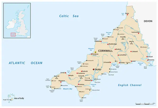
Published:
Apr.11, 2024 09:35:26
Author:
Lesniewski
Views:
2
Downloads:
1
File type:
vector
/
eps
File size:
2.75 MB
Orginal size:
4516
x
3100
px
Available sizes:
S
(500 x 343)
M
(1000 x 686)
L
(2000 x 1373)
XL
(4516 x 3100)
VECT
(4516 x 3100)
EL0
(4516 x 3100)
Level:
bronze
Download Vector
Vector topics:
Vector
Graphic
Illustration
Shape
Travel
Abstract
Colour
Border
River
Symbol
City
Sound
Scale
Bay
Coastline
Tourism
Europe
Peak
Outline
Hill
Country
West
Map
Cartography
Geography
Area
Uk
Lake
Topography
Island
Airport
Cape
Department
Britain
Region
British
England
Peninsula
County
Cornwall
Archipelago
Devon
Truro
Infographic
United Kingdom
Atlantic Ocean
English Channel
Celtic Sea
Isles Of Scilly
Similar stock vectors
Road Map Of The African Island Nation Of Madagascar
3100 × 3745
National Park Map Of The African Island Nation Of Madagascar
3100 × 3745
Madagasca Physiography Map
5161 × 6191
New Zealand South Island Administrative And Political Map
3176 × 3100
Vector Road Map Of Canary Island Fuerteventura
3100 × 3155
Madagascar - Detailed Map With Administrative Divisions And Country Flag. Vector Illustration
6043 × 7213
Newfoundland Road Map
3118 × 3101
Cuba Map - Detailed Vector Illustration
8002 × 5500