
Stock image Fayette County Map

Fayette County, Commonwealth Of Pennsylvania (U.S. County, United States Of America, USA, U.S., US) Map Vector Illustration, Scribble Sketch Fayette Map
Vector, 0.65MB, 7087 × 4726 eps

Milwaukee And Lafayette (La Fayette) County, State Of Wisconsin (U.S. County, United States Of America, US) Map Vector Illustration, Scribble Sketch Map
Vector, 0.62MB, 7087 × 4726 eps
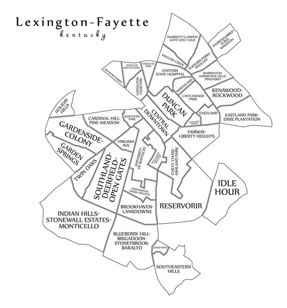
Modern City Map - Lexington-Fayette Kentucky City Of The USA With Neighborhoods And Titles Outline
Vector, 9.59MB, 5000 × 5372 eps

List Of Cities In Kentucky USA State, Map Silhouette Word Cloud Map Concept Background
Image, 9.56MB, 12500 × 8333 jpg

Kentucky, U.S. State Subdivided Into 120 Counties, Gray Political Map With Borders And County Names. Commonwealth Of Kentucky, A State In The Southeastern Region Of USA, Nicknamed The Bluegrass State.
Vector, 2.14MB, 9000 × 4352 eps

Map Of Fayette County In Georgia State On White Background. Single County Map Highlighted By Black Colour On Georgia Map. UNITED STATES, US
Image, 6.6MB, 8000 × 8000 jpg

Map Of Fayette County In Pennsylvania State On White Background. Single County Map Highlighted By Black Colour On Pennsylvania Map. UNITED STATES, US
Image, 4.22MB, 8000 × 5334 jpg

Map Of Fayette County In Ohio State On White Background. Single County Map Highlighted By Black Colour On Ohio Map. UNITED STATES, US
Image, 5.59MB, 8000 × 8000 jpg

Map Of Fayette County In Illinois State On White Background. Single County Map Highlighted By Black Colour On Illinois Map. UNITED STATES, US
Image, 5.19MB, 8000 × 8000 jpg

Kentucky, U.S. State Subdivided Into 120 Counties, Political Map With Borders And County Names. Commonwealth Of Kentucky, A State In The Southeastern Region Of The USA, Nicknamed The Bluegrass State.
Vector, 2.56MB, 9000 × 4635 eps

Kentucky, U.S. State, Multi Colored Political Map With Borders, County Names And Capital Frankfort. State In The Southeastern Region Of The United States, Subdivided Into 120 Counties. Bluegrass State
Vector, 2.16MB, 9000 × 4352 eps
Page 1 >> Next