photo free
Home Images Vectors Videos

Stock image Mitchell Map

stock vector Mitchell County (Kansas) outline map set

Mitchell County (Kansas) Outline Map Set

Vector, 0.24MB, 6000 × 3000 eps
stock vector map of the city of San Antonio, Texas, USA

Map Of The City Of San Antonio, Texas, USA

Vector, 18.3MB, 4884 × 6839 eps
stock vector Map of South Dakota

Map Of South Dakota

Vector, 0.71MB, 5000 × 4167 ai
stock vector South Dakota, SD, political map, with capital Pierre, and largest city Sioux Falls. State in the upper Midwestern subregion of the United States of America, nicknamed The Mount Rushmore State. Vector.

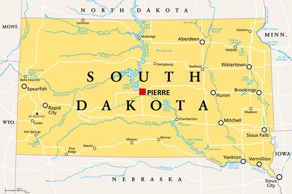
South Dakota, SD, Political Map, With Capital Pierre, And Largest City Sioux Falls. State In The Upper Midwestern Subregion Of The United States Of America, Nicknamed The Mount Rushmore State. Vector.

Vector, 3.62MB, 9000 × 5999 eps
stock vector South Dakota County Map

South Dakota County Map

Vector, 0.85MB, 5000 × 3333 ai
stock vector Russell County in Alabama USA

Russell County In Alabama USA

Vector, 1.2MB, 4167 × 5000 ai
stock image Milwaukee Mitchell International Airport - 3D model aerial rendering

Milwaukee Mitchell International Airport - 3D Model Aerial Rendering

Image, 1.3MB, 3840 × 2160 jpg
stock image Map of Mitchell County in Georgia state on white background. single County map highlighted by black colour on Georgia map. UNITED STATES, US

Map Of Mitchell County In Georgia State On White Background. Single County Map Highlighted By Black Colour On Georgia Map. UNITED STATES, US

Image, 6.56MB, 8000 × 8000 jpg
stock image Map of Mitchell County in Texas state on white background. single County map highlighted by black colour on Texas map. UNITED STATES, US

Map Of Mitchell County In Texas State On White Background. Single County Map Highlighted By Black Colour On Texas Map. UNITED STATES, US

Image, 6.5MB, 8000 × 8000 jpg
stock vector Mitchell (Victoria) outline map set

Mitchell (Victoria) Outline Map Set

Vector, 1.36MB, 6000 × 3000 eps
stock image Map of Mitchell County in North Carolina state on white background. single County map highlighted by black color on North Carolina map. UNITED STATES, US

Map Of Mitchell County In North Carolina State On White Background. Single County Map Highlighted By Black Color On North Carolina Map. UNITED STATES, US

Image, 4.32MB, 8000 × 5334 jpg
Page 1 >> Next