photo free
Home Images Vectors Videos

Stock image Pulaski

stock vector Count Kazimierz Pulaski, 1745-1779, he was a Polish nobleman, soldier and military commander, vintage line drawing or engraving illustration

Count Kazimierz Pulaski, 1745-1779, He Was A Polish Nobleman, Soldier And Military Commander, Vintage Line Drawing Or Engraving Illustration

Vector, 4.88MB, 7806 × 7976 eps
stock image Fire Fighting Tools

Fire Fighting Tools

Image, 11.58MB, 4288 × 2848 jpg
stock image Historic Cockspur LIghthouse

Historic Cockspur LIghthouse

Image, 1MB, 3872 × 2592 jpg
stock image Map of Pulaski County in Illinois state on white background. single County map highlighted by black colour on Illinois map. UNITED STATES, US

Map Of Pulaski County In Illinois State On White Background. Single County Map Highlighted By Black Colour On Illinois Map. UNITED STATES, US

Image, 5.19MB, 8000 × 8000 jpg
stock vector General Pulaski Memorial Day. Suitable for greeting card, poster and banner. Vector illustration.

General Pulaski Memorial Day. Suitable For Greeting Card, Poster And Banner. Vector Illustration.

Vector, 5.25MB, 7501 × 2500 eps
stock image Fort Pulaski

Fort Pulaski

Image, 4.07MB, 2060 × 3111 jpg
stock image Walls of Fort Pulaski

Walls Of Fort Pulaski

Image, 8.53MB, 4620 × 2635 jpg
stock image Tree at Sunrise on Tybee Island

Tree At Sunrise On Tybee Island

Image, 10.98MB, 5387 × 3596 jpg
stock image Pulaski Bridge Bike Path

Pulaski Bridge Bike Path

Image, 6.28MB, 4200 × 2800 jpg
stock vector Vector illustration of the Welcome to Little Rock Arkansas Capital City road sign

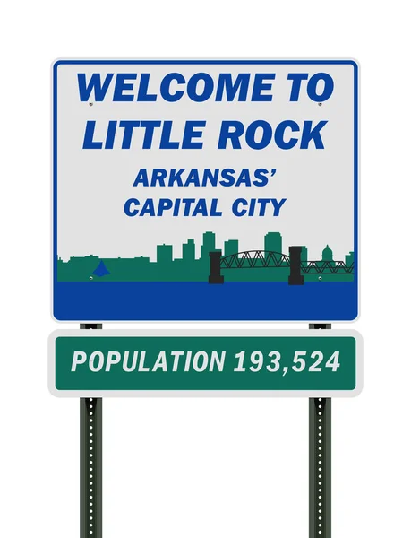
Vector Illustration Of The Welcome To Little Rock Arkansas Capital City Road Sign

Vector, 0.74MB, 6507 × 8500 ai
stock image Sandhill cranes fly in a skein formation across a storm cloud filled sky.

Sandhill Cranes Fly In A Skein Formation Across A Storm Cloud Filled Sky.

Image, 5.51MB, 5394 × 3034 jpg
stock vector General Pulaski Memorial Day wallpaper with shapes and typography, banner, card, poster, template. General Pulaski Memorial Day, background

General Pulaski Memorial Day Wallpaper With Shapes And Typography, Banner, Card, Poster, Template. General Pulaski Memorial Day, Background

Vector, 5.31MB, 4961 × 3508 eps
stock image Civil war cannon

Civil War Cannon

Image, 1.94MB, 3008 × 2000 jpg
stock image Kearny Power Station and Pulasky Skyway

Kearny Power Station And Pulasky Skyway

Image, 5.89MB, 4170 × 2346 jpg
stock image Sandhill cranes fly across a storm cloud filled sky.

Sandhill Cranes Fly Across A Storm Cloud Filled Sky.

Image, 3.23MB, 3600 × 2400 jpg
stock image Brooklyn, New York,USA - November 3. 2019: Marathon runners on Pulaski Bridge on the way from Brooklyn to Queens. Crowded bridge in NYC

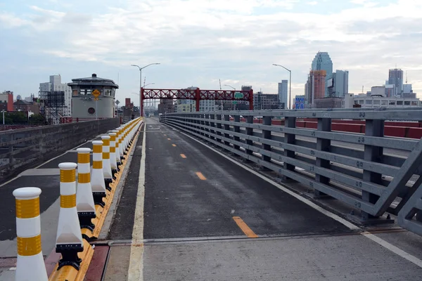
Brooklyn, New York,USA - November 3. 2019: Marathon Runners On Pulaski Bridge On The Way From Brooklyn To Queens. Crowded Bridge In NYC

Image, 15.46MB, 7952 × 5304 jpg
stock image Sandhill cranes at sunset

Sandhill Cranes At Sunset

Image, 4.41MB, 4272 × 2848 jpg
stock vector Arkansas, U.S. state, political map with borders and county names. State in the West South Central region of the Southern United States, subdivided into 75 counties, nicknamed The Natural State.

Arkansas, U.S. State, Political Map With Borders And County Names. State In The West South Central Region Of The Southern United States, Subdivided Into 75 Counties, Nicknamed The Natural State.

Vector, 3.42MB, 6000 × 6000 eps
stock image Map of Pulaski County in Virginia state on white background. single County map highlighted by black colour on Virginia map. UNITED STATES, US

Map Of Pulaski County In Virginia State On White Background. Single County Map Highlighted By Black Colour On Virginia Map. UNITED STATES, US

Image, 4.45MB, 8000 × 5334 jpg
stock image Tourist walking to Fort Pulaski

Tourist Walking To Fort Pulaski

Image, 11.31MB, 5020 × 3347 jpg
stock image Fort Pulaski

Fort Pulaski

Image, 12.05MB, 4998 × 3332 jpg
stock image Draw Bridge at Fort Pulaski

Draw Bridge At Fort Pulaski

Image, 13.81MB, 6016 × 4016 jpg
stock image Cannons in Fort Pulaski, Georgia

Cannons In Fort Pulaski, Georgia

Image, 7.01MB, 4300 × 2867 jpg
stock image Sandhill cranes at sunset

Sandhill Cranes At Sunset

Image, 4.35MB, 4272 × 2848 jpg
stock image Fort Pulaski

Fort Pulaski

Image, 8.32MB, 3600 × 5400 jpg
stock image Tourist in Fort Pulaski

Tourist In Fort Pulaski

Image, 9MB, 3347 × 5020 jpg
stock image Fort Pulaski

Fort Pulaski

Image, 9.69MB, 3413 × 5120 jpg
stock image Fort Pulaski

Fort Pulaski

Image, 7.67MB, 4368 × 2912 jpg
stock image Cannon Aiming Through Wall

Cannon Aiming Through Wall

Image, 5.23MB, 3366 × 3366 jpg
stock image Fort Pulaski

Fort Pulaski

Image, 11.66MB, 3456 × 5184 jpg
stock image Fort Pulaski

Fort Pulaski

Image, 5.12MB, 3072 × 2048 jpg
stock image Fort Pulaski Parade Grounds

Fort Pulaski Parade Grounds

Image, 13.01MB, 5184 × 3456 jpg
stock image Pinnacle Mountain in Arkansas

Pinnacle Mountain In Arkansas

Image, 10.98MB, 3264 × 4928 jpg
stock image Pulaski Square in Cleveland

Pulaski Square In Cleveland

Image, 7.54MB, 5020 × 3347 jpg
stock image Little Rock, Arkansas, USA skyline on the Arkansas River at dusk.

Little Rock, Arkansas, USA Skyline On The Arkansas River At Dusk.

Image, 15.58MB, 6600 × 4405 jpg
stock image Old war cannon closeup in Fort Pulaski, Georgia.

Old War Cannon Closeup In Fort Pulaski, Georgia.

Image, 7.92MB, 3648 × 5472 jpg
stock image Brick Arches in Fort Pulaski

Brick Arches In Fort Pulaski

Image, 4.91MB, 2384 × 3561 jpg
stock image Hawkinsville, Georgia, USA - April 19, 2022: Plaque tells the history of the Pulaski County

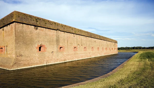
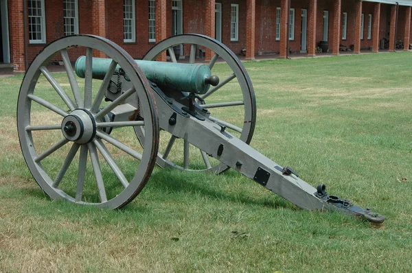
Hawkinsville, Georgia, USA - April 19, 2022: Plaque Tells The History Of The Pulaski County

Image, 26MB, 8192 × 5464 jpg
stock image Map of Pulaski County in Georgia state on white background. single County map highlighted by black colour on Georgia map. UNITED STATES, US

Map Of Pulaski County In Georgia State On White Background. Single County Map Highlighted By Black Colour On Georgia Map. UNITED STATES, US

Image, 6.56MB, 8000 × 8000 jpg
stock image Pulaski Engine 1112 Firetruck Close up

Pulaski Engine 1112 Firetruck Close Up

Image, 4.07MB, 4272 × 2848 jpg
stock image Sandhill cranes fly across a white background.

Sandhill Cranes Fly Across A White Background.

Image, 0.85MB, 3267 × 2178 jpg
stock image Arches in Southern Fort

Arches In Southern Fort

Image, 5.69MB, 2592 × 3872 jpg
stock image Barrel Vaulted Ceiling

Barrel Vaulted Ceiling

Image, 11.64MB, 6016 × 4016 jpg
stock image Fort Pulaski

Fort Pulaski

Image, 9.1MB, 4300 × 2867 jpg
stock vector Arkansas, U.S. state, gray political map with borders and county names. State in the West South Central region of the Southern United States, subdivided into 75 counties. Nicknamed The Natural State.

Arkansas, U.S. State, Gray Political Map With Borders And County Names. State In The West South Central Region Of The Southern United States, Subdivided Into 75 Counties. Nicknamed The Natural State.

Vector, 3.14MB, 6623 × 6000 eps
stock image Prairie Nest

Prairie Nest

Image, 6.39MB, 3086 × 4629 jpg
stock image Little Rock, Arkansas, USA skyline on the Arkansas River at dusk.

Little Rock, Arkansas, USA Skyline On The Arkansas River At Dusk.

Image, 22.11MB, 6600 × 4405 jpg
stock image Little Rock, Arkansas, USA skyline on the Arkansas River at dusk.

Little Rock, Arkansas, USA Skyline On The Arkansas River At Dusk.

Image, 26.42MB, 7360 × 4912 jpg
stock image Ramstein, Germany: Ramstein Air Base PAX Passenger terminal. American and German flags hang in the main gateway for the Kaiserslautern Military Community of Americans living in Germany.

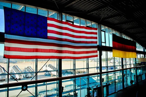
Ramstein, Germany: Ramstein Air Base PAX Passenger Terminal. American And German Flags Hang In The Main Gateway For The Kaiserslautern Military Community Of Americans Living In Germany.

Image, 1.98MB, 3872 × 2592 jpg
stock vector Arkansas, U.S. state, subdivided into 75 counties, multi colored political map with capital Little Rock, borders and county names. State in the West South Central region of the Southern United States.

Arkansas, U.S. State, Subdivided Into 75 Counties, Multi Colored Political Map With Capital Little Rock, Borders And County Names. State In The West South Central Region Of The Southern United States.

Vector, 3.16MB, 6623 × 6000 eps
Page 1 >> Next