photo free
Home Images Vectors Videos

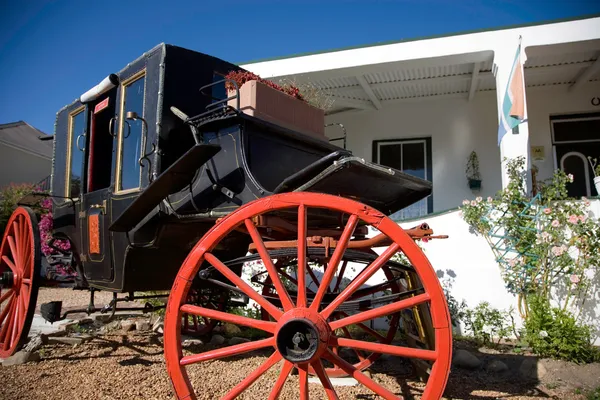
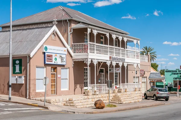
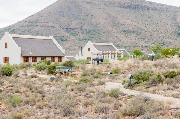
Stock image Western Cape Province

stock image Old horses carriage in Franschhoek

Old Horses Carriage In Franschhoek

Image, 7.76MB, 4368 × 2912 jpg
stock image Street scene in Beaufort Wes

Street Scene In Beaufort Wes

Image, 4.29MB, 3011 × 2000 jpg
stock image Close up of an Ostrich Foot at an Ostrich Farm in Oudtshoorn in the semi desert Little Karoo Region Western Cape Province of South Africa

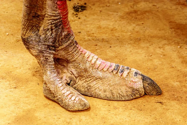
Close Up Of An Ostrich Foot At An Ostrich Farm In Oudtshoorn In The Semi Desert Little Karoo Region Western Cape Province Of South Africa

Image, 11.86MB, 4839 × 3226 jpg
stock image Fossil trail in the Karoo National Park

Fossil Trail In The Karoo National Park

Image, 5.63MB, 3162 × 2100 jpg
stock image Muizenberg station on a rainy day

Muizenberg Station On A Rainy Day

Image, 3.96MB, 2100 × 3162 jpg
stock image Rock formations at Truitjieskraal in the Cederberg Mountains of the Western Cape Province

Rock Formations At Truitjieskraal In The Cederberg Mountains Of The Western Cape Province

Image, 8.4MB, 2400 × 3595 jpg
stock image The main Stadsaal Cave in the Cederberg Mountains in the Western Cape Province of South Africa

The Main Stadsaal Cave In The Cederberg Mountains In The Western Cape Province Of South Africa

Image, 7.78MB, 3595 × 2400 jpg
stock image New Apostolic Church at Matjiesrivier

New Apostolic Church At Matjiesrivier

Image, 6.5MB, 3595 × 2400 jpg
stock image Ruin in Zoar

Ruin In Zoar

Image, 7.94MB, 3595 × 2400 jpg
stock image Klipspringer pass in the Karoo National Park

Klipspringer Pass In The Karoo National Park

Image, 7.97MB, 3613 × 2400 jpg
stock image VELDDRIF, SOUTH AFRICA, AUGUST 22, 2018: A view of a supermarket and liquor store next to road R399 at Die Plaat in Velddrif in the Western Cape Province

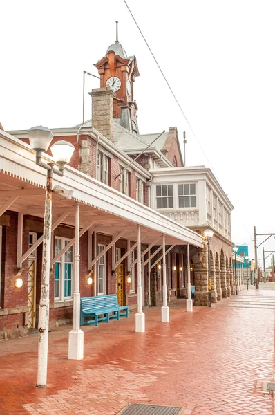
VELDDRIF, SOUTH AFRICA, AUGUST 22, 2018: A View Of A Supermarket And Liquor Store Next To Road R399 At Die Plaat In Velddrif In The Western Cape Province

Image, 4.39MB, 3536 × 2400 jpg
stock image A dramatic vertical dune landscape taken on a cloudy stormy afternoon in Arniston, South Africa. The sand on the top of the peak was being blown by the strong wind.

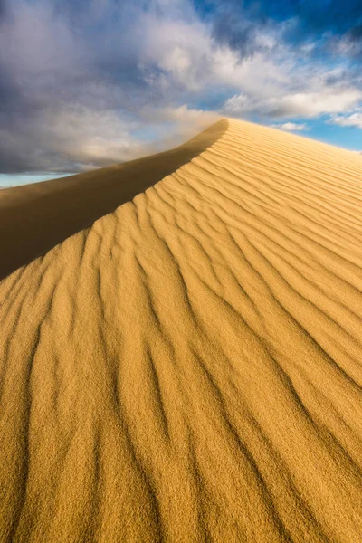
A Dramatic Vertical Dune Landscape Taken On A Cloudy Stormy Afternoon In Arniston, South Africa. The Sand On The Top Of The Peak Was Being Blown By The Strong Wind.

Image, 31.22MB, 4641 × 6961 jpg
stock image Fruit stall in Calitzdorp

Fruit Stall In Calitzdorp

Image, 6.49MB, 3595 × 2400 jpg
stock image Scenic route R62 between Ladismith and Barrydale

Scenic Route R62 Between Ladismith And Barrydale

Image, 4.8MB, 3146 × 2100 jpg
stock image Trail to the Middelberg Waterfall at Algeria in the wilderness area of the Cederberg Mountains in the Western Cape Province of South Africa

Trail To The Middelberg Waterfall At Algeria In The Wilderness Area Of The Cederberg Mountains In The Western Cape Province Of South Africa

Image, 8.58MB, 3595 × 2400 jpg
stock image CEDERBERG, SOUTH AFRICA, AUGUST 23, 2018: The main Stadsaal Cave in the Cederberg Mountains in the Western Cape Province of South Africa. One person is visible

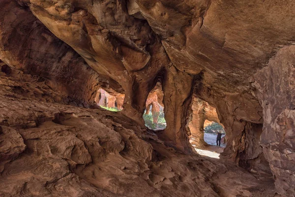
CEDERBERG, SOUTH AFRICA, AUGUST 23, 2018: The Main Stadsaal Cave In The Cederberg Mountains In The Western Cape Province Of South Africa. One Person Is Visible

Image, 6.59MB, 3595 × 2400 jpg
stock image CAPE TOWN, SOUTH AFRICA, AUGUST 17, 2018: Queues of people at the lower cable station at Table mountain in Cape Town in the Western Cape Province. The upper cable station and two cable cars are visible

CAPE TOWN, SOUTH AFRICA, AUGUST 17, 2018: Queues Of People At The Lower Cable Station At Table Mountain In Cape Town In The Western Cape Province. The Upper Cable Station And Two Cable Cars Are Visible

Image, 7.54MB, 3595 × 2400 jpg
stock image Street scene in Franschoek

Street Scene In Franschoek

Image, 4.62MB, 3162 × 2100 jpg
stock image A single lane road bridge, called Borcherds Bridge, the historic Bains Kloof Pass in the Western Cape Province

A Single Lane Road Bridge, Called Borcherds Bridge, The Historic Bains Kloof Pass In The Western Cape Province

Image, 8.15MB, 3595 × 2400 jpg
stock image DWARSKERSBOS, SOUTH AFRICA, AUGUST 21, 2018: A beach scene in Dwarskersbos in the Western Cape Province. Houses and wildflowers are visible

DWARSKERSBOS, SOUTH AFRICA, AUGUST 21, 2018: A Beach Scene In Dwarskersbos In The Western Cape Province. Houses And Wildflowers Are Visible

Image, 7.77MB, 3146 × 2100 jpg
stock image A wild flower landscape at Kromrivier in the Cederberg Mountains of the Western Cape Province

A Wild Flower Landscape At Kromrivier In The Cederberg Mountains Of The Western Cape Province

Image, 9.4MB, 3595 × 2400 jpg
stock image Panoramic view of the Hex River Valley

Panoramic View Of The Hex River Valley

Image, 12.32MB, 8292 × 2100 jpg
stock image WELLINGTON, SOUTH AFRICA, AUGUST 8, 2018: A street scene, with businesses, people and vehicles, in Wellington in the Western Cape Province

WELLINGTON, SOUTH AFRICA, AUGUST 8, 2018: A Street Scene, With Businesses, People And Vehicles, In Wellington In The Western Cape Province

Image, 7.25MB, 3595 × 2400 jpg
stock image A landscape on road R356 to Ceres in the Western Cape Province. Snow is visible on Matroosberg

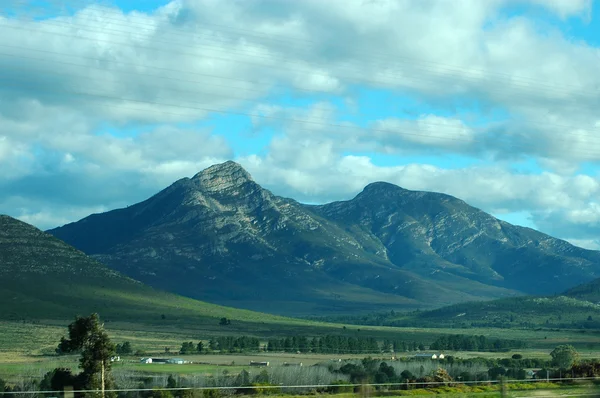
A Landscape On Road R356 To Ceres In The Western Cape Province. Snow Is Visible On Matroosberg

Image, 5.96MB, 3595 × 2400 jpg
stock image Parrot-beaked tortoise (Homopus areolatus)

Parrot-beaked Tortoise (Homopus Areolatus)

Image, 4.1MB, 5791 × 3860 jpg
stock image Parrot-beaked tortoise (Homopus areolatus)

Parrot-beaked Tortoise (Homopus Areolatus)

Image, 7.17MB, 7004 × 4674 jpg
stock image PAARL, SOUTH AFRICA - APRIL 20, 2021: View of the Du Toitskloof Pass on road R101 near Paarl in the Western Cape Province. Vehicles and dead trees are visible

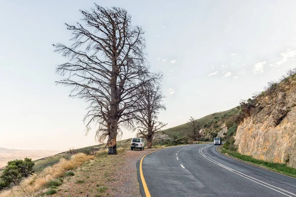
PAARL, SOUTH AFRICA - APRIL 20, 2021: View Of The Du Toitskloof Pass On Road R101 Near Paarl In The Western Cape Province. Vehicles And Dead Trees Are Visible

Image, 6.46MB, 3595 × 2400 jpg
stock image STELLENBOSCH, SOUTH AFRICA, AUGUST 15, 2018: The historic Berghuis (mountain house) in Stellenbosch in the Western Cape Province. Vehicles are visible

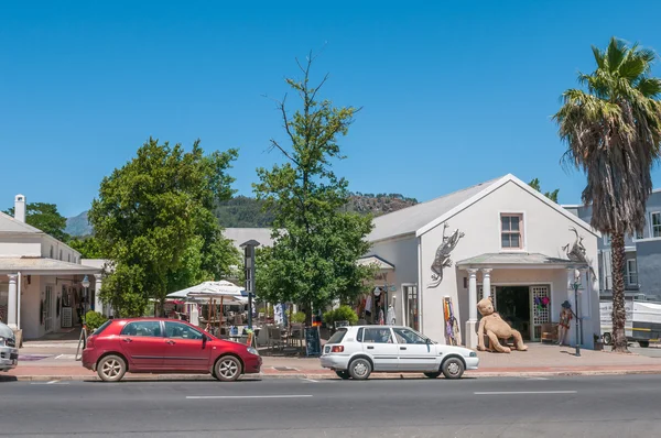
STELLENBOSCH, SOUTH AFRICA, AUGUST 15, 2018: The Historic Berghuis (mountain House) In Stellenbosch In The Western Cape Province. Vehicles Are Visible

Image, 9.19MB, 3595 × 2400 jpg
stock image CAPE TOWN, SOUTH AFRICA, AUGUST 17, 2018: The view down St Georges Street Mall towards St Georges Cathedral in Cape Town in the Western Cape Province. Businesses and people are visible

CAPE TOWN, SOUTH AFRICA, AUGUST 17, 2018: The View Down St Georges Street Mall Towards St Georges Cathedral In Cape Town In The Western Cape Province. Businesses And People Are Visible

Image, 7.1MB, 3146 × 2100 jpg
stock image Outeniqua mountains - South Africa

Outeniqua Mountains - South Africa

Image, 4.11MB, 3008 × 2000 jpg
stock image View of Gobos riverbed at Greyton

View Of Gobos Riverbed At Greyton

Image, 7.8MB, 3595 × 2400 jpg
stock image BAINS KLOOF, SOUTH AFRICA, AUGUST 8, 2018: Dacres Pulpit in the historic Bains Kloof Pass in the Western Cape Province. Vehicles are visible

BAINS KLOOF, SOUTH AFRICA, AUGUST 8, 2018: Dacres Pulpit In The Historic Bains Kloof Pass In The Western Cape Province. Vehicles Are Visible

Image, 6.35MB, 3146 × 2100 jpg
stock image SIMONSTOWN,  SOUTH AFRICA - DEC 23, 2021: A view of the waterfront in Simonstown, Western Cape Province of South Africa. Berthas Restaurant, vehicles and people are visible

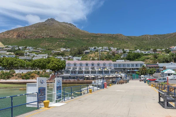
SIMONSTOWN, SOUTH AFRICA - DEC 23, 2021: A View Of The Waterfront In Simonstown, Western Cape Province Of South Africa. Berthas Restaurant, Vehicles And People Are Visible

Image, 6.72MB, 3595 × 2400 jpg
stock image PAARL, SOUTH AFRICA, AUGUST 10, 2018: The goat tower at Fairview wine and cheese farm near Paarl in the Western Cape Province. Goats and people are visible

PAARL, SOUTH AFRICA, AUGUST 10, 2018: The Goat Tower At Fairview Wine And Cheese Farm Near Paarl In The Western Cape Province. Goats And People Are Visible

Image, 6.91MB, 3416 × 2400 jpg
stock image Panorama of the Robinson Pass

Panorama Of The Robinson Pass

Image, 16.26MB, 9255 × 2104 jpg
stock image Afrikaans Language Monument in Paarl

Afrikaans Language Monument In Paarl

Image, 5.25MB, 3613 × 2400 jpg
stock image Railway tunnel at Hex River Pass

Railway Tunnel At Hex River Pass

Image, 10.37MB, 4288 × 2848 jpg
stock image Wild flowers and citrus orchards near Citrusdal

Wild Flowers And Citrus Orchards Near Citrusdal

Image, 7.71MB, 3595 × 2400 jpg
stock image Mossel bay, south africa

Mossel Bay, South Africa

Image, 16.03MB, 5616 × 3744 jpg
stock image The road to Tietiesbaai at Cape Columbine near Paternoster in the Western Cape Province

The Road To Tietiesbaai At Cape Columbine Near Paternoster In The Western Cape Province

Image, 4.91MB, 3595 × 2400 jpg
stock image Dutch Reformed Church, Worcester

Dutch Reformed Church, Worcester

Image, 3.11MB, 3162 × 2100 jpg
stock image Black-headed heron at Sir Lowreys Pass

Black-headed Heron At Sir Lowreys Pass

Image, 3.42MB, 2409 × 1600 jpg
stock image Strand in False Bay. Cape Town

Strand In False Bay. Cape Town

Image, 7.01MB, 4677 × 3118 jpg
stock image The coast on the Atlantic Ocean side of Cape of Good Hope in Cape Point Nature Reserve

The Coast On The Atlantic Ocean Side Of Cape Of Good Hope In Cape Point Nature Reserve

Image, 10.7MB, 5978 × 3363 jpg
stock image Waves rolling on to the shoreline of the Atlantic Ocean coast at Cape of Good Hope

Waves Rolling On To The Shoreline Of The Atlantic Ocean Coast At Cape Of Good Hope

Image, 15.18MB, 5918 × 3329 jpg
stock image The Atlantic coast along the road to Chapman's Peak at the Slangkop Lighthouse in the Cape Peninsula

The Atlantic Coast Along The Road To Chapman's Peak At The Slangkop Lighthouse In The Cape Peninsula

Image, 15.21MB, 5804 × 3265 jpg
stock image Waves rolling on to the shoreline of the Atlantic Ocean coast at Cape of Good Hope

Waves Rolling On To The Shoreline Of The Atlantic Ocean Coast At Cape Of Good Hope

Image, 14.91MB, 5977 × 3362 jpg
stock image Dutch Reformed Church, Rawsonville

Dutch Reformed Church, Rawsonville

Image, 6.82MB, 4288 × 2848 jpg
stock image Panorama of the harbor in Saldanha Bay

Panorama Of The Harbor In Saldanha Bay

Image, 6.47MB, 6274 × 2100 jpg
stock image Panorama of the harbor in Saldanha Bay

Panorama Of The Harbor In Saldanha Bay

Image, 17.19MB, 11391 × 2400 jpg
Page 1 >> Next