photo free
Home Images Vectors Videos

Stock image Bering page 2

stock image Nunivak Island in the Bering Sea, belonging to United States, isolated on a satellite image taken in July 8, 2019, with distance scale

Nunivak Island In The Bering Sea, Belonging To United States, Isolated On A Satellite Image Taken In July 8, 2019, With Distance Scale

Image, 1.53MB, 2160 × 2160 jpg
stock image Herbert Island in the Bering Sea on a topographic, OSM Humanitarian style map

Herbert Island In The Bering Sea On A Topographic, OSM Humanitarian Style Map

Image, 0.25MB, 2880 × 1620 jpg
stock image Little Tanaga Island in the Bering Sea on a topographic, OSM Humanitarian style map

Little Tanaga Island In The Bering Sea On A Topographic, OSM Humanitarian Style Map

Image, 0.58MB, 2880 × 1620 jpg
stock image Gareloi Island in the Bering Sea on a satellite image taken in November 5, 2020

Gareloi Island In The Bering Sea On A Satellite Image Taken In November 5, 2020

Image, 5.02MB, 2880 × 1620 jpg
stock image Attu Island in the Bering Sea, belonging to United States, isolated on a topographic, OSM Humanitarian style map, with distance scale

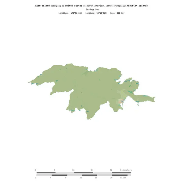
Attu Island In The Bering Sea, Belonging To United States, Isolated On A Topographic, OSM Humanitarian Style Map, With Distance Scale

Image, 0.36MB, 2160 × 2160 jpg
stock image Adak Island in the Bering Sea on a topographic, OSM Humanitarian style map

Adak Island In The Bering Sea On A Topographic, OSM Humanitarian Style Map

Image, 0.85MB, 2880 × 1620 jpg
stock image Little Sitkin Island in the Bering Sea on a colored elevation map

Little Sitkin Island In The Bering Sea On A Colored Elevation Map

Image, 1MB, 2880 × 1620 jpg
stock image Great Sitkin Island in the Bering Sea - belonging to United States. Described location diagram with yellow shape of the island and sample maps of its surroundings

Great Sitkin Island In The Bering Sea - Belonging To United States. Described Location Diagram With Yellow Shape Of The Island And Sample Maps Of Its Surroundings

Image, 2.33MB, 3840 × 2160 jpg
stock image Seguam Island in the Bering Sea, belonging to United States, isolated on a topographic, OSM Humanitarian style map, with distance scale

Seguam Island In The Bering Sea, Belonging To United States, Isolated On A Topographic, OSM Humanitarian Style Map, With Distance Scale

Image, 0.26MB, 2160 × 2160 jpg
stock image Chuginadak Island in the Bering Sea, belonging to United States, isolated on a satellite image taken in November 19, 2017, with distance scale

Chuginadak Island In The Bering Sea, Belonging To United States, Isolated On A Satellite Image Taken In November 19, 2017, With Distance Scale

Image, 1.39MB, 2160 × 2160 jpg
stock image Buldir Island in the Bering Sea, belonging to United States, isolated on a satellite image taken in November 11, 2020, with distance scale

Buldir Island In The Bering Sea, Belonging To United States, Isolated On A Satellite Image Taken In November 11, 2020, With Distance Scale

Image, 1.13MB, 2160 × 2160 jpg
stock image Adak Island in the Bering Sea - belonging to United States. Described location diagram with yellow shape of the island and sample maps of its surroundings

Adak Island In The Bering Sea - Belonging To United States. Described Location Diagram With Yellow Shape Of The Island And Sample Maps Of Its Surroundings

Image, 14.27MB, 11520 × 6480 jpg
stock image Akun Island in the Bering Sea, belonging to United States, isolated on a satellite image taken in June 18, 2021, with distance scale

Akun Island In The Bering Sea, Belonging To United States, Isolated On A Satellite Image Taken In June 18, 2021, With Distance Scale

Image, 1.4MB, 2160 × 2160 jpg
stock image High Island in the Bering Sea, belonging to United States, isolated on a bilevel elevation map, with distance scale

High Island In The Bering Sea, Belonging To United States, Isolated On A Bilevel Elevation Map, With Distance Scale

Image, 0.27MB, 2160 × 2160 jpg
stock image Amlia Island in the Bering Sea, belonging to United States, isolated on a satellite image taken in January 18, 2024, with distance scale

Amlia Island In The Bering Sea, Belonging To United States, Isolated On A Satellite Image Taken In January 18, 2024, With Distance Scale

Image, 0.6MB, 2160 × 2160 jpg
stock image Atka Island in the Bering Sea, belonging to United States, isolated on a satellite image taken in June 17, 2023, with distance scale

Atka Island In The Bering Sea, Belonging To United States, Isolated On A Satellite Image Taken In June 17, 2023, With Distance Scale

Image, 0.66MB, 2160 × 2160 jpg
stock image Chugul Island in the Bering Sea, belonging to United States, isolated on a satellite image taken in October 28, 2023, with distance scale

Chugul Island In The Bering Sea, Belonging To United States, Isolated On A Satellite Image Taken In October 28, 2023, With Distance Scale

Image, 0.96MB, 2160 × 2160 jpg
stock image Kagamil Island in the Bering Sea, belonging to United States, isolated on a topographic, OSM Humanitarian style map, with distance scale

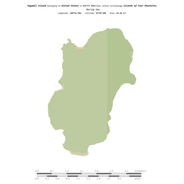
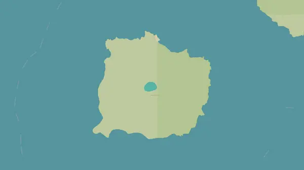
Kagamil Island In The Bering Sea, Belonging To United States, Isolated On A Topographic, OSM Humanitarian Style Map, With Distance Scale

Image, 0.27MB, 2160 × 2160 jpg
stock image Seguam Island in the Bering Sea on a satellite image taken in July 19, 2023

Seguam Island In The Bering Sea On A Satellite Image Taken In July 19, 2023

Image, 3.83MB, 2880 × 1620 jpg
stock image Gareloi Island in the Bering Sea on a bilevel elevation map

Gareloi Island In The Bering Sea On A Bilevel Elevation Map

Image, 0.35MB, 2880 × 1620 jpg
stock image Strawberry Bloom

Strawberry Bloom

Image, 11MB, 5616 × 3744 jpg
stock image Sandpiper bird on a rock

Sandpiper Bird On A Rock

Image, 5.16MB, 3944 × 2376 jpg
stock image Iron beach 2

Iron Beach 2

Image, 2.79MB, 2592 × 1728 jpg
stock image black-legged kittiwake adult and two chicks in the nest on a cli

Black-legged Kittiwake Adult And Two Chicks In The Nest On A Cli

Image, 6.6MB, 5184 × 3456 jpg
stock image young grey-tailed tattler which stands on a rock by the ocean

Young Grey-tailed Tattler Which Stands On A Rock By The Ocean

Image, 7.69MB, 5184 × 3456 jpg
stock image gray-crowned rosy finch on the Commander Islands winter day

Gray-crowned Rosy Finch On The Commander Islands Winter Day

Image, 7.15MB, 5184 × 3456 jpg
stock vector Alaska - vector map

Alaska - Vector Map

Vector, 0.61MB, 4043 × 3327 eps
stock vector Vector set of seamless Yakut national ornaments. monochrome endless asian patterns, bodices and frames. Home decorations, carpets and ceramics. Traditions of northern peoples, people of the tundra

Vector Set Of Seamless Yakut National Ornaments. Monochrome Endless Asian Patterns, Bodices And Frames. Home Decorations, Carpets And Ceramics. Traditions Of Northern Peoples, People Of The Tundra

Vector, 16.62MB, 9450 × 5549 eps
stock image Detailed Earth. Chukotka, Alaska and the Bering Strait

Detailed Earth. Chukotka, Alaska And The Bering Strait

Image, 7.32MB, 5000 × 5000 jpg
stock vector vector map of the russian far east region Kamchatka.

Vector Map Of The Russian Far East Region Kamchatka.

Vector, 1.04MB, 3100 × 4002 eps
stock image Clutch disc kit car on a white background

Clutch Disc Kit Car On A White Background

Image, 6.49MB, 5962 × 3975 jpg
stock image View on ocean from mountain pass 2

View On Ocean From Mountain Pass 2

Image, 3.31MB, 3001 × 2000 jpg
stock vector US State Alaska Political Map and map icons

US State Alaska Political Map And Map Icons

Vector, 13.96MB, 4911 × 4455 eps
stock image Pollock on white background

Pollock On White Background

Image, 3.24MB, 5472 × 3648 jpg
stock image Unalaska Island in the Bering Sea, belonging to United States, isolated on a satellite image taken in September 9, 2020, with distance scale

Unalaska Island In The Bering Sea, Belonging To United States, Isolated On A Satellite Image Taken In September 9, 2020, With Distance Scale

Image, 1.28MB, 2160 × 2160 jpg
stock image Crooked Island in the Bering Sea on a satellite image taken in June 16, 2024

Crooked Island In The Bering Sea On A Satellite Image Taken In June 16, 2024

Image, 2.95MB, 2880 × 1620 jpg
stock image Yunaska Island in the Bering Sea - belonging to United States. Described location diagram with yellow shape of the island and sample maps of its surroundings

Yunaska Island In The Bering Sea - Belonging To United States. Described Location Diagram With Yellow Shape Of The Island And Sample Maps Of Its Surroundings

Image, 1.94MB, 3840 × 2160 jpg
stock image Agattu Island in the Bering Sea, belonging to United States, isolated on a bilevel elevation map, with distance scale

Agattu Island In The Bering Sea, Belonging To United States, Isolated On A Bilevel Elevation Map, With Distance Scale

Image, 0.45MB, 2160 × 2160 jpg
stock image Avatanak Island in the Bering Sea - belonging to United States. Described location diagram with yellow shape of the island and sample maps of its surroundings

Avatanak Island In The Bering Sea - Belonging To United States. Described Location Diagram With Yellow Shape Of The Island And Sample Maps Of Its Surroundings

Image, 2.19MB, 3840 × 2160 jpg
stock image Avatanak Island in the Bering Sea, belonging to United States, isolated on a bilevel elevation map, with distance scale

Avatanak Island In The Bering Sea, Belonging To United States, Isolated On A Bilevel Elevation Map, With Distance Scale

Image, 0.27MB, 2160 × 2160 jpg
stock image Chugul Island in the Bering Sea - belonging to United States. Described location diagram with yellow shape of the island and sample maps of its surroundings

Chugul Island In The Bering Sea - Belonging To United States. Described Location Diagram With Yellow Shape Of The Island And Sample Maps Of Its Surroundings

Image, 2.09MB, 3840 × 2160 jpg
stock image Little Sitkin Island in the Bering Sea, belonging to United States, isolated on a bilevel elevation map, with distance scale

Little Sitkin Island In The Bering Sea, Belonging To United States, Isolated On A Bilevel Elevation Map, With Distance Scale

Image, 0.4MB, 2160 × 2160 jpg
stock image Unalga Island in the Bering Sea, belonging to United States, isolated on a bilevel elevation map, with distance scale

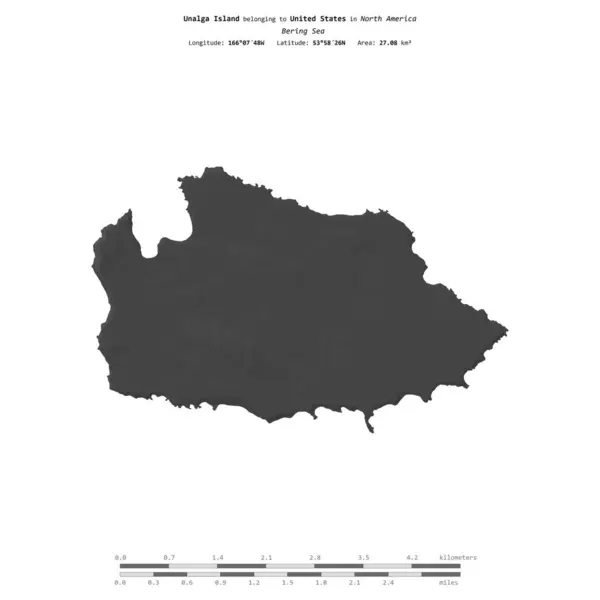
Unalga Island In The Bering Sea, Belonging To United States, Isolated On A Bilevel Elevation Map, With Distance Scale

Image, 0.29MB, 2160 × 2160 jpg
stock image High Island in the Bering Sea on a topographic, OSM Humanitarian style map

High Island In The Bering Sea On A Topographic, OSM Humanitarian Style Map

Image, 0.21MB, 2880 × 1620 jpg
stock image Kiska Island in the Bering Sea on a topographic, OSM Humanitarian style map

Kiska Island In The Bering Sea On A Topographic, OSM Humanitarian Style Map

Image, 0.42MB, 2880 × 1620 jpg
stock image Crooked Island in the Bering Sea on a topographic, OSM Humanitarian style map

Crooked Island In The Bering Sea On A Topographic, OSM Humanitarian Style Map

Image, 0.22MB, 2880 × 1620 jpg
stock image Segula Island in the Bering Sea on a topographic, OSM Humanitarian style map

Segula Island In The Bering Sea On A Topographic, OSM Humanitarian Style Map

Image, 0.22MB, 2880 × 1620 jpg
stock image Kagalaska Island in the Bering Sea on a satellite image taken in September 24, 2019

Kagalaska Island In The Bering Sea On A Satellite Image Taken In September 24, 2019

Image, 5.59MB, 2880 × 1620 jpg
stock image Tanaga Island in the Bering Sea on a satellite image taken in September 13, 2021

Tanaga Island In The Bering Sea On A Satellite Image Taken In September 13, 2021

Image, 3.82MB, 2880 × 1620 jpg
stock image Tigalda Island in the Bering Sea on a colored elevation map

Tigalda Island In The Bering Sea On A Colored Elevation Map

Image, 0.88MB, 2880 × 1620 jpg
Previous << Page 2 >> Next