photo free
Home Images Vectors Videos

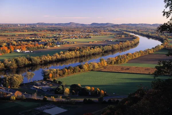
Stock image Connecticut River

stock image Farmland In Massachusetts

Farmland In Massachusetts

Image, 6.97MB, 5601 × 3745 jpg
stock image Hartford, Connecticut, USA

Hartford, Connecticut, USA

Image, 18.99MB, 6000 × 4004 jpg
stock image Hartford City Skyline

Hartford City Skyline

Image, 17.81MB, 7360 × 4912 jpg
stock image Scenic early morning fog just above the water level of Connecticut River with colorful fall foliage along both sides converging into distance.

Scenic Early Morning Fog Just Above The Water Level Of Connecticut River With Colorful Fall Foliage Along Both Sides Converging Into Distance.

Image, 7.85MB, 5700 × 3800 jpg
stock image Beautiful Connecticut River lined by autumn foliage forest with jetty and oak tree in foreground near Brattlebro, Vermont  USA.

Beautiful Connecticut River Lined By Autumn Foliage Forest With Jetty And Oak Tree In Foreground Near Brattlebro, Vermont USA.

Image, 18.52MB, 5700 × 3800 jpg
stock image Autumn colors across Connecticut River in New Hampshire viewed from Stafford, Vermont

Autumn Colors Across Connecticut River In New Hampshire Viewed From Stafford, Vermont

Image, 3.76MB, 4572 × 2114 jpg
stock image Indian Pond in Madame Sherri Forest in New Hampshire

Indian Pond In Madame Sherri Forest In New Hampshire

Image, 16.25MB, 6000 × 4000 jpg
stock image Downtown Hartford, Connecticut Skyline seen in Summer by Drone

Downtown Hartford, Connecticut Skyline Seen In Summer By Drone

Image, 6.97MB, 4862 × 3646 jpg
stock image The Bulkeley Bridge over the Connecticut River, in Hartford, Con

The Bulkeley Bridge Over The Connecticut River, In Hartford, Con

Image, 5.89MB, 3800 × 2533 jpg
stock image Hartford, Connecticut

Hartford, Connecticut

Image, 17.78MB, 5500 × 3666 jpg
stock image Hartford skyline and Founders Bridge

Hartford Skyline And Founders Bridge

Image, 8.06MB, 5760 × 3840 jpg
stock vector Connecticut, political map with capital Hartford. State of Connecticut, CT, the southernmost state in the New England region of the northeastern United States of America. English. Illustration. Vector

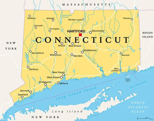
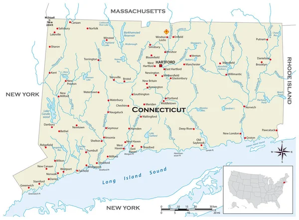
Connecticut, Political Map With Capital Hartford. State Of Connecticut, CT, The Southernmost State In The New England Region Of The Northeastern United States Of America. English. Illustration. Vector

Vector, 3.45MB, 7581 × 6000 eps
stock image View of the Connecticut River From Brattleboro Vermont State Lin

View Of The Connecticut River From Brattleboro Vermont State Lin

Image, 18.39MB, 6000 × 4000 jpg
stock image Bridge over the Connecticut River, in Brattleboro, Vermont.

Bridge Over The Connecticut River, In Brattleboro, Vermont.

Image, 20.76MB, 5843 × 3895 jpg
stock image View of the Connecticut River From Brattleboro Vermont State Lin

View Of The Connecticut River From Brattleboro Vermont State Lin

Image, 21.96MB, 6000 × 4000 jpg
stock image Ferry Park in Rocky Hill, CT at Sunrise

Ferry Park In Rocky Hill, CT At Sunrise

Image, 5.01MB, 5964 × 3978 jpg
stock image Scenic Early morning fog just above the water level of Connecticut River with colorful fall foliage reflected in calm water.

Scenic Early Morning Fog Just Above The Water Level Of Connecticut River With Colorful Fall Foliage Reflected In Calm Water.

Image, 8.29MB, 5700 × 3856 jpg
stock image Jetty on edge of Connecticut River in Vermont USA.

Jetty On Edge Of Connecticut River In Vermont USA.

Image, 16.91MB, 6048 × 3512 jpg
stock image Skyline of downtown Hartford, Connecticut from above Charter Oak Landing at sunset.

Skyline Of Downtown Hartford, Connecticut From Above Charter Oak Landing At Sunset.

Image, 9.38MB, 4200 × 2800 jpg
stock image Skyline of downtown Hartford, Connecticut from above Charter Oak Landing at sunset.

Skyline Of Downtown Hartford, Connecticut From Above Charter Oak Landing At Sunset.

Image, 10.01MB, 4200 × 2800 jpg
stock image Springfield, Massachusetts Skyline

Springfield, Massachusetts Skyline

Image, 15.07MB, 6000 × 4004 jpg
stock image Jetty on edge of Connecticut River in Vermont USA.

Jetty On Edge Of Connecticut River In Vermont USA.

Image, 13.16MB, 5846 × 3849 jpg
stock image Mountains and a lake near Brattleboro, Vermont.

Mountains And A Lake Near Brattleboro, Vermont.

Image, 14.81MB, 5923 × 3949 jpg
stock image Springfield, Massachusetts, USA downtown skyline

Springfield, Massachusetts, USA Downtown Skyline

Image, 22.56MB, 7360 × 4912 jpg
stock image Hartford Connecticut Skyline

Hartford Connecticut Skyline

Image, 10.83MB, 5184 × 3456 jpg
stock image Springfield, Massachusetts, USA

Springfield, Massachusetts, USA

Image, 17.57MB, 6000 × 4004 jpg
stock image Springfield, Massachusetts, United States- November 11, 2021: An aerial view of the Naismith Memorial Basketball Hall of Fame, Springfield, Massachusetts

Springfield, Massachusetts, United States- November 11, 2021: An Aerial View Of The Naismith Memorial Basketball Hall Of Fame, Springfield, Massachusetts

Image, 11.22MB, 5472 × 3648 jpg
stock image Cornish Windsor Covered Bridge

Cornish Windsor Covered Bridge

Image, 16.01MB, 5472 × 3648 jpg
stock image Springfield, Massachusetts, USA downtown skyline

Springfield, Massachusetts, USA Downtown Skyline

Image, 12.39MB, 7360 × 3153 jpg
stock image Springfield, Massachusetts, USA

Springfield, Massachusetts, USA

Image, 13.07MB, 6600 × 3713 jpg
stock image An overcast day over Hartford Connecticut and the urban city center landscape

An Overcast Day Over Hartford Connecticut And The Urban City Center Landscape

Image, 9.61MB, 5385 × 2892 jpg
stock image Springfield, Massachusetts, USA downtown skyline

Springfield, Massachusetts, USA Downtown Skyline

Image, 19.12MB, 7360 × 4912 jpg
stock image Downtown Hartford, Connecticut Skyline seen in Summer by Drone

Downtown Hartford, Connecticut Skyline Seen In Summer By Drone

Image, 7.02MB, 4862 × 3646 jpg
stock image Springfield, Massachussetts, USA Skyline

Springfield, Massachussetts, USA Skyline

Image, 19.3MB, 6600 × 4405 jpg
stock image Hartford Connecticut Skyline At Night

Hartford Connecticut Skyline At Night

Image, 7.05MB, 4787 × 3191 jpg
stock image hartford connecticut commute at sunset long exposure

Hartford Connecticut Commute At Sunset Long Exposure

Image, 10.73MB, 8000 × 3865 jpg
stock image Scenic river edge and T-shaped pier under oak tree early morning fog just above the water level of Connecticut River with colorful fall foliage along both sides converging into distance.

Scenic River Edge And T-shaped Pier Under Oak Tree Early Morning Fog Just Above The Water Level Of Connecticut River With Colorful Fall Foliage Along Both Sides Converging Into Distance.

Image, 14.97MB, 5700 × 3800 jpg
stock image An aerial vertical of Springfield, Massachusetts, United States by Connecticut River

An Aerial Vertical Of Springfield, Massachusetts, United States By Connecticut River

Image, 3.88MB, 2668 × 4002 jpg
stock image Yachts in a Harbor along the Connecticut River at Sunset

Yachts In A Harbor Along The Connecticut River At Sunset

Image, 7.28MB, 4078 × 2701 jpg
stock image A historic church in Brattleboro, Vermont.

A Historic Church In Brattleboro, Vermont.

Image, 18.47MB, 5832 × 3888 jpg
stock image A historic church in Brattleboro, Vermont.

A Historic Church In Brattleboro, Vermont.

Image, 20.42MB, 5843 × 3895 jpg
stock image Boats docked at a marina - Cos Cob, Connecticut

Boats Docked At A Marina - Cos Cob, Connecticut

Image, 18.59MB, 6000 × 4000 jpg
stock image Centre Congregational Church in Brattleboro, Vermont.

Centre Congregational Church In Brattleboro, Vermont.

Image, 12.35MB, 5676 × 3784 jpg
stock image Buildings along Main Street, in downtown Brattleboro, Vermont.

Buildings Along Main Street, In Downtown Brattleboro, Vermont.

Image, 14.61MB, 5834 × 3889 jpg
stock image Buildings along Main Street, in downtown Brattleboro, Vermont.

Buildings Along Main Street, In Downtown Brattleboro, Vermont.

Image, 14.01MB, 5955 × 3970 jpg
stock image Graffiti on old buildings in Brattleboro, Vermont.

Graffiti On Old Buildings In Brattleboro, Vermont.

Image, 18.95MB, 5970 × 3980 jpg
stock vector Highly detailed physical map of the US state of Connecticut

Highly Detailed Physical Map Of The US State Of Connecticut

Vector, 1.84MB, 4197 × 3100 eps
stock image View of the Connecticut River From Brattleboro Vermont State Lin

View Of The Connecticut River From Brattleboro Vermont State Lin

Image, 14.22MB, 6000 × 4000 jpg
stock image Hartford skyline and Founders Bridge at sunset

Hartford Skyline And Founders Bridge At Sunset

Image, 22.63MB, 10131 × 2939 jpg
stock image Hartford, Connecticut on Founders Bridge

Hartford, Connecticut On Founders Bridge

Image, 11.28MB, 5200 × 3250 jpg
Page 1 >> Next