photo free
Home Images Vectors Videos

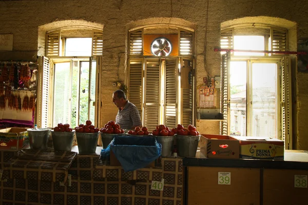
Stock image Georgia Territory

stock vector Georgia state blank outline map

Georgia State Blank Outline Map

Vector, 0.93MB, 4000 × 4800 eps
stock vector Georgia Map Vector Outline Design Template. Editable Stroke.

Georgia Map Vector Outline Design Template. Editable Stroke.

Vector, 0.42MB, 5000 × 5000 eps
stock vector map of the U.S. state of Georgia

Map Of The U.S. State Of Georgia

Vector, 0.72MB, 5000 × 5000 eps
stock vector Georgia geometric polygonal mosaic style us state maps collection Bright abstract tessellation

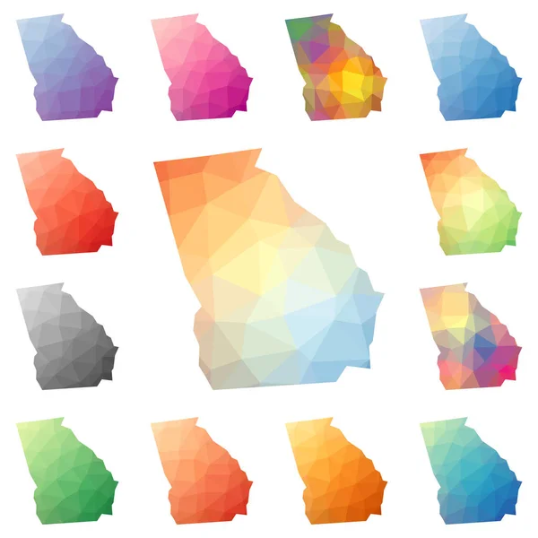
Georgia Geometric Polygonal Mosaic Style Us State Maps Collection Bright Abstract Tessellation

Vector, 0.66MB, 8333 × 8333 eps
stock vector Flag of Georgia. Abstract concept

Flag Of Georgia. Abstract Concept

Vector, 2.11MB, 5000 × 4200 eps
stock vector U.S. state of Georgia

U.S. State Of Georgia

Vector, 0.61MB, 5000 × 5000 eps
stock image Georgia State Flag painted on old wood plank texture

Georgia State Flag Painted On Old Wood Plank Texture

Image, 22.5MB, 5184 × 3456 jpg
stock image In Kazbegi National Park

In Kazbegi National Park

Image, 28.24MB, 7100 × 3187 jpg
stock image Uplistsikhe is an ancient rock-hewn town in eastern Georgia,

Uplistsikhe Is An Ancient Rock-hewn Town In Eastern Georgia,

Image, 11.49MB, 4928 × 3264 jpg
stock image Uplistsikhe is an ancient rock-hewn town in eastern Georgia,

Uplistsikhe Is An Ancient Rock-hewn Town In Eastern Georgia,

Image, 11.02MB, 4928 × 3264 jpg
stock image MOSCOW, RUSSIA JULY 8, 2018: Natural-landscape Park

MOSCOW, RUSSIA JULY 8, 2018: Natural-landscape Park "Zaryadye" In Moscow

Image, 4.06MB, 4928 × 3280 jpg
stock image The territory of the Holy Trinity Cathedral (Tsminda Sameba): th

The Territory Of The Holy Trinity Cathedral (Tsminda Sameba): Th

Image, 2.59MB, 3000 × 2000 jpg
stock vector administrative vector map of the Russian North Caucasian Federal District

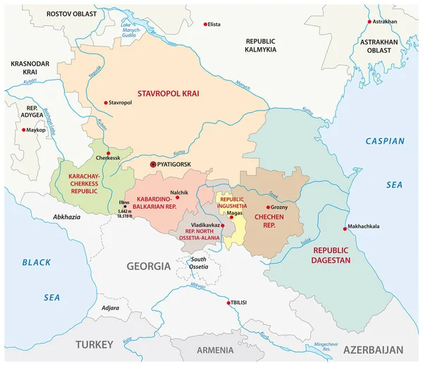
Administrative Vector Map Of The Russian North Caucasian Federal District

Vector, 1MB, 3584 × 3100 eps
stock image Tbilisi, Georgia - October 2018: people in the territory of the Holy Trinity Cathedral commonly known as Sameba in Tbilisi, Georgia

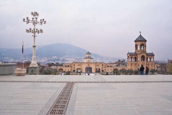
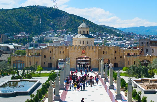
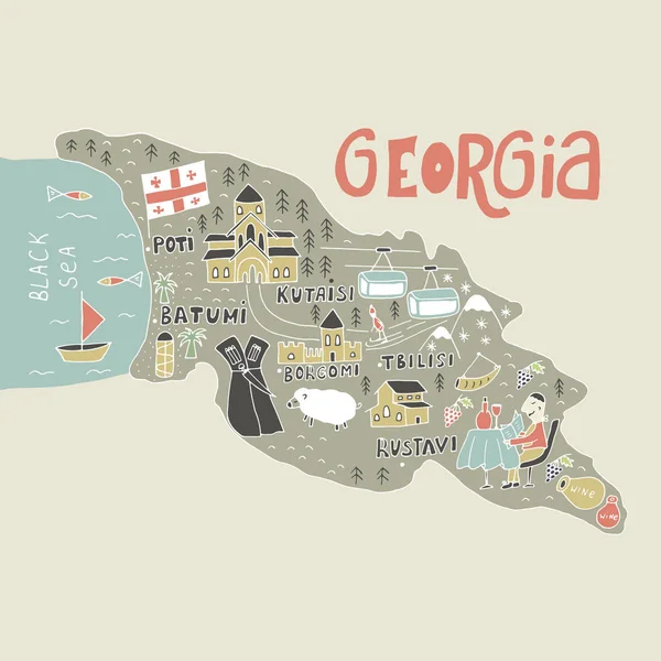
Tbilisi, Georgia - October 2018: People In The Territory Of The Holy Trinity Cathedral Commonly Known As Sameba In Tbilisi, Georgia

Image, 4.98MB, 5933 × 3955 jpg
stock image Uplistsikhe is an ancient rock-hewn town in eastern Georgia,

Uplistsikhe Is An Ancient Rock-hewn Town In Eastern Georgia,

Image, 10.56MB, 4879 × 3232 jpg
stock vector Georgia (country) - vector map

Georgia (country) - Vector Map

Vector, 0.22MB, 5733 × 3709 eps
stock image The mansion in Historic Park

The Mansion In Historic Park

Image, 20.71MB, 5114 × 3998 jpg
stock image Landscape of South Georgia

Landscape Of South Georgia

Image, 26.08MB, 7353 × 4907 jpg
stock image Uplistsikhe is an ancient rock-hewn town in eastern Georgia,

Uplistsikhe Is An Ancient Rock-hewn Town In Eastern Georgia,

Image, 11.16MB, 4880 × 3210 jpg
stock image Landscape of South Georgia

Landscape Of South Georgia

Image, 18.18MB, 7215 × 4059 jpg
stock image Landscape of South Georgia

Landscape Of South Georgia

Image, 20.65MB, 7360 × 4912 jpg
stock vector administrative road map of the metropolitan area of atlanta georgia

Administrative Road Map Of The Metropolitan Area Of Atlanta Georgia

Vector, 1.39MB, 3267 × 3100 eps
stock image Sameba Cathedral. Tbilisi, Georgia

Sameba Cathedral. Tbilisi, Georgia

Image, 7.14MB, 3013 × 1968 jpg
stock vector North America Political Map. Highly detailed map. All elements are separated in editable layers clearly labeled. Vector

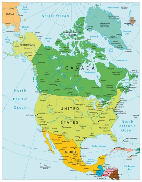
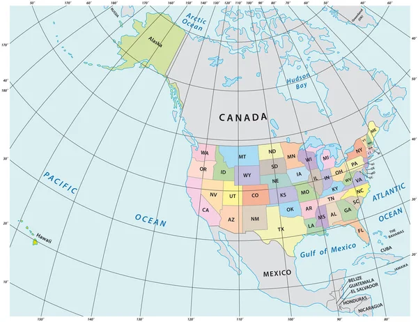
North America Political Map. Highly Detailed Map. All Elements Are Separated In Editable Layers Clearly Labeled. Vector

Vector, 12.15MB, 3767 × 4826 eps
stock vector Contour Georgia map

Contour Georgia Map

Vector, 2.91MB, 7004 × 3705 eps
stock image An unidentified seller

An Unidentified Seller

Image, 7.35MB, 4352 × 2901 jpg
stock vector Unique hand drawn cartoon map of Georgia. Vector illustration

Unique Hand Drawn Cartoon Map Of Georgia. Vector Illustration

Vector, 0.81MB, 5000 × 5000 eps
stock vector Political Map of USSR with Names

Political Map Of USSR With Names

Vector, 0.32MB, 5285 × 3505 ai
stock vector Georgia map

Georgia Map

Vector, 12.24MB, 7000 × 7000 eps
stock image Farmer takes care of plants growing in garden on sunny summer day in countryside. Elderly woman in sun-protective hat holds lush flower pot-plants putting in long rows on territory of country house

Farmer Takes Care Of Plants Growing In Garden On Sunny Summer Day In Countryside. Elderly Woman In Sun-protective Hat Holds Lush Flower Pot-plants Putting In Long Rows On Territory Of Country House

Image, 12.81MB, 5754 × 3836 jpg
stock vector Unique hand drawn cartoon map of Georgia. Vector illustration

Unique Hand Drawn Cartoon Map Of Georgia. Vector Illustration

Vector, 1.12MB, 5000 × 5000 eps
stock vector administrative vector map of the US American State of Georgia

Administrative Vector Map Of The US American State Of Georgia

Vector, 2.55MB, 3100 × 3610 eps
stock image Sale of agricultural products

Sale Of Agricultural Products

Image, 10.27MB, 5184 × 3456 jpg
stock image Sale of agricultural products

Sale Of Agricultural Products

Image, 8.33MB, 4540 × 3027 jpg
stock vector 50 United States Coins

50 United States Coins

Vector, 18.09MB, 5297 × 3335 eps
stock vector Terrorist attack in Semdinli district of Hakkari Province of Tur

Terrorist Attack In Semdinli District Of Hakkari Province Of Tur

Vector, 2.32MB, 3333 × 2236 eps
stock image Landscape of South Georgia

Landscape Of South Georgia

Image, 18.18MB, 7338 × 4127 jpg
stock vector Unique hand drawn cartoon map of Georgia. Vector illustration

Unique Hand Drawn Cartoon Map Of Georgia. Vector Illustration

Vector, 1.11MB, 5000 × 5000 eps
stock image Landscape of South Georgia

Landscape Of South Georgia

Image, 18.07MB, 7338 × 4127 jpg
stock vector Atlanta Georgia city map USA labelled black illustration

Atlanta Georgia City Map USA Labelled Black Illustration

Vector, 8.31MB, 5000 × 5426 eps
stock image Landscape of South Georgia

Landscape Of South Georgia

Image, 21.18MB, 7155 × 4775 jpg
stock vector North America administrative vector map with latitude and longitude

North America Administrative Vector Map With Latitude And Longitude

Vector, 1.11MB, 4020 × 3100 eps
stock vector Hall County, Georgia (U.S. county, United States of America,USA, U.S., US) map vector illustration, scribble sketch Hall map

Hall County, Georgia (U.S. County, United States Of America,USA, U.S., US) Map Vector Illustration, Scribble Sketch Hall Map

Vector, 1.11MB, 7087 × 4726 eps
stock vector United States of America isolated map and Georgia state territory. vector USA political map. geographic banner design

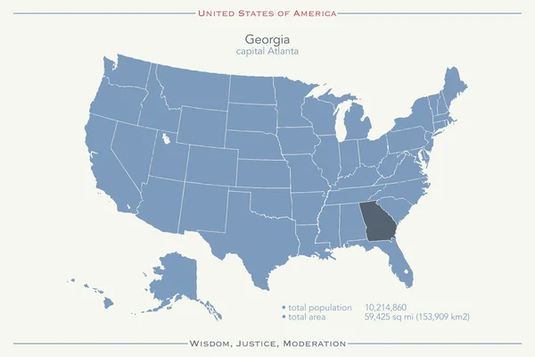
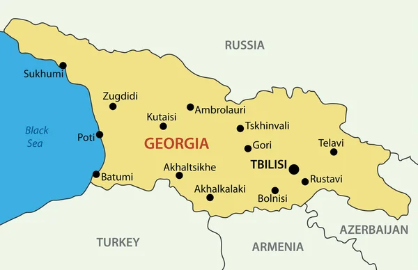
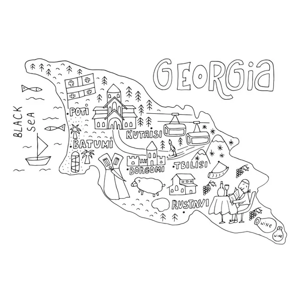
United States Of America Isolated Map And Georgia State Territory. Vector USA Political Map. Geographic Banner Design

Vector, 0.78MB, 6000 × 4000 eps
stock image Landscape of South Georgia

Landscape Of South Georgia

Image, 9.78MB, 4818 × 3207 jpg
stock vector North America Political Map Vintage Colors. Highly detailed map. All elements are separated in editable layers clearly labeled.

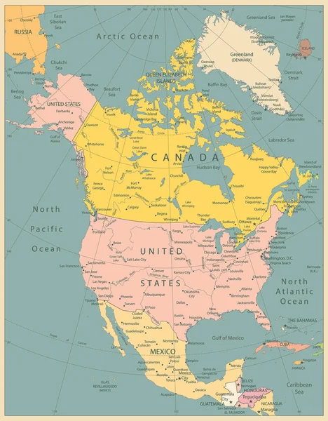
North America Political Map Vintage Colors. Highly Detailed Map. All Elements Are Separated In Editable Layers Clearly Labeled.

Vector, 12.9MB, 3767 × 4826 eps
stock image Sale of agricultural products

Sale Of Agricultural Products

Image, 12.08MB, 5184 × 3456 jpg
stock image Landscape of South Georgia

Landscape Of South Georgia

Image, 25.71MB, 7178 × 4791 jpg
stock image An unidentified sellers

An Unidentified Sellers

Image, 10.55MB, 5184 × 3456 jpg
stock vector Georgia Green Map Vector Design Template

Georgia Green Map Vector Design Template

Vector, 0.45MB, 5000 × 5000 eps
Page 1 >> Next