photo free
Home Images Vectors Videos

Stock image Gulf Of Tomini

stock image Tuna Tomini ferry boat to Togian islands

Tuna Tomini Ferry Boat To Togian Islands

Image, 12.93MB, 5472 × 3648 jpg
stock image Pulau Talatakoh in the Gulf of Tomini - belonging to Indonesia. Described location diagram with yellow shape of the island and sample maps of its surroundings

Pulau Talatakoh In The Gulf Of Tomini - Belonging To Indonesia. Described Location Diagram With Yellow Shape Of The Island And Sample Maps Of Its Surroundings

Image, 2.65MB, 3840 × 2160 jpg
stock image Pulau Batudaka in the Gulf of Tomini, belonging to Indonesia, isolated on a topographic, OSM Humanitarian style map, with distance scale

Pulau Batudaka In The Gulf Of Tomini, Belonging To Indonesia, Isolated On A Topographic, OSM Humanitarian Style Map, With Distance Scale

Image, 0.41MB, 2160 × 2160 jpg
stock image Pulau Togean in the Gulf of Tomini, belonging to Indonesia, isolated on a bilevel elevation map, with distance scale

Pulau Togean In The Gulf Of Tomini, Belonging To Indonesia, Isolated On A Bilevel Elevation Map, With Distance Scale

Image, 0.48MB, 2160 × 2160 jpg
stock image Pulau Talatakoh in the Gulf of Tomini, belonging to Indonesia, isolated on a topographic, OSM Humanitarian style map, with distance scale

Pulau Talatakoh In The Gulf Of Tomini, Belonging To Indonesia, Isolated On A Topographic, OSM Humanitarian Style Map, With Distance Scale

Image, 0.4MB, 2160 × 2160 jpg
stock image Pulau Talatakoh in the Gulf of Tomini, belonging to Indonesia, isolated on a satellite image taken in September 14, 2018, with distance scale

Pulau Talatakoh In The Gulf Of Tomini, Belonging To Indonesia, Isolated On A Satellite Image Taken In September 14, 2018, With Distance Scale

Image, 1.08MB, 2160 × 2160 jpg
stock image Pulau Talatakoh in the Gulf of Tomini on a topographic, OSM Humanitarian style map

Pulau Talatakoh In The Gulf Of Tomini On A Topographic, OSM Humanitarian Style Map

Image, 0.97MB, 2880 × 1620 jpg
stock image Pulau Unauna in the Gulf of Tomini on a colored elevation map

Pulau Unauna In The Gulf Of Tomini On A Colored Elevation Map

Image, 0.98MB, 2880 × 1620 jpg
stock image Celebes Island in the Java Sea - belonging to Indonesia. Described location diagram with yellow shape of the island and sample maps of its surroundings

Celebes Island In The Java Sea - Belonging To Indonesia. Described Location Diagram With Yellow Shape Of The Island And Sample Maps Of Its Surroundings

Image, 3.21MB, 3840 × 2160 jpg
stock image Pulau Waleakodi in the Gulf of Tomini on a topographic, OSM Humanitarian style map

Pulau Waleakodi In The Gulf Of Tomini On A Topographic, OSM Humanitarian Style Map

Image, 0.57MB, 2880 × 1620 jpg
stock image Pulau Togean in the Gulf of Tomini on a colored elevation map

Pulau Togean In The Gulf Of Tomini On A Colored Elevation Map

Image, 1.95MB, 2880 × 1620 jpg
stock image Pulau Togean in the Gulf of Tomini on a satellite image taken in September 14, 2018

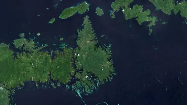
Pulau Togean In The Gulf Of Tomini On A Satellite Image Taken In September 14, 2018

Image, 4.68MB, 2880 × 1620 jpg
stock image Pulau Waleakodi in the Gulf of Tomini - belonging to Indonesia. Described location diagram with yellow shape of the island and sample maps of its surroundings

Pulau Waleakodi In The Gulf Of Tomini - Belonging To Indonesia. Described Location Diagram With Yellow Shape Of The Island And Sample Maps Of Its Surroundings

Image, 2.39MB, 3840 × 2160 jpg
stock image Pulau Waleabahi in the Gulf of Tomini, belonging to Indonesia, isolated on a topographic, OSM Humanitarian style map, with distance scale

Pulau Waleabahi In The Gulf Of Tomini, Belonging To Indonesia, Isolated On A Topographic, OSM Humanitarian Style Map, With Distance Scale

Image, 0.32MB, 2160 × 2160 jpg
stock image Celebes Island in the Java Sea on a topographic, OSM Humanitarian style map

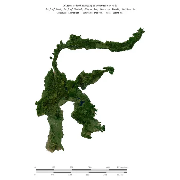
Celebes Island In The Java Sea On A Topographic, OSM Humanitarian Style Map

Image, 2.03MB, 2880 × 1620 jpg
stock image Pulau Unauna in the Gulf of Tomini on a topographic, OSM Humanitarian style map

Pulau Unauna In The Gulf Of Tomini On A Topographic, OSM Humanitarian Style Map

Image, 0.34MB, 2880 × 1620 jpg
stock image Pulau Batudaka in the Gulf of Tomini on a topographic, OSM Humanitarian style map

Pulau Batudaka In The Gulf Of Tomini On A Topographic, OSM Humanitarian Style Map

Image, 0.75MB, 2880 × 1620 jpg
stock image Pulau Waleakodi in the Gulf of Tomini on a satellite image taken in September 4, 2019

Pulau Waleakodi In The Gulf Of Tomini On A Satellite Image Taken In September 4, 2019

Image, 4.06MB, 2880 × 1620 jpg
stock image Pulau Batudaka in the Gulf of Tomini on a colored elevation map

Pulau Batudaka In The Gulf Of Tomini On A Colored Elevation Map

Image, 1.61MB, 2880 × 1620 jpg
stock image Pulau Togean in the Gulf of Tomini, belonging to Indonesia, isolated on a topographic, OSM Humanitarian style map, with distance scale

Pulau Togean In The Gulf Of Tomini, Belonging To Indonesia, Isolated On A Topographic, OSM Humanitarian Style Map, With Distance Scale

Image, 0.5MB, 2160 × 2160 jpg
stock image Pulau Talatakoh in the Gulf of Tomini, belonging to Indonesia, isolated on a bilevel elevation map, with distance scale

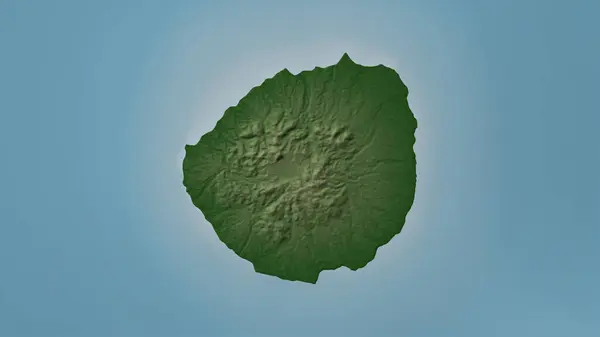
Pulau Talatakoh In The Gulf Of Tomini, Belonging To Indonesia, Isolated On A Bilevel Elevation Map, With Distance Scale

Image, 0.41MB, 2160 × 2160 jpg
stock image Pulau Talatakoh in the Gulf of Tomini on a colored elevation map

Pulau Talatakoh In The Gulf Of Tomini On A Colored Elevation Map

Image, 1.85MB, 2880 × 1620 jpg
stock image Celebes Island in the Java Sea, belonging to Indonesia, isolated on a satellite image taken in September 9, 2018, with distance scale

Celebes Island In The Java Sea, Belonging To Indonesia, Isolated On A Satellite Image Taken In September 9, 2018, With Distance Scale

Image, 1.27MB, 2160 × 2160 jpg
stock image Pulau Waleabahi in the Gulf of Tomini on a colored elevation map

Pulau Waleabahi In The Gulf Of Tomini On A Colored Elevation Map

Image, 1.33MB, 2880 × 1620 jpg
stock image Shape of Pulau Unauna in the Gulf of Tomini, belonging to Indonesia

Shape Of Pulau Unauna In The Gulf Of Tomini, Belonging To Indonesia

Image, 0.21MB, 2160 × 2160 jpg
stock image Pulau Waleabahi in the Gulf of Tomini, belonging to Indonesia, isolated on a satellite image taken in March 17, 2020, with distance scale

Pulau Waleabahi In The Gulf Of Tomini, Belonging To Indonesia, Isolated On A Satellite Image Taken In March 17, 2020, With Distance Scale

Image, 0.84MB, 2160 × 2160 jpg
stock image Celebes Island in the Java Sea on a satellite image taken in January 27, 2016

Celebes Island In The Java Sea On A Satellite Image Taken In January 27, 2016

Image, 4.75MB, 2880 × 1620 jpg
stock image Pulau Batudaka in the Gulf of Tomini, belonging to Indonesia, isolated on a bilevel elevation map, with distance scale

Pulau Batudaka In The Gulf Of Tomini, Belonging To Indonesia, Isolated On A Bilevel Elevation Map, With Distance Scale

Image, 0.51MB, 2160 × 2160 jpg
stock image Pulau Waleabahi in the Gulf of Tomini - belonging to Indonesia. Described location diagram with yellow shape of the island and sample maps of its surroundings

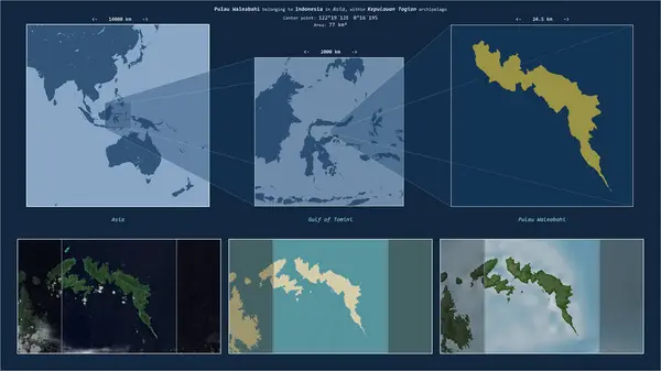
Pulau Waleabahi In The Gulf Of Tomini - Belonging To Indonesia. Described Location Diagram With Yellow Shape Of The Island And Sample Maps Of Its Surroundings

Image, 2.25MB, 3840 × 2160 jpg
stock image Pulau Waleakodi in the Gulf of Tomini, belonging to Indonesia, isolated on a bilevel elevation map, with distance scale

Pulau Waleakodi In The Gulf Of Tomini, Belonging To Indonesia, Isolated On A Bilevel Elevation Map, With Distance Scale

Image, 0.37MB, 2160 × 2160 jpg
stock image Pulau Unauna in the Gulf of Tomini, belonging to Indonesia, isolated on a satellite image taken in August 28, 2019, with distance scale

Pulau Unauna In The Gulf Of Tomini, Belonging To Indonesia, Isolated On A Satellite Image Taken In August 28, 2019, With Distance Scale

Image, 2.04MB, 2160 × 2160 jpg
stock image Pulau Waleabahi in the Gulf of Tomini, belonging to Indonesia, isolated on a bilevel elevation map, with distance scale

Pulau Waleabahi In The Gulf Of Tomini, Belonging To Indonesia, Isolated On A Bilevel Elevation Map, With Distance Scale

Image, 0.33MB, 2160 × 2160 jpg
stock image Pulau Unauna in the Gulf of Tomini, belonging to Indonesia, isolated on a bilevel elevation map, with distance scale

Pulau Unauna In The Gulf Of Tomini, Belonging To Indonesia, Isolated On A Bilevel Elevation Map, With Distance Scale

Image, 0.6MB, 2160 × 2160 jpg
stock image Pulau Waleabahi in the Gulf of Tomini on a topographic, OSM Humanitarian style map

Pulau Waleabahi In The Gulf Of Tomini On A Topographic, OSM Humanitarian Style Map

Image, 0.54MB, 2880 × 1620 jpg
stock image Celebes Island in the Java Sea, belonging to Indonesia, isolated on a bilevel elevation map, with distance scale

Celebes Island In The Java Sea, Belonging To Indonesia, Isolated On A Bilevel Elevation Map, With Distance Scale

Image, 0.65MB, 2160 × 2160 jpg
stock image Pulau Waleabahi in the Gulf of Tomini on a satellite image taken in March 3, 2019

Pulau Waleabahi In The Gulf Of Tomini On A Satellite Image Taken In March 3, 2019

Image, 3.72MB, 2880 × 1620 jpg
stock image Pulau Talatakoh in the Gulf of Tomini on a satellite image taken in October 18, 2023

Pulau Talatakoh In The Gulf Of Tomini On A Satellite Image Taken In October 18, 2023

Image, 4.74MB, 2880 × 1620 jpg
stock image Pulau Unauna in the Gulf of Tomini - belonging to Indonesia. Described location diagram with yellow shape of the island and sample maps of its surroundings

Pulau Unauna In The Gulf Of Tomini - Belonging To Indonesia. Described Location Diagram With Yellow Shape Of The Island And Sample Maps Of Its Surroundings

Image, 2.26MB, 3840 × 2160 jpg
stock image Celebes Island in the Java Sea on a colored elevation map

Celebes Island In The Java Sea On A Colored Elevation Map

Image, 4.64MB, 2880 × 1620 jpg
stock image Pulau Waleakodi in the Gulf of Tomini on a colored elevation map

Pulau Waleakodi In The Gulf Of Tomini On A Colored Elevation Map

Image, 1.37MB, 2880 × 1620 jpg
stock image Pulau Togean in the Gulf of Tomini on a topographic, OSM Humanitarian style map

Pulau Togean In The Gulf Of Tomini On A Topographic, OSM Humanitarian Style Map

Image, 1.02MB, 2880 × 1620 jpg
stock image Pulau Waleakodi in the Gulf of Tomini, belonging to Indonesia, isolated on a topographic, OSM Humanitarian style map, with distance scale

Pulau Waleakodi In The Gulf Of Tomini, Belonging To Indonesia, Isolated On A Topographic, OSM Humanitarian Style Map, With Distance Scale

Image, 0.4MB, 2160 × 2160 jpg
stock image Celebes Island in the Java Sea, belonging to Indonesia, isolated on a topographic, OSM Humanitarian style map, with distance scale

Celebes Island In The Java Sea, Belonging To Indonesia, Isolated On A Topographic, OSM Humanitarian Style Map, With Distance Scale

Image, 0.96MB, 2160 × 2160 jpg
stock image Pulau Unauna in the Gulf of Tomini on a satellite image taken in December 26, 2018

Pulau Unauna In The Gulf Of Tomini On A Satellite Image Taken In December 26, 2018

Image, 4.99MB, 2880 × 1620 jpg
stock image Pulau Togean in the Gulf of Tomini, belonging to Indonesia, isolated on a satellite image taken in February 28, 2024, with distance scale

Pulau Togean In The Gulf Of Tomini, Belonging To Indonesia, Isolated On A Satellite Image Taken In February 28, 2024, With Distance Scale

Image, 1.28MB, 2160 × 2160 jpg
stock image Pulau Unauna in the Gulf of Tomini, belonging to Indonesia, isolated on a topographic, OSM Humanitarian style map, with distance scale

Pulau Unauna In The Gulf Of Tomini, Belonging To Indonesia, Isolated On A Topographic, OSM Humanitarian Style Map, With Distance Scale

Image, 0.53MB, 2160 × 2160 jpg
stock image Pulau Batudaka in the Gulf of Tomini, belonging to Indonesia, isolated on a satellite image taken in August 20, 2018, with distance scale

Pulau Batudaka In The Gulf Of Tomini, Belonging To Indonesia, Isolated On A Satellite Image Taken In August 20, 2018, With Distance Scale

Image, 1.14MB, 2160 × 2160 jpg
stock image Pulau Batudaka in the Gulf of Tomini - belonging to Indonesia. Described location diagram with yellow shape of the island and sample maps of its surroundings

Pulau Batudaka In The Gulf Of Tomini - Belonging To Indonesia. Described Location Diagram With Yellow Shape Of The Island And Sample Maps Of Its Surroundings

Image, 2.28MB, 3840 × 2160 jpg
stock image Pulau Togean in the Gulf of Tomini - belonging to Indonesia. Described location diagram with yellow shape of the island and sample maps of its surroundings

Pulau Togean In The Gulf Of Tomini - Belonging To Indonesia. Described Location Diagram With Yellow Shape Of The Island And Sample Maps Of Its Surroundings

Image, 2.66MB, 3840 × 2160 jpg
stock image Pulau Batudaka in the Gulf of Tomini on a satellite image taken in July 19, 2018

Pulau Batudaka In The Gulf Of Tomini On A Satellite Image Taken In July 19, 2018

Image, 4.31MB, 2880 × 1620 jpg
Page 1 >> Next