photo free
Home Images Vectors Videos

Stock image Kagoshima Map

stock vector Kagoshima Map frame icon

Kagoshima Map Frame Icon

Vector, 0.27MB, 4521 × 4521 ai
stock vector Map of Japan with borders as scrible

Map Of Japan With Borders As Scrible

Vector, 0.83MB, 3412 × 4758 ai
stock vector Japan prefectures (japanese names gives in parentheses) vector map colored be regions with neighbouring countries and territories

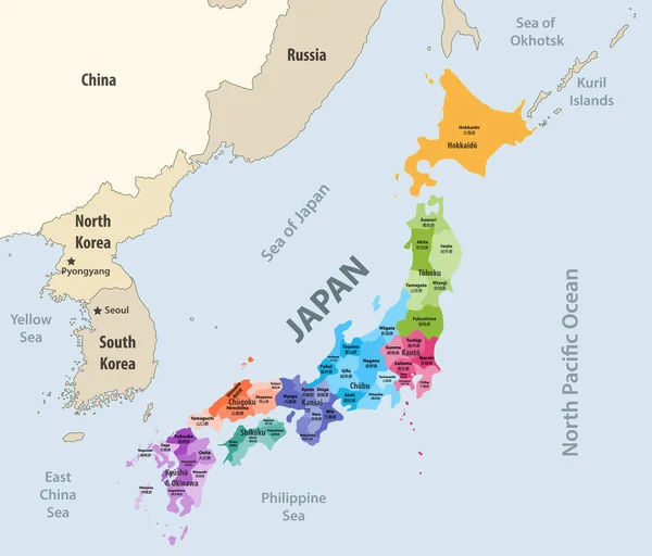
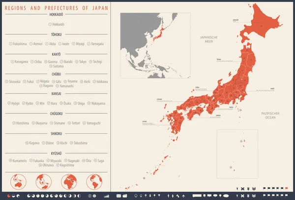
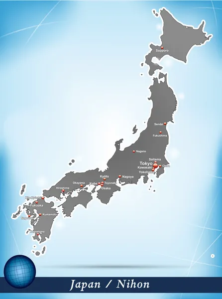
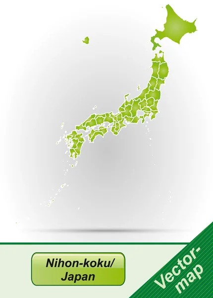
Japan Prefectures (japanese Names Gives In Parentheses) Vector Map Colored Be Regions With Neighbouring Countries And Territories

Vector, 6.87MB, 8333 × 7112 eps
stock vector Japan map

Japan Map

Vector, 3.02MB, 4520 × 4520 ai
stock vector vector illustration of Japanese flag and prefectures map colored by regions. Largest city skylines, navigation, location, and travel icons

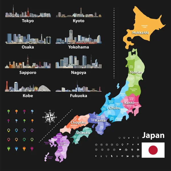
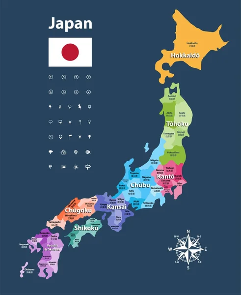
Vector Illustration Of Japanese Flag And Prefectures Map Colored By Regions. Largest City Skylines, Navigation, Location, And Travel Icons

Vector, 12.9MB, 7293 × 7292 eps
stock vector Map Japan prefectures green

Map Japan Prefectures Green

Vector, 0.78MB, 4520 × 4533 ai
stock vector Detailed vector map Regions and prefectures of Japan

Detailed Vector Map Regions And Prefectures Of Japan

Vector, 4.89MB, 7677 × 5235 eps
stock image Japan on the map background

Japan On The Map Background

Image, 12.72MB, 6000 × 4000 jpg
stock vector Japan prefectures vector map colored be regions. Japanese names gives in parentheses. Flag of Japan

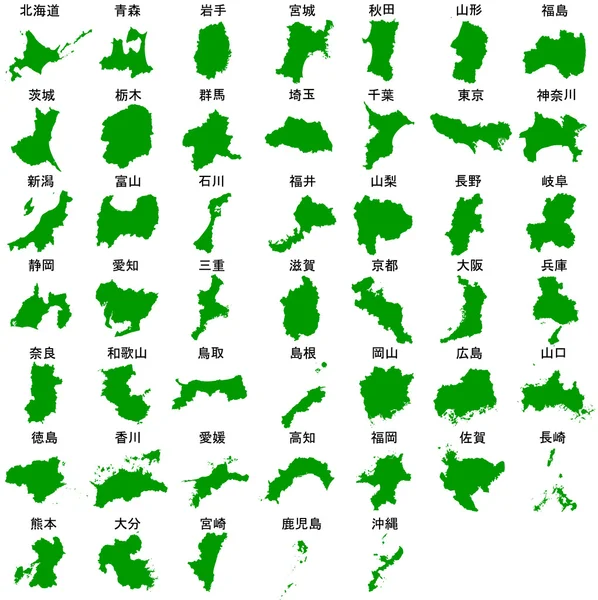
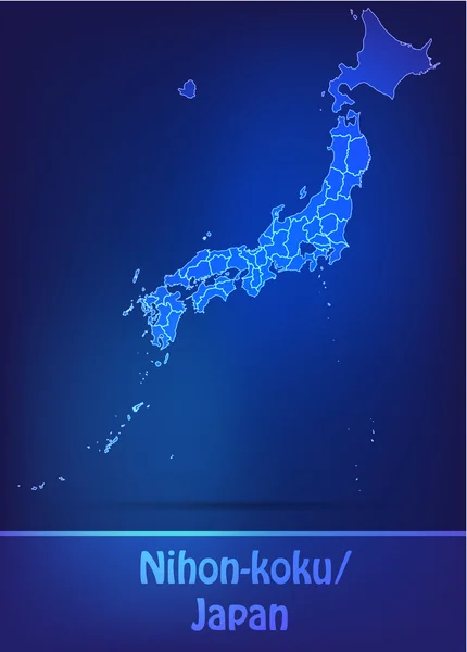
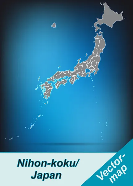
Japan Prefectures Vector Map Colored Be Regions. Japanese Names Gives In Parentheses. Flag Of Japan

Vector, 6.15MB, 5975 × 7292 eps
stock vector Kyushu map green icon

Kyushu Map Green Icon

Vector, 0.3MB, 4520 × 4520 ai
stock vector Kyushu map.

Kyushu Map.

Vector, 2.54MB, 8268 × 7992 eps
stock image kagoshima flag of Troms prefecture on map with administrative divisions and borders of japan

Kagoshima Flag Of Troms Prefecture On Map With Administrative Divisions And Borders Of Japan

Image, 0.73MB, 4576 × 4531 jpg
stock vector Map of Japan

Map Of Japan

Vector, 0.81MB, 3454 × 4637 ai
stock image Kagoshima, prefecture of Japan. Elevation map colored in sepia tones with lakes and rivers. Locations and names of major cities of the region. Corner auxiliary location maps

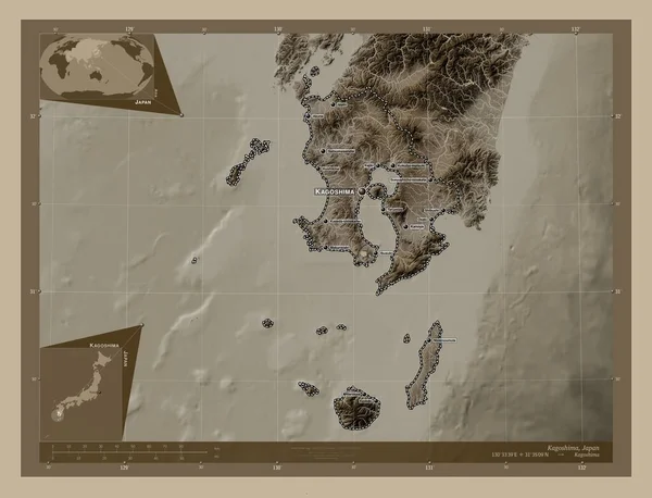
Kagoshima, Prefecture Of Japan. Elevation Map Colored In Sepia Tones With Lakes And Rivers. Locations And Names Of Major Cities Of The Region. Corner Auxiliary Location Maps

Image, 5.49MB, 4930 × 3770 jpg
stock vector Map of Japan

Map Of Japan

Vector, 0.49MB, 3412 × 4758 ai
stock vector fukuoka prefecture icon vector sign and symbol isolated on white

Fukuoka Prefecture Icon Vector Sign And Symbol Isolated On White

Vector, 2.69MB, 6945 × 6945 eps
stock vector Miyagi map, Japan, Asia. Filled and outline map designs. Vector illustration

Miyagi Map, Japan, Asia. Filled And Outline Map Designs. Vector Illustration

Vector, 0.36MB, 6001 × 3001 eps
stock vector Map of Japan

Map Of Japan

Vector, 0.29MB, 3412 × 4758 ai
stock image Nakanoshima, Kagoshima Island in the Eastern China Sea - belonging to Japan. Described location diagram with yellow shape of the island and sample maps of its surroundings

Nakanoshima, Kagoshima Island In The Eastern China Sea - Belonging To Japan. Described Location Diagram With Yellow Shape Of The Island And Sample Maps Of Its Surroundings

Image, 2.07MB, 3840 × 2160 jpg
stock vector Kagoshima Japan Map Green Icon

Kagoshima Japan Map Green Icon

Vector, 3.66MB, 3544 × 5246 eps
stock image Nagashima, Kagoshima Island in the Eastern China Sea - belonging to Japan. Described location diagram with yellow shape of the island and sample maps of its surroundings

Nagashima, Kagoshima Island In The Eastern China Sea - Belonging To Japan. Described Location Diagram With Yellow Shape Of The Island And Sample Maps Of Its Surroundings

Image, 2.8MB, 3840 × 2160 jpg
stock image Nakanoshima, Kagoshima Island in the Eastern China Sea on a topographic, OSM Humanitarian style map

Nakanoshima, Kagoshima Island In The Eastern China Sea On A Topographic, OSM Humanitarian Style Map

Image, 0.47MB, 2880 × 1620 jpg
stock image Nagashima, Kagoshima Island in the Eastern China Sea on a colored elevation map

Nagashima, Kagoshima Island In The Eastern China Sea On A Colored Elevation Map

Image, 1.5MB, 2880 × 1620 jpg
stock vector Symbol Map of the Prefecture Kagoshima (Japan) showing the state/province with a pattern of black circles

Symbol Map Of The Prefecture Kagoshima (Japan) Showing The State/province With A Pattern Of Black Circles

Vector, 0.8MB, 3533 × 6000 eps
stock vector Symbol Map of the Prefecture Kagoshima (Japan) showing the contour of the state/province buffered inside in rainbow colors

Symbol Map Of The Prefecture Kagoshima (Japan) Showing The Contour Of The State/province Buffered Inside In Rainbow Colors

Vector, 0.79MB, 3533 × 6000 eps
stock image Nagashima, Kagoshima Island in the Eastern China Sea, belonging to Japan, isolated on a bilevel elevation map, with distance scale

Nagashima, Kagoshima Island In The Eastern China Sea, Belonging To Japan, Isolated On A Bilevel Elevation Map, With Distance Scale

Image, 0.4MB, 2160 × 2160 jpg
stock vector Map of Japan with borders

Map Of Japan With Borders

Vector, 0.67MB, 3868 × 4214 ai
stock vector Symbol Map of the Prefecture Kagoshima (Japan). Abstract map showing the state/province with a pattern of black and white squares like a chessboard

Symbol Map Of The Prefecture Kagoshima (Japan). Abstract Map Showing The State/province With A Pattern Of Black And White Squares Like A Chessboard

Vector, 0.62MB, 3533 × 6000 eps
stock vector nabe icon. Thin, Light Regular And Bold style design isolated on white background

Nabe Icon. Thin, Light Regular And Bold Style Design Isolated On White Background

Vector, 0.24MB, 8000 × 2000 eps
stock vector Map of Japan

Map Of Japan

Vector, 0.22MB, 3399 × 4751 ai
stock image Nakanoshima, Kagoshima Island in the Eastern China Sea, belonging to Japan, isolated on a satellite image taken in November 17, 2021, with distance scale

Nakanoshima, Kagoshima Island In The Eastern China Sea, Belonging To Japan, Isolated On A Satellite Image Taken In November 17, 2021, With Distance Scale

Image, 2.03MB, 2160 × 2160 jpg
stock vector Kyushu island and northern part of the Kyushu region in Japan, political map with prefectures. One of the four major islands of Japan, southwest of Honshu and Shikoku, separated by Seto Inland Sea.

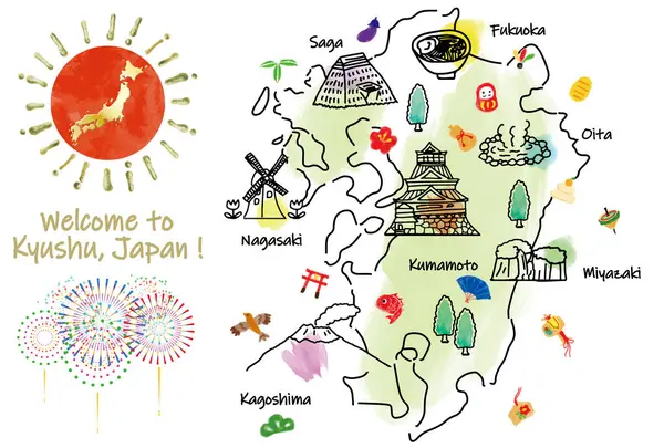
Kyushu Island And Northern Part Of The Kyushu Region In Japan, Political Map With Prefectures. One Of The Four Major Islands Of Japan, Southwest Of Honshu And Shikoku, Separated By Seto Inland Sea.

Vector, 8.66MB, 6000 × 6857 eps
stock vector Symbol Map of the Prefecture Kagoshima (Japan) showing the state/province with a pattern of randomly distributed colorful squares of different sizes

Symbol Map Of The Prefecture Kagoshima (Japan) Showing The State/province With A Pattern Of Randomly Distributed Colorful Squares Of Different Sizes

Vector, 0.64MB, 3533 × 6000 eps
stock image Nakanoshima, Kagoshima Island in the Eastern China Sea, belonging to Japan, isolated on a bilevel elevation map, with distance scale

Nakanoshima, Kagoshima Island In The Eastern China Sea, Belonging To Japan, Isolated On A Bilevel Elevation Map, With Distance Scale

Image, 0.38MB, 2160 × 2160 jpg
stock image Nagashima, Kagoshima Island in the Eastern China Sea on a satellite image taken in May 31, 2021

Nagashima, Kagoshima Island In The Eastern China Sea On A Satellite Image Taken In May 31, 2021

Image, 5.12MB, 2880 × 1620 jpg
stock image Nakanoshima, Kagoshima Island in the Eastern China Sea on a colored elevation map

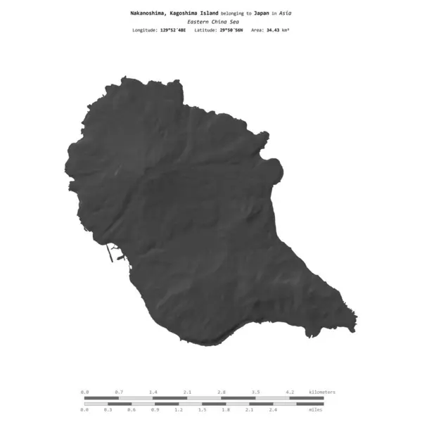
Nakanoshima, Kagoshima Island In The Eastern China Sea On A Colored Elevation Map

Image, 0.82MB, 2880 × 1620 jpg
stock image KYUSHU, Japan. Hand drawn map and icons

KYUSHU, Japan. Hand Drawn Map And Icons

Image, 3.62MB, 5000 × 3378 jpg
stock image Nakanoshima, Kagoshima Island in the Eastern China Sea on a satellite image taken in May 16, 2023

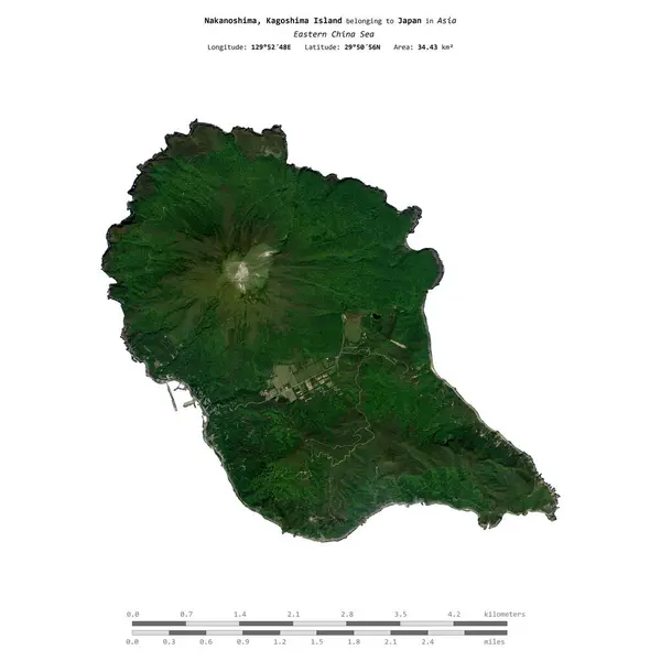
Nakanoshima, Kagoshima Island In The Eastern China Sea On A Satellite Image Taken In May 16, 2023

Image, 4.51MB, 2880 × 1620 jpg
stock image Nagashima, Kagoshima Island in the Eastern China Sea, belonging to Japan, isolated on a topographic, OSM Humanitarian style map, with distance scale

Nagashima, Kagoshima Island In The Eastern China Sea, Belonging To Japan, Isolated On A Topographic, OSM Humanitarian Style Map, With Distance Scale

Image, 1.3MB, 2160 × 2160 jpg
stock image Nagashima, Kagoshima Island in the Eastern China Sea, belonging to Japan, isolated on a satellite image taken in November 2, 2023, with distance scale

Nagashima, Kagoshima Island In The Eastern China Sea, Belonging To Japan, Isolated On A Satellite Image Taken In November 2, 2023, With Distance Scale

Image, 1.65MB, 2160 × 2160 jpg
stock image Nagashima, Kagoshima Island in the Eastern China Sea on a topographic, OSM Humanitarian style map

Nagashima, Kagoshima Island In The Eastern China Sea On A Topographic, OSM Humanitarian Style Map

Image, 2.53MB, 2880 × 1620 jpg
stock image Nakanoshima, Kagoshima Island in the Eastern China Sea, belonging to Japan, isolated on a topographic, OSM Humanitarian style map, with distance scale

Nakanoshima, Kagoshima Island In The Eastern China Sea, Belonging To Japan, Isolated On A Topographic, OSM Humanitarian Style Map, With Distance Scale

Image, 0.65MB, 2160 × 2160 jpg
Page 1 >> Next