photo free
Home Images Vectors Videos

Stock image Kennebec

stock image Fort Popham, a Civil War-era coastal defense fortification at the mouth of the Kennebec River, rear wall of the Fort, Phippsburg, ME, USA - July 25, 2020

Fort Popham, A Civil War-era Coastal Defense Fortification At The Mouth Of The Kennebec River, Rear Wall Of The Fort, Phippsburg, ME, USA - July 25, 2020

Image, 6.17MB, 5456 × 3632 jpg
stock image Augusta, Maine, USA skyline on the Kennebec River at twilight.

Augusta, Maine, USA Skyline On The Kennebec River At Twilight.

Image, 24.73MB, 7360 × 4912 jpg
stock image Memorial Bridge across the Kennebec River, built in 1949, view from the east bank of the river, Augusta, ME, USA - July 26, 2020

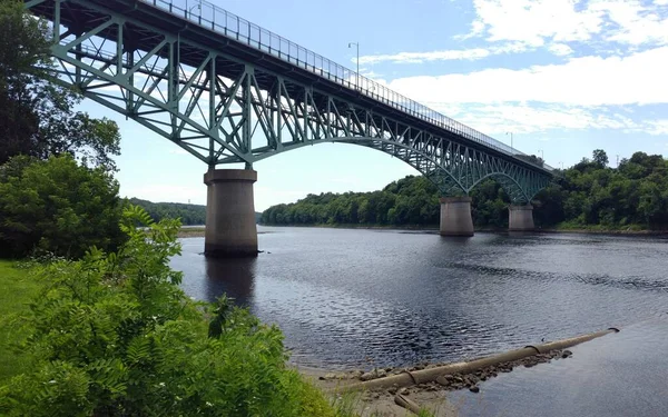
Memorial Bridge Across The Kennebec River, Built In 1949, View From The East Bank Of The River, Augusta, ME, USA - July 26, 2020

Image, 9.08MB, 5353 × 3348 jpg
stock vector Maine, ME, political map with capital Augusta. Northernmost state in the United States of America, and located in the New England region. The Pine Tree State. Vacationland. Illustration. Vector.

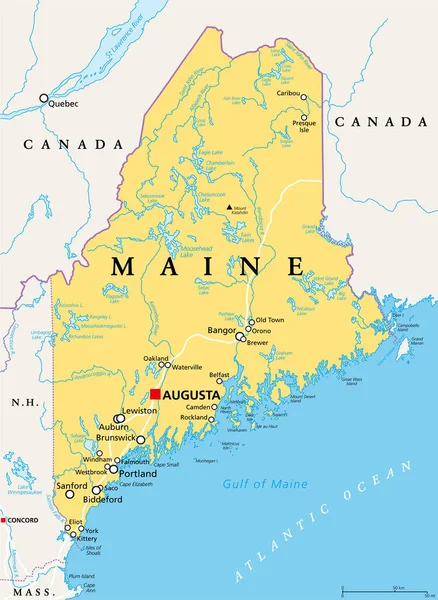
Maine, ME, Political Map With Capital Augusta. Northernmost State In The United States Of America, And Located In The New England Region. The Pine Tree State. Vacationland. Illustration. Vector.

Vector, 4.8MB, 6000 × 8208 eps
stock image Augusta, Maine, USA

Augusta, Maine, USA

Image, 15.61MB, 6000 × 4004 jpg
stock image Wooden Walkway Doubling Point Lighthouse in Maine

Wooden Walkway Doubling Point Lighthouse In Maine

Image, 9.44MB, 3872 × 2592 jpg
stock image Augusta, Maine, USA skyline on the Kennebec River at twilight.

Augusta, Maine, USA Skyline On The Kennebec River At Twilight.

Image, 17.33MB, 7360 × 4140 jpg
stock image Doubling Point Lighthouse

Doubling Point Lighthouse

Image, 2.27MB, 3008 × 2000 jpg
stock image Doubling Point Lighthouse in Arrowsic, Maine USA

Doubling Point Lighthouse In Arrowsic, Maine USA

Image, 4.89MB, 4032 × 3024 jpg
stock image Augusta skyline panorama on a sunny afternoon

Augusta Skyline Panorama On A Sunny Afternoon

Image, 25.55MB, 11636 × 3674 jpg
stock image Augusta, Maine River

Augusta, Maine River

Image, 13.26MB, 6000 × 4004 jpg
stock image The Doubling Point Lighhouse, Kennebec River, Arrowsic, Maine

The Doubling Point Lighhouse, Kennebec River, Arrowsic, Maine

Image, 13.15MB, 4480 × 6720 jpg
stock image Augusta, Maine, USA skyline on the Kennebec River at twilight.

Augusta, Maine, USA Skyline On The Kennebec River At Twilight.

Image, 20.21MB, 7360 × 4912 jpg
stock image Old landmark Fort Western, former British colonial outpost at the head of navigation on the Kennebec River, built in 1754 during the French and Indian War, Augusta, ME, USA - July 26, 2020

Old Landmark Fort Western, Former British Colonial Outpost At The Head Of Navigation On The Kennebec River, Built In 1754 During The French And Indian War, Augusta, ME, USA - July 26, 2020

Image, 15.17MB, 5089 × 2160 jpg
stock image Augusta Maine Skyline

Augusta Maine Skyline

Image, 20.72MB, 6600 × 4405 jpg
stock vector U.S. states - map of Maine. Hand made. Rivers and lakes are shown. Please look at my other images of cartographic series - they are all very detailed and carefully drawn by hand WITH RIVERS AND LAKES.

U.S. States - Map Of Maine. Hand Made. Rivers And Lakes Are Shown. Please Look At My Other Images Of Cartographic Series - They Are All Very Detailed And Carefully Drawn By Hand WITH RIVERS AND LAKES.

Vector, 2.8MB, 6060 × 8080 eps
stock image Kennebec white potatos

Kennebec White Potatos

Image, 3.99MB, 3008 × 1992 jpg
stock image Hendricks Head Lighthouse

Hendricks Head Lighthouse

Image, 1.95MB, 3008 × 2000 jpg
stock image The Doubling Point Lighhouse, Kennebec River, Arrowsic, Maine

The Doubling Point Lighhouse, Kennebec River, Arrowsic, Maine

Image, 15.34MB, 6720 × 4480 jpg
stock image The Doubling Point Lighhouse, Kennebec River, Arrowsic, Maine

The Doubling Point Lighhouse, Kennebec River, Arrowsic, Maine

Image, 30.76MB, 6720 × 4480 jpg
stock image Augusta, Maine, USA Skyline

Augusta, Maine, USA Skyline

Image, 16.56MB, 6600 × 4405 jpg
stock image Augusta, Maine, USA

Augusta, Maine, USA

Image, 15.7MB, 6000 × 4004 jpg
stock image Country house at the Gilbert Head point of the Long Island in the Kennebec River estuary, view across the water from the Fort Popham, ME, USA - July 25, 2020

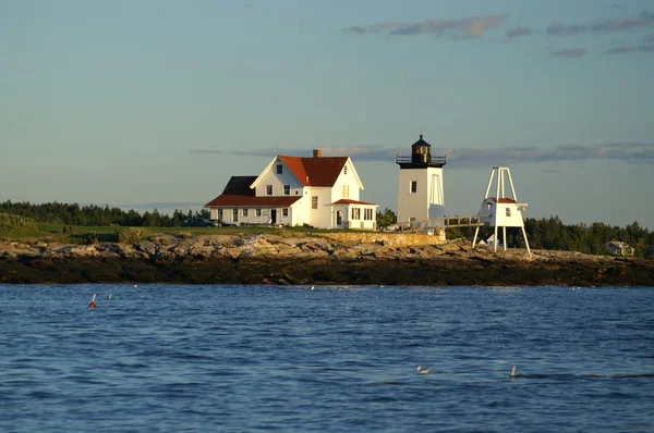
Country House At The Gilbert Head Point Of The Long Island In The Kennebec River Estuary, View Across The Water From The Fort Popham, ME, USA - July 25, 2020

Image, 5.55MB, 5455 × 3078 jpg
stock image Old landmark Fort Western, former British colonial outpost at the head of navigation on the Kennebec River, built in 1754 during the French and Indian War, Augusta, ME, USA - July 26, 2020

Old Landmark Fort Western, Former British Colonial Outpost At The Head Of Navigation On The Kennebec River, Built In 1754 During The French And Indian War, Augusta, ME, USA - July 26, 2020

Image, 9.7MB, 5184 × 3243 jpg
stock image Augusta, Maine, USA skyline on the Kennebec River in the morning.

Augusta, Maine, USA Skyline On The Kennebec River In The Morning.

Image, 30.72MB, 7360 × 4912 jpg
stock image The Doubling Point Lighhouse, Kennebec River, Arrowsic, Maine

The Doubling Point Lighhouse, Kennebec River, Arrowsic, Maine

Image, 5.35MB, 6720 × 4480 jpg
stock image Augusta, Maine, USA Skyline

Augusta, Maine, USA Skyline

Image, 17.64MB, 6600 × 4405 jpg
stock image Augusta, Maine, USA Skyline

Augusta, Maine, USA Skyline

Image, 19.17MB, 6000 × 4004 jpg
stock image Augusta skyline on a sunny afternoon

Augusta Skyline On A Sunny Afternoon

Image, 10.77MB, 5744 × 3829 jpg
stock image The Doubling Point Lighhouse, Kennebec River, Arrowsic, Maine

The Doubling Point Lighhouse, Kennebec River, Arrowsic, Maine

Image, 11.99MB, 6720 × 4480 jpg
Page 1 >> Next