photo free
Home Images Vectors Videos

Stock image Kenton County

stock image A rendered green 3D highway sign

A Rendered Green 3D Highway Sign

Image, 0.72MB, 5200 × 3000 jpg
stock image Jumbo Falls in Autumn

Jumbo Falls In Autumn

Image, 8.03MB, 3377 × 2250 jpg
stock image October Reflections on Lake Plumbago

October Reflections On Lake Plumbago

Image, 12.06MB, 4353 × 2900 jpg
stock vector Kentucky, U.S. state subdivided into 120 counties, gray political map with borders and county names. Commonwealth of Kentucky, a state in the Southeastern Region of USA, nicknamed The Bluegrass State.

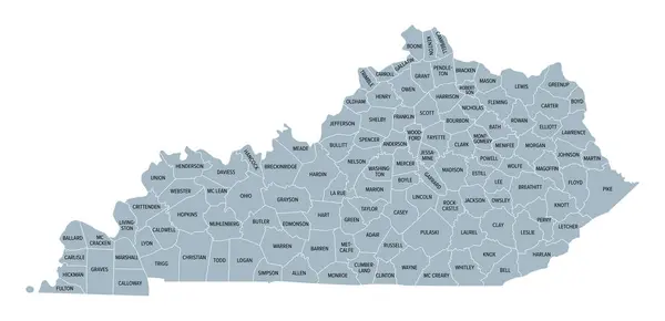
Kentucky, U.S. State Subdivided Into 120 Counties, Gray Political Map With Borders And County Names. Commonwealth Of Kentucky, A State In The Southeastern Region Of USA, Nicknamed The Bluegrass State.

Vector, 2.14MB, 9000 × 4352 eps
stock vector Kentucky, U.S. state subdivided into 120 counties, political map with borders and county names. Commonwealth of Kentucky, a state in the Southeastern Region of the USA, nicknamed The Bluegrass State.

Kentucky, U.S. State Subdivided Into 120 Counties, Political Map With Borders And County Names. Commonwealth Of Kentucky, A State In The Southeastern Region Of The USA, Nicknamed The Bluegrass State.

Vector, 2.56MB, 9000 × 4635 eps
stock vector Kentucky, U.S. state, multi colored political map with borders, county names and Capital Frankfort. State in the Southeastern Region of the United States, subdivided into 120 counties. Bluegrass State

Kentucky, U.S. State, Multi Colored Political Map With Borders, County Names And Capital Frankfort. State In The Southeastern Region Of The United States, Subdivided Into 120 Counties. Bluegrass State

Vector, 2.16MB, 9000 × 4352 eps
Page 1 >> Next