
Stock image Land Marker
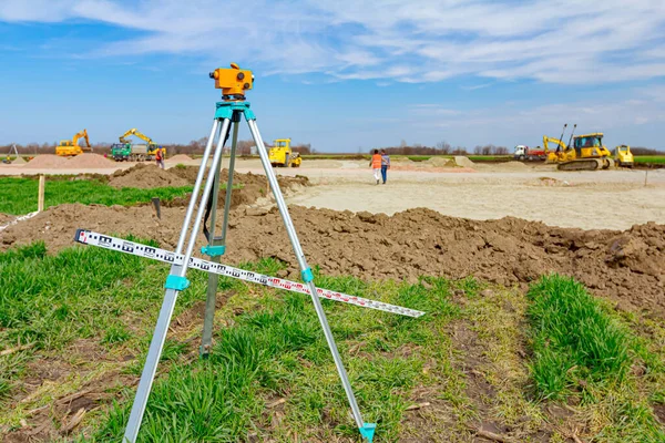
Surveyor Instrument And Leveling Lath Are Used For Measuring Level On Construction Site. Surveyors Ensure Precise Measurements Before Undertaking Large Construction Projects.
Image, 14.09MB, 5184 × 3456 jpg


Young Confident Pioneer Conquering New Land, Somewhere Far Away From Civilization
Vector, 4.07MB, 3542 × 5208 eps
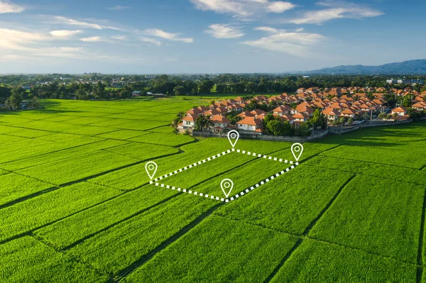
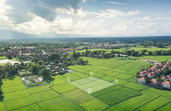
Land Plot In Aerial View. Identify Registration Symbol Of Vacant Area For Map. That Property, Real Estate For Business Of Home, House Or Residential I.e. Construction, Development, Sale, Rent And Buy.
Image, 16.35MB, 5464 × 3640 jpg
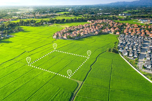
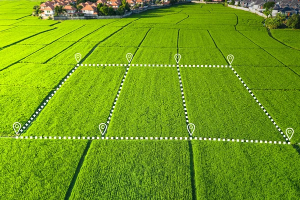
Land Plot In Aerial View. Identify Registration Symbol Of Vacant Area For Map. That Property, Real Estate For Business Of Home, House Or Residential I.e. Construction, Development, Sale, Rent And Buy.
Image, 20.01MB, 5464 × 3640 jpg

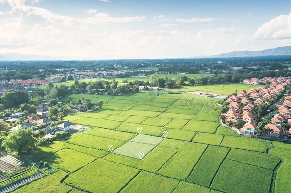
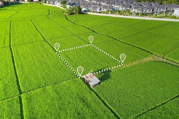
Land Plot In Aerial View. Identify Registration Symbol Of Vacant Area For Map. That Property, Real Estate For Business Of Home, House Or Residential I.e. Construction, Development, Sale, Rent, Buy.
Image, 20.73MB, 5464 × 3640 jpg

Land Plot In Aerial View. Identify Registration Symbol Of Vacant Area For Map. That Property, Real Estate For Business Of Home, House Or Residential I.e. Construction, Development, Sale, Rent, Buy, Purchase Or Investment.
Image, 17.1MB, 5464 × 3640 jpg
Land Plot In Aerial View. Identify Registration Symbol Of Vacant Area For Map. That Property, Real Estate For Business Of Home, House Or Residential I.e. Construction, Development, Sale, Rent, Buy.
Image, 12.96MB, 5464 × 3640 jpg

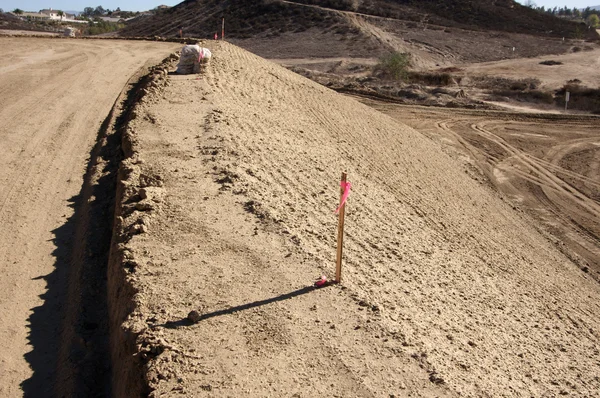
The Dug-out Land Began Construction Of The Road Against The Blue Sky With Clouds
Image, 7.96MB, 4863 × 3237 jpg
Land Plot In Aerial View. Identify Registration Symbol Of Vacant Area For Map. That Property, Real Estate For Business Of Home, House Or Residential I.e. Construction, Development, Sale, Rent, Buy.
Image, 11.67MB, 5464 × 3562 jpg


The Dug-out Land Began Construction Of The Road Against The Blue Sky With Clouds
Image, 9.02MB, 4928 × 3280 jpg
Land Plot In Aerial View. Identify Registration Symbol Of Vacant Area For Map. That Property, Real Estate For Business Of Home, House Or Residential I.e. Construction, Development, Sale, Rent And Buy.
Image, 27.16MB, 5464 × 3640 jpg
Land Plot In Aerial View. Identify Registration Symbol Of Vacant Area For Map. That Property, Real Estate For Business Of Home, House Or Residential I.e. Construction, Development, Sale, Rent And Buy.
Image, 23.32MB, 5464 × 3640 jpg
Vector Icon. Map Of The World. Point On The . Pin And The Distance, GPS Navigator . Flat Style
Vector, 5.78MB, 5001 × 5000 eps
Map Location Icon Like Geotag Logo. Concept Of Tourism Mobile App Or Get Directions And Right District. Abstract Flat Checkpoint Logotype Modern Graphic Brand Ui Design Isolated On White Background
Vector, 0.63MB, 5000 × 5000 eps

Land Plot In Aerial View. Identify Registration Symbol Of Vacant Area For Map. That Property, Real Estate For Business Of Home, House Or Residential I.e. Construction, Development, Sale, Rent And Buy.
Image, 16.29MB, 5464 × 3640 jpg

Land For Sale And Investment In Aerial View. Include Green Field, Agriculture Farm, Residential House Building, Village. That Real Estate Or Property. Plot Of Land Lot For Subdivision Or Development.
Image, 16.91MB, 5464 × 3640 jpg

Land Plot In Aerial View. Identify Registration Symbol Of Vacant Area For Map. That Property, Real Estate For Business Of Home, House Or Residential I.e. Construction, Development, Sale, Rent, Buy, Purchase Or Investment.
Image, 14.84MB, 5464 × 3640 jpg


Strengthening The Roadside With Concrete Slabs With Grass And Trees On A Blue Sky With Clouds
Image, 13.59MB, 4928 × 3280 jpg
Vector Icon. Map Of The World. Point On The . Pin And The Distance, GPS Navigator . Flat Style
Vector, 5.32MB, 4998 × 4999 eps
Perspective City Map Navigation With Pin Pointers. Urban Downtown Streets Gps Navigator With Red Location Markers Vector Illustration
Vector, 1.86MB, 6268 × 3989 eps

Road Path Like Thin Map Geolocation Icon, Symbol Of Show Or Check Transport Route Or Find The Right Place Concept Outline Simple Abstract Mapping Logotype Brand Graphic Ui Design On White
Vector, 0.58MB, 6944 × 6944 eps

A Map With A Red Marker. Location Indicator. Pointer Of The Destination. Fully Editable Vector Image.
Vector, 3.11MB, 5000 × 5000 eps


Landscape View Of A Red Blueberry Field Captured During The Winter Months On A Farm.
Image, 22.2MB, 5500 × 3667 jpg

Construction Worker Is Holding Leveling Rod To Help Surveyor, Geodesist To Measure Position, Depth.
Image, 11.41MB, 5184 × 3456 jpg


3d Map Navigation Pointers Vector 3d Illustration. Wireframe Landscape Business Concept. 3d Vector Background Technology Background.
Vector, 8.3MB, 4727 × 3000 eps


Page 1 >> Next