
Stock image Malacca Strait page 2
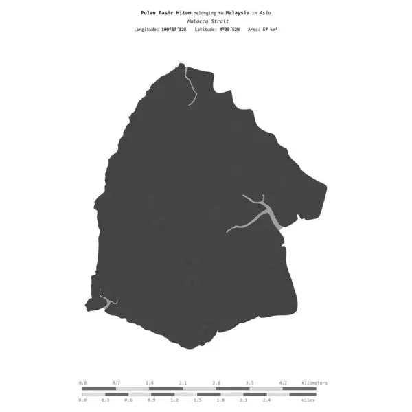
Pulau Pasir Hitam In The Malacca Strait, Belonging To Malaysia, Isolated On A Bilevel Elevation Map, With Distance Scale
Image, 0.31MB, 2160 × 2160 jpg

Ko Rawi Island In The Malacca Strait, Belonging To Thailand, Isolated On A Bilevel Elevation Map, With Distance Scale
Image, 0.29MB, 2160 × 2160 jpg

Pulau Batu Kawan In The Malacca Strait On A Satellite Image Taken In December 4, 2023
Image, 6.42MB, 2880 × 1620 jpg

Stunning Views Of The City And Malacca Strait At Dusk,from The Rooftop Of George Town's Tallest Building And Prominent Landmark,with Dramatic Clouds Over Mainland Malaysia In The Background.
Image, 20.43MB, 6700 × 4472 jpg

Stunning Views Of The City And Malacca Strait,from The Rooftop Of George Town's Tallest Building And Prominent Landmark,with Dramatic Clouds Over Mainland Malaysia In The Background,close To Sunset.
Image, 19.12MB, 6700 × 5632 jpg

Penang Island,Malaysia-April 25 2023: Along The Old Clan Jetty Boardwalks,near Sunset,visitors Stand, Sit And Take Photos By The Waterside,with Motor Boats In The Waters Of The Malacca Strait.
Image, 14.27MB, 6700 × 4275 jpg

Penang Island,Malaysia-April 26 2023: At Sunset On George Town's Tallest Building,called 'The Top',with Bar,restaurant And Skywalk,at 252 Metres High On Floor Level 68,a Popular Tourist Destination.
Image, 15.32MB, 6700 × 4270 jpg

The Beautiful Clan Piers Of Penang And Floating Village,wooden Structures Built On Stilts,in The Calm Waters Of The Mallaca Strait,where The Immigrant Chinese Clans Live,a UNESCO World Heritage Site.
Image, 15.92MB, 6700 × 4825 jpg


Pulau Dayang Bunting In The Malacca Strait, Belonging To Malaysia, Isolated On A Bilevel Elevation Map, With Distance Scale
Image, 0.31MB, 2160 × 2160 jpg

Phuket Island In The Malacca Strait, Belonging To Thailand, Isolated On A Topographic, OSM Humanitarian Style Map, With Distance Scale
Image, 0.86MB, 2160 × 2160 jpg
Pulau Langkawi In The Malacca Strait On A Satellite Image Taken In March 12, 2020
Image, 4.39MB, 2880 × 1620 jpg

Pulau Trong In The Malacca Strait - Belonging To Malaysia. Described Location Diagram With Yellow Shape Of The Island And Sample Maps Of Its Surroundings
Image, 2.65MB, 3840 × 2160 jpg

Pulau Pandang In The Malacca Strait, Belonging To Indonesia, Isolated On A Satellite Image Taken In January 24, 2020, With Distance Scale
Image, 1.24MB, 2160 × 2160 jpg

Ko Libong Island In The Malacca Strait On A Topographic, OSM Humanitarian Style Map
Image, 0.45MB, 2880 × 1620 jpg

Ko Lanta Yai Island In The Malacca Strait, Belonging To Thailand, Isolated On A Topographic, OSM Humanitarian Style Map, With Distance Scale
Image, 0.49MB, 2160 × 2160 jpg
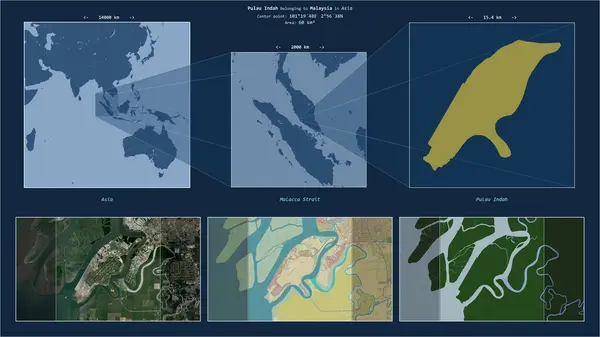
Pulau Indah In The Malacca Strait - Belonging To Malaysia. Described Location Diagram With Yellow Shape Of The Island And Sample Maps Of Its Surroundings
Image, 3.12MB, 3840 × 2160 jpg


Ko Libong Island In The Malacca Strait On A Satellite Image Taken In April 11, 2023
Image, 4.49MB, 2880 × 1620 jpg

Ko Yao Noi Island In The Malacca Strait On A Satellite Image Taken In January 21, 2022
Image, 3.75MB, 2880 × 1620 jpg

Pulau Batu Kawan In The Malacca Strait On A Topographic, OSM Humanitarian Style Map
Image, 3.03MB, 2880 × 1620 jpg

A Pagoda Graces The Garden Of A Colonial Building In George Town, Penang Island, Malaysia, Asia
Image, 4.12MB, 2455 × 1635 jpg

Penang Island,Malaysia-April 25 2023: Along The Old Clan Jetty Boardwalks,near Sunset,visitors Stand, Sit And Take Photos By The Waterside,with Motor Boats In The Waters Of The Malacca Strait.
Image, 13.37MB, 6700 × 4415 jpg

Penang Island,Malaysia-April 26 2023: At Sunset On George Town's Tallest Building,called 'The Top',with Bar,restaurant And Skywalk,at 252 Metres High On Floor Level 68,a Popular Tourist Destination.
Image, 16.86MB, 6700 × 4251 jpg

The Famous Clan Jetties,attached To The Floating Village, Structures Built On Stilts,surrounded By Calm Waters Of The Mallaca Strait,occupied By Immigrant Chinese,a UNESCO World Heritage Site.
Image, 16.74MB, 6700 × 5273 jpg

The Beautiful Clan Piers Or And Floating Village,wooden Structures Built On Stilts,surrounded By Calm Waters Of The Mallaca Strait,where The Immigrant Chinese Clans Live,a UNESCO World Heritage Site.
Image, 13.02MB, 6700 × 3129 jpg

The Beautiful Clan Piers And Floating Village,wooden Structures Built On Stilts,surrounded By Calm Waters Of The Mallaca Strait,where The Immigrant Chinese Clans Live,a UNESCO World Heritage Site.
Image, 13.88MB, 4605 × 6340 jpg

Stunning Views Of The City And Malacca Strait,from The Rooftop Of George Town's Tallest Building And Prominent Landmark,with Dramatic Clouds Over Mainland Malaysia In The Background,close To Sunset.
Image, 17.13MB, 4472 × 6700 jpg

At Sunset,atop George Town's Tallest Building,the Transparent Skywalk,on Floor Level 68,is Extended Several Feet Outwards From The Building,not Recommended For Vertigo Sufferers.
Image, 20.73MB, 6700 × 4396 jpg

Beautiful Pink Skies,small Boats Bobbing In The Calm Sea Waters Of The Malacca Strait,and Old Wooden Jetty Buildings,lit Up Along The Boardwalk At Dusk.
Image, 15.47MB, 5310 × 6700 jpg

Stunning Views Of The City And Malacca Strait,from The Rooftop Of George Town's Tallest Building And Prominent Landmark,with Dramatic Clouds Over Mainland Malaysia In The Background,close To Sunset.
Image, 3.4MB, 1841 × 2264 jpg

Stunning Views Of The City And Malacca Strait,from The Rooftop Of George Town's Tallest Building And Prominent Landmark,with Clouds Over Mainland Malaysia In The Background,close To Sunset.
Image, 18.11MB, 6700 × 4472 jpg

Ko Adang Island In The Malacca Strait, Belonging To Thailand, Isolated On A Bilevel Elevation Map, With Distance Scale
Image, 0.35MB, 2160 × 2160 jpg

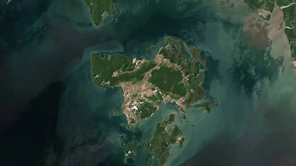
Pulau Rupat In The Malacca Strait On A Satellite Image Taken In February 28, 2020
Image, 4.98MB, 2880 × 1620 jpg


Ko Yao Yai Island In The Malacca Strait - Belonging To Thailand. Described Location Diagram With Yellow Shape Of The Island And Sample Maps Of Its Surroundings
Image, 2.73MB, 3840 × 2160 jpg

Pulau Bengkalis In The Malacca Strait - Belonging To Indonesia. Described Location Diagram With Yellow Shape Of The Island And Sample Maps Of Its Surroundings
Image, 2.7MB, 3840 × 2160 jpg

Ko Tarutao Island In The Malacca Strait, Belonging To Thailand, Isolated On A Topographic, OSM Humanitarian Style Map, With Distance Scale
Image, 0.27MB, 2160 × 2160 jpg

Ko Yao Yai Island In The Malacca Strait, Belonging To Thailand, Isolated On A Topographic, OSM Humanitarian Style Map, With Distance Scale
Image, 0.39MB, 2160 × 2160 jpg

Pulau Pandang In The Malacca Strait On A Topographic, OSM Humanitarian Style Map
Image, 3.09MB, 2880 × 1620 jpg

Ko Lanta Yai Island In The Malacca Strait On A Satellite Image Taken In February 26, 2020
Image, 4.31MB, 2880 × 1620 jpg

Ko Rawi Island In The Malacca Strait On A Satellite Image Taken In March 7, 2023
Image, 4.52MB, 2880 × 1620 jpg

Sumatra Island In The Java Sea, Belonging To Indonesia, Isolated On A Topographic, OSM Humanitarian Style Map, With Distance Scale
Image, 1.1MB, 2160 × 2160 jpg

Ko Lanta Noi Island In The Malacca Strait On A Topographic, OSM Humanitarian Style Map
Image, 1.07MB, 2880 × 1620 jpg

Sumatra Island In The Java Sea On A Topographic, OSM Humanitarian Style Map
Image, 2MB, 2880 × 1620 jpg

Pulau Dayang Bunting In The Malacca Strait, Belonging To Malaysia, Isolated On A Topographic, OSM Humanitarian Style Map, With Distance Scale
Image, 0.39MB, 2160 × 2160 jpg

Pulau Pandang In The Malacca Strait, Belonging To Indonesia, Isolated On A Bilevel Elevation Map, With Distance Scale
Image, 0.56MB, 2160 × 2160 jpg

Pulau Dayang Bunting In The Malacca Strait, Belonging To Malaysia, Isolated On A Satellite Image Taken In February 5, 2024, With Distance Scale
Image, 1.08MB, 2160 × 2160 jpg
Previous << Page 2 >> Next