photo free
Home Images Vectors Videos

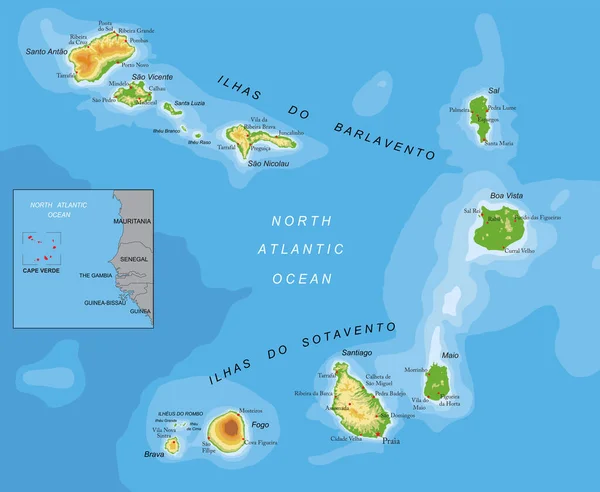
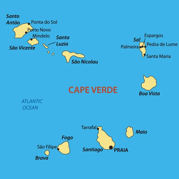
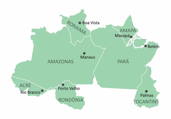
Stock image Map Of Boa Vista

stock image Roraima, state of Brazil. Colored relief with lakes and rivers. Shape presented against its country area with informative overlays. 3D rendering

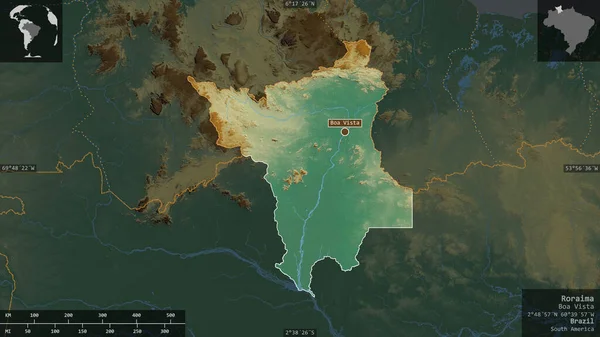
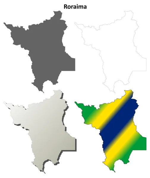
Roraima, State Of Brazil. Colored Relief With Lakes And Rivers. Shape Presented Against Its Country Area With Informative Overlays. 3D Rendering

Image, 5.09MB, 2880 × 1620 jpg
stock vector Cape Verde Political Map

Cape Verde Political Map

Vector, 0.91MB, 7135 × 6000 eps
stock vector Accurate map of Boa Vista

Accurate Map Of Boa Vista

Vector, 0.6MB, 5000 × 4000 eps
stock image Map of Cape Verde on a wall

Map Of Cape Verde On A Wall

Image, 5.78MB, 3600 × 2416 jpg
stock image Cabo Verde map on a wall in Santa Maria, Sal island

Cabo Verde Map On A Wall In Santa Maria, Sal Island

Image, 5.58MB, 3400 × 2267 jpg
stock vector The Roraima State regions map with labels on white background, Brazil

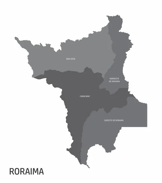
The Roraima State Regions Map With Labels On White Background, Brazil

Vector, 8.49MB, 4440 × 5000 eps
stock vector Roraima blank outline map set

Roraima Blank Outline Map Set

Vector, 0.4MB, 4658 × 5528 eps
stock vector Brazil north region

Brazil North Region

Vector, 8.39MB, 5000 × 3500 eps
stock vector Cape Verde highly detailed physical map

Cape Verde Highly Detailed Physical Map

Vector, 2.01MB, 7500 × 6155 eps
stock vector Boa Vista municipality (State of Roraima, Municipalities of Brazil, Federative Republic of Brazil) map vector illustration, scribble sketch Boa Vista map

Boa Vista Municipality (State Of Roraima, Municipalities Of Brazil, Federative Republic Of Brazil) Map Vector Illustration, Scribble Sketch Boa Vista Map

Vector, 1.28MB, 7087 × 4726 eps
stock vector Republic of Cabo Verde - vector map

Republic Of Cabo Verde - Vector Map

Vector, 0.19MB, 4225 × 4225 eps
stock vector Brazil north region map

Brazil North Region Map

Vector, 8.39MB, 5000 × 3500 eps
stock image Boa Vista Island in the North Atlantic Ocean on a satellite image taken in December 9, 2023

Boa Vista Island In The North Atlantic Ocean On A Satellite Image Taken In December 9, 2023

Image, 4.52MB, 2880 × 1620 jpg
stock image Boa Vista Island in the North Atlantic Ocean - belonging to Cape Verde. Described location diagram with yellow shape of the island and sample maps of its surroundings

Boa Vista Island In The North Atlantic Ocean - Belonging To Cape Verde. Described Location Diagram With Yellow Shape Of The Island And Sample Maps Of Its Surroundings

Image, 2.3MB, 3840 × 2160 jpg
stock image Boa Vista Island in the North Atlantic Ocean, belonging to Cape Verde, isolated on a bilevel elevation map, with distance scale

Boa Vista Island In The North Atlantic Ocean, Belonging To Cape Verde, Isolated On A Bilevel Elevation Map, With Distance Scale

Image, 0.66MB, 2160 × 2160 jpg
stock image Boa Vista Island in the North Atlantic Ocean on a topographic, OSM Humanitarian style map

Boa Vista Island In The North Atlantic Ocean On A Topographic, OSM Humanitarian Style Map

Image, 0.85MB, 2880 × 1620 jpg
stock image Boa Vista Island in the North Atlantic Ocean on a colored elevation map

Boa Vista Island In The North Atlantic Ocean On A Colored Elevation Map

Image, 1.29MB, 2880 × 1620 jpg
stock image Boa Vista Island in the North Atlantic Ocean, belonging to Cape Verde, isolated on a satellite image taken in January 28, 2024, with distance scale

Boa Vista Island In The North Atlantic Ocean, Belonging To Cape Verde, Isolated On A Satellite Image Taken In January 28, 2024, With Distance Scale

Image, 2.32MB, 2160 × 2160 jpg
stock image Boa Vista Island in the North Atlantic Ocean, belonging to Cape Verde, isolated on a topographic, OSM Humanitarian style map, with distance scale

Boa Vista Island In The North Atlantic Ocean, Belonging To Cape Verde, Isolated On A Topographic, OSM Humanitarian Style Map, With Distance Scale

Image, 1.22MB, 2160 × 2160 jpg
Page 1 >> Next