photo free
Home Images Vectors Videos

Stock image Map Of Raiatea

stock vector Map of the French Polynesian Archipelago Leeward Islands (Society Islands), France

Map Of The French Polynesian Archipelago Leeward Islands (Society Islands), France

Vector, 0.8MB, 4378 × 3100 eps
stock vector Vector map of the Leeward Islands belonging to the French Society Islands

Vector Map Of The Leeward Islands Belonging To The French Society Islands

Vector, 1.79MB, 5426 × 3100 eps
stock vector Society Islands, political map. Group of volcanic islands, in French Polynesia, an overseas collectivity of France, in the South Pacific Ocean. Archipelago, divided into Leeward and Windward Islands.

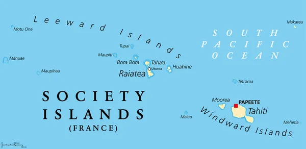
Society Islands, Political Map. Group Of Volcanic Islands, In French Polynesia, An Overseas Collectivity Of France, In The South Pacific Ocean. Archipelago, Divided Into Leeward And Windward Islands.

Vector, 2.25MB, 9000 × 4391 eps
stock image Raiatea Island in the South Pacific Ocean on a topographic, OSM Humanitarian style map

Raiatea Island In The South Pacific Ocean On A Topographic, OSM Humanitarian Style Map

Image, 0.52MB, 2880 × 1620 jpg
stock image Raiatea Island in the South Pacific Ocean on a colored elevation map

Raiatea Island In The South Pacific Ocean On A Colored Elevation Map

Image, 1.04MB, 2880 × 1620 jpg
stock image Raiatea Island in the South Pacific Ocean - belonging to France. Described location diagram with yellow shape of the island and sample maps of its surroundings

Raiatea Island In The South Pacific Ocean - Belonging To France. Described Location Diagram With Yellow Shape Of The Island And Sample Maps Of Its Surroundings

Image, 1.87MB, 3840 × 2160 jpg
stock image Raiatea Island in the South Pacific Ocean on a satellite image taken in July 10, 2018

Raiatea Island In The South Pacific Ocean On A Satellite Image Taken In July 10, 2018

Image, 4.94MB, 2880 × 1620 jpg
stock image Raiatea Island in the South Pacific Ocean, belonging to France, isolated on a satellite image taken in June 9, 2023, with distance scale

Raiatea Island In The South Pacific Ocean, Belonging To France, Isolated On A Satellite Image Taken In June 9, 2023, With Distance Scale

Image, 1.46MB, 2160 × 2160 jpg
stock image Raiatea Island in the South Pacific Ocean, belonging to France, isolated on a topographic, OSM Humanitarian style map, with distance scale

Raiatea Island In The South Pacific Ocean, Belonging To France, Isolated On A Topographic, OSM Humanitarian Style Map, With Distance Scale

Image, 0.71MB, 2160 × 2160 jpg
stock image Raiatea Island in the South Pacific Ocean, belonging to France, isolated on a bilevel elevation map, with distance scale

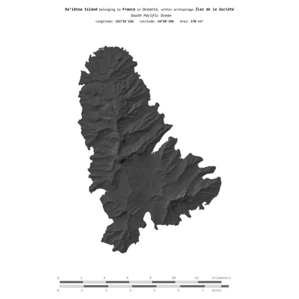
Raiatea Island In The South Pacific Ocean, Belonging To France, Isolated On A Bilevel Elevation Map, With Distance Scale

Image, 0.46MB, 2160 × 2160 jpg
Page 1 >> Next