photo free
Home Images Vectors Videos

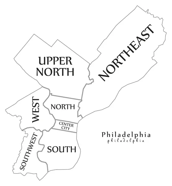
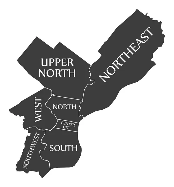
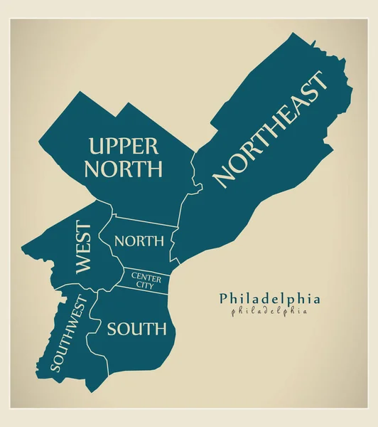
Stock image Philadelphia County page 2

stock vector Pennsylvania map

Pennsylvania Map

Vector, 3.92MB, 5004 × 4848 eps
stock image skyline at night of philadelphia pennsylvania from above schulyk

Skyline At Night Of Philadelphia Pennsylvania From Above Schulyk

Image, 20.98MB, 6000 × 4000 jpg
stock vector Pennsylvania counties vector map with USA map colors national flag

Pennsylvania Counties Vector Map With USA Map Colors National Flag

Vector, 22.92MB, 4679 × 4024 eps
stock image sunset skyline of philadelphia pennsylvania from camden new jers

Sunset Skyline Of Philadelphia Pennsylvania From Camden New Jers

Image, 14.61MB, 6000 × 4000 jpg
stock image washington square in philadelphia pennsylvania in spring

Washington Square In Philadelphia Pennsylvania In Spring

Image, 23.08MB, 5892 × 3928 jpg
stock image Homes near rittenhouse square in philadelphia, pennsylvania

Homes Near Rittenhouse Square In Philadelphia, Pennsylvania

Image, 17.89MB, 6000 × 4000 jpg
stock image views in Dilworth park in center city philadelphia pennsylvania

Views In Dilworth Park In Center City Philadelphia Pennsylvania

Image, 15.81MB, 6000 × 4000 jpg
stock vector Pennsylvania County Map

Pennsylvania County Map

Vector, 0.75MB, 5000 × 3334 ai
stock vector Pennsylvania map

Pennsylvania Map

Vector, 10.16MB, 7002 × 7002 eps
stock vector Philadelphia city map with boroughs grey illustration silhouette

Philadelphia City Map With Boroughs Grey Illustration Silhouette

Vector, 3.98MB, 5000 × 5388 eps
stock vector Modern City Map - Philadelphia city of the USA with boroughs and

Modern City Map - Philadelphia City Of The USA With Boroughs And

Vector, 7.86MB, 5000 × 5402 eps
stock vector vector map of United States with indication of Pennsylvania

Vector Map Of United States With Indication Of Pennsylvania

Vector, 2.23MB, 4600 × 3450 eps
stock vector Vector hand drawn stylized map of The United States of America. Travel illustration of USA cities. Hand drawn lettering illustration. North America map element

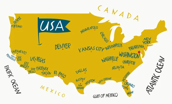
Vector Hand Drawn Stylized Map Of The United States Of America. Travel Illustration Of USA Cities. Hand Drawn Lettering Illustration. North America Map Element

Vector, 0.5MB, 6600 × 4000 eps
stock vector Philadelphia city map USA labelled black illustration

Philadelphia City Map USA Labelled Black Illustration

Vector, 5.65MB, 5000 × 5383 eps
stock image aerial of center city west in philadelphia pennsylvania during s

Aerial Of Center City West In Philadelphia Pennsylvania During S

Image, 13.53MB, 6000 × 4000 jpg
stock vector Blue map of Pennsylvania with indication of Harrisburg

Blue Map Of Pennsylvania With Indication Of Harrisburg

Vector, 1.37MB, 4800 × 3360 eps
stock vector Yellow map of Pennsylvania with indication of largest cities

Yellow Map Of Pennsylvania With Indication Of Largest Cities

Vector, 1.43MB, 4800 × 3360 eps
stock vector USA travel landmarks icon of architectural sights

USA Travel Landmarks Icon Of Architectural Sights

Vector, 0.83MB, 5556 × 5556 eps
stock vector Grey map of Pennsylvania

Grey Map Of Pennsylvania

Vector, 1.35MB, 4800 × 3360 eps
stock vector Pennsylvania state detailed editable map

Pennsylvania State Detailed Editable Map

Vector, 0.98MB, 6915 × 4643 eps
stock vector Pennsylvania administrative and political vector map

Pennsylvania Administrative And Political Vector Map

Vector, 1.36MB, 4394 × 3100 eps
stock image Aerial Sunny Isles Beach Miami Dade Florida panorama highrise beachfront architecture

Aerial Sunny Isles Beach Miami Dade Florida Panorama Highrise Beachfront Architecture

Image, 20.91MB, 15000 × 2444 jpg
stock vector abstract outline of Pennsylvania map

Abstract Outline Of Pennsylvania Map

Vector, 1.36MB, 4800 × 3360 eps
stock vector Pennsylvania county map

Pennsylvania County Map

Vector, 1.96MB, 5000 × 3334 ai
stock vector Black map of Pennsylvania

Black Map Of Pennsylvania

Vector, 1.35MB, 4800 × 3360 eps
stock image Spring in rittenhouse square in philadelphia pennsylvania

Spring In Rittenhouse Square In Philadelphia Pennsylvania

Image, 23.25MB, 6000 × 4000 jpg
stock vector Pennsylvania USA state map vector tag cloud illustration

Pennsylvania USA State Map Vector Tag Cloud Illustration

Vector, 9.07MB, 12638 × 6477 eps
stock vector Modern City Map - Philadelphia city of the USA with boroughs and

Modern City Map - Philadelphia City Of The USA With Boroughs And

Vector, 7.73MB, 5000 × 5638 eps
stock vector Set 1 of 5 Highly detailed vector silhouettes of USA state maps

Set 1 Of 5 Highly Detailed Vector Silhouettes Of USA State Maps

Vector, 4.79MB, 8858 × 3738 eps
stock vector blue abstract outline of Pennsylvania map

Blue Abstract Outline Of Pennsylvania Map

Vector, 1.35MB, 4800 × 3360 eps
stock vector Highly detailed vector silhouettes of US state maps, Division United States into counties, political and geographic subdivisions of a states, Mid-Atlantic - Pennsylvania, New Jersey, New York - set 3 of 17

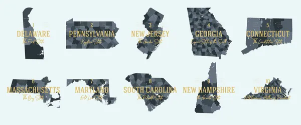
Highly Detailed Vector Silhouettes Of US State Maps, Division United States Into Counties, Political And Geographic Subdivisions Of A States, Mid-Atlantic - Pennsylvania, New Jersey, New York - Set 3 Of 17

Vector, 8.56MB, 9608 × 4501 eps
stock image Photo of a rare breed turkey.

Photo Of A Rare Breed Turkey.

Image, 4.23MB, 5184 × 3456 jpg
stock image Green Frog in a wetland

Green Frog In A Wetland

Image, 9.2MB, 5760 × 3840 jpg
stock vector Set 1 of 5 Division United States into counties, political and geographic subdivisions of a states, Highly detailed vector maps with names and territory nicknames

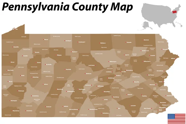
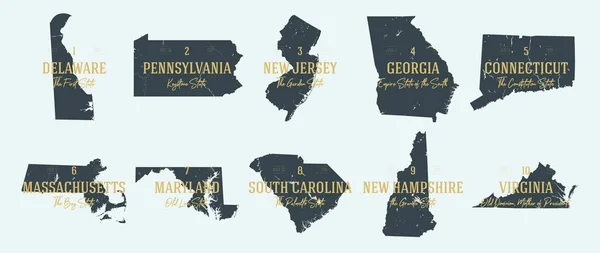
Set 1 Of 5 Division United States Into Counties, Political And Geographic Subdivisions Of A States, Highly Detailed Vector Maps With Names And Territory Nicknames

Vector, 5.93MB, 9585 × 4010 eps
stock image Two turkeys

Two Turkeys

Image, 3.66MB, 3029 × 2013 jpg
stock image Green Frog, Lithobates clamitans, on log in a pond

Green Frog, Lithobates Clamitans, On Log In A Pond

Image, 4.04MB, 4928 × 3264 jpg
stock image Green Frog in a wetland

Green Frog In A Wetland

Image, 9.24MB, 5760 × 3840 jpg
stock image Bonaparte's Gull (Chroicocephalus philadelphia ) soaring over a Lake Huron Beach in autumn - Grand Bend, Ontario, Canada

Bonaparte's Gull (Chroicocephalus Philadelphia ) Soaring Over A Lake Huron Beach In Autumn - Grand Bend, Ontario, Canada

Image, 0MB, 4082 × 2400 jpg
stock vector Pennsylvania counties, gray political map. Commonwealth of Pennsylvania, a state of the Mid-Atlantic and Northeastern United States, subdivided into 67 counties. Map with boundaries and county names.

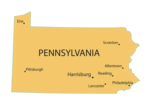
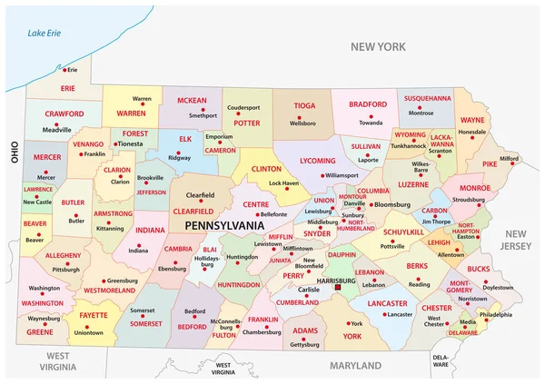
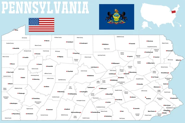
Pennsylvania Counties, Gray Political Map. Commonwealth Of Pennsylvania, A State Of The Mid-Atlantic And Northeastern United States, Subdivided Into 67 Counties. Map With Boundaries And County Names.

Vector, 2.09MB, 9000 × 5702 eps
stock vector Highly Detailed Pennsylvania Blind Map.

Highly Detailed Pennsylvania Blind Map.

Vector, 5.85MB, 4219 × 2886 eps
stock vector Pennsylvania counties, political map. Commonwealth of Pennsylvania, a state of the Mid-Atlantic and Northeastern United States, subdivided into 67 counties. Map with boundaries and county names.

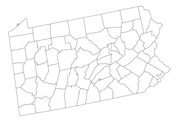
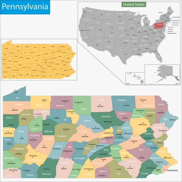
Pennsylvania Counties, Political Map. Commonwealth Of Pennsylvania, A State Of The Mid-Atlantic And Northeastern United States, Subdivided Into 67 Counties. Map With Boundaries And County Names.

Vector, 2.65MB, 9000 × 6000 eps
stock image Spring in rittenhouse square in philadelphia pennsylvania

Spring In Rittenhouse Square In Philadelphia Pennsylvania

Image, 22.92MB, 6000 × 4000 jpg
stock image Map of philadelphia County in Pennsylvania state on white background. single County map highlighted by black colour on Pennsylvania map. UNITED STATES, US

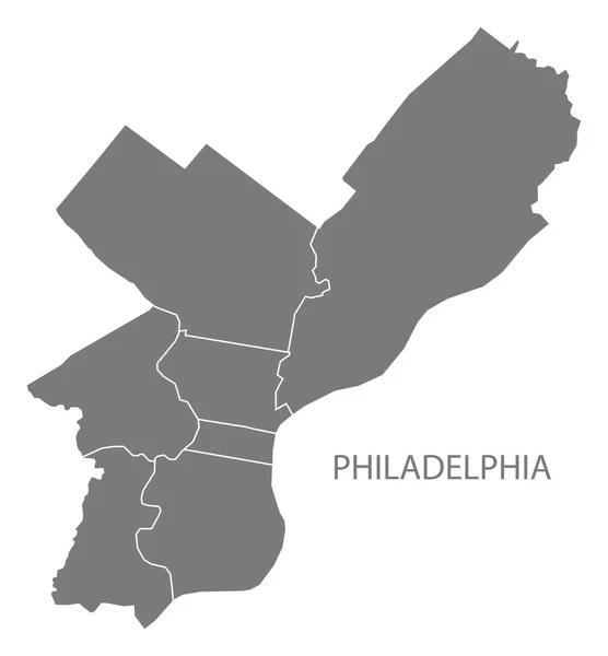
Map Of Philadelphia County In Pennsylvania State On White Background. Single County Map Highlighted By Black Colour On Pennsylvania Map. UNITED STATES, US

Image, 4.23MB, 8000 × 5334 jpg
Previous << Page 2 >> Next