photo free
Home Images Vectors Videos

Stock image San Andres Map

stock vector San Andres map vintage stamp Retro style handmade label badge or element for travel souvenirs

San Andres Map Vintage Stamp Retro Style Handmade Label Badge Or Element For Travel Souvenirs

Vector, 5.28MB, 5480 × 5480 eps
stock vector San Andres high detailed map Island silhouette icon Isolated San Andres black map outline Vector

San Andres High Detailed Map Island Silhouette Icon Isolated San Andres Black Map Outline Vector

Vector, 0.34MB, 8805 × 9418 eps
stock vector San Andres, Providencia and santa catalina road map

San Andres, Providencia And Santa Catalina Road Map

Vector, 0MB, 4000 × 3952 zip
stock vector San Andres, Providencia and santa catalina road map

San Andres, Providencia And Santa Catalina Road Map

Vector, 1.21MB, 3462 × 3100 eps
stock vector Map of the Colombian islands of san andres and providencia

Map Of The Colombian Islands Of San Andres And Providencia

Vector, 1.42MB, 3460 × 3100 eps
stock vector San Andres icon Shape of the island with San Andres flag Round sign with flag colors gradient

San Andres Icon Shape Of The Island With San Andres Flag Round Sign With Flag Colors Gradient

Vector, 0.26MB, 5488 × 5488 eps
stock vector San Andres vector map Grunge rubber stamp with the name and map of island vector illustration Can

San Andres Vector Map Grunge Rubber Stamp With The Name And Map Of Island Vector Illustration Can

Vector, 4.02MB, 8350 × 8350 eps
stock image Isla de San Andres in the Caribbean Sea, belonging to Colombia, isolated on a satellite image taken in January 17, 2023, with distance scale

Isla De San Andres In The Caribbean Sea, Belonging To Colombia, Isolated On A Satellite Image Taken In January 17, 2023, With Distance Scale

Image, 0.84MB, 2160 × 2160 jpg
stock image Isla de San Andres in the Caribbean Sea on a colored elevation map

Isla De San Andres In The Caribbean Sea On A Colored Elevation Map

Image, 0.65MB, 2880 × 1620 jpg
stock image Isla de San Andres in the Caribbean Sea on a topographic, OSM Humanitarian style map

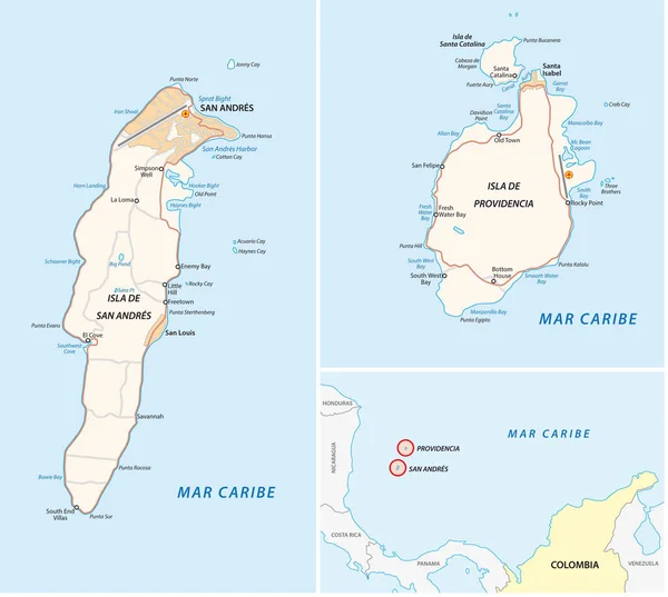
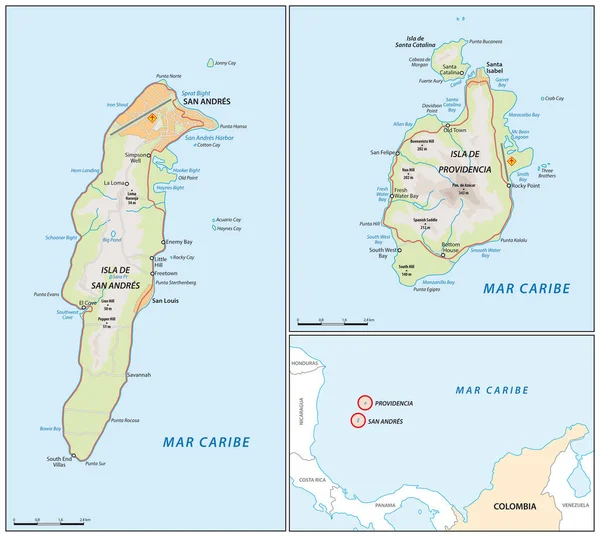
Isla De San Andres In The Caribbean Sea On A Topographic, OSM Humanitarian Style Map

Image, 0.46MB, 2880 × 1620 jpg
stock image Isla de San Andres in the Caribbean Sea on a satellite image taken in May 17, 2021

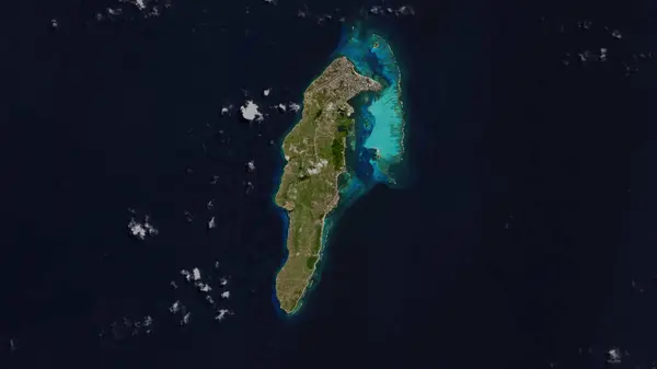
Isla De San Andres In The Caribbean Sea On A Satellite Image Taken In May 17, 2021

Image, 4.35MB, 2880 × 1620 jpg
stock image Isla de San Andres in the Caribbean Sea - belonging to Colombia. Described location diagram with yellow shape of the island and sample maps of its surroundings

Isla De San Andres In The Caribbean Sea - Belonging To Colombia. Described Location Diagram With Yellow Shape Of The Island And Sample Maps Of Its Surroundings

Image, 1.75MB, 3840 × 2160 jpg
stock image Isla de San Andres in the Caribbean Sea, belonging to Colombia, isolated on a topographic, OSM Humanitarian style map, with distance scale

Isla De San Andres In The Caribbean Sea, Belonging To Colombia, Isolated On A Topographic, OSM Humanitarian Style Map, With Distance Scale

Image, 0.66MB, 2160 × 2160 jpg
stock image Isla de San Andres in the Caribbean Sea, belonging to Colombia, isolated on a bilevel elevation map, with distance scale

Isla De San Andres In The Caribbean Sea, Belonging To Colombia, Isolated On A Bilevel Elevation Map, With Distance Scale

Image, 0.23MB, 2160 × 2160 jpg
stock vector San Andres de Giles department (Buenos Aires) outline map set

San Andres De Giles Department (Buenos Aires) Outline Map Set

Vector, 0.25MB, 6000 × 3000 eps
Page 1 >> Next