
Stock image Seto Naikai page 2

Honshu Island In The Japan Sea, Belonging To Japan, Isolated On A Satellite Image Taken In March 17, 2016, With Distance Scale
Image, 1.12MB, 2160 × 2160 jpg

Kurahashi Island In The Seto Naikai Or Inland Sea - Belonging To Japan. Described Location Diagram With Yellow Shape Of The Island And Sample Maps Of Its Surroundings
Image, 2.73MB, 3840 × 2160 jpg

Yashiro Island In The Seto Naikai Or Inland Sea On A Colored Elevation Map
Image, 2.11MB, 2880 × 1620 jpg

Kyushu Island In The Japan Sea - Belonging To Japan. Described Location Diagram With Yellow Shape Of The Island And Sample Maps Of Its Surroundings
Image, 2.86MB, 3840 × 2160 jpg

Awajishima Island In The Philippine Sea, Belonging To Japan, Isolated On A Satellite Image Taken In February 12, 2023, With Distance Scale
Image, 1.35MB, 2160 × 2160 jpg

Osakikami Island In The Seto Naikai Or Inland Sea On A Topographic, OSM Humanitarian Style Map
Image, 2.29MB, 2880 × 1620 jpg

Omishima Island In The Seto Naikai Or Inland Sea, Belonging To Japan, Isolated On A Bilevel Elevation Map, With Distance Scale
Image, 0.43MB, 2160 × 2160 jpg

Mukaishima Island In The Seto Naikai Or Inland Sea, Belonging To Japan, Isolated On A Topographic, OSM Humanitarian Style Map, With Distance Scale
Image, 1.38MB, 2160 × 2160 jpg

Shikoku Island In The Japan Sea On A Satellite Image Taken In February 22, 2021
Image, 4.19MB, 2880 × 1620 jpg

Shodoshima Island In The Seto Naikai Or Inland Sea On A Topographic, OSM Humanitarian Style Map
Image, 2.04MB, 2880 × 1620 jpg

Shodoshima Island In The Seto Naikai Or Inland Sea, Belonging To Japan, Isolated On A Bilevel Elevation Map, With Distance Scale
Image, 0.46MB, 2160 × 2160 jpg

Kurahashi Island In The Seto Naikai Or Inland Sea, Belonging To Japan, Isolated On A Bilevel Elevation Map, With Distance Scale
Image, 0.43MB, 2160 × 2160 jpg

Kyushu Island In The Japan Sea, Belonging To Japan, Isolated On A Bilevel Elevation Map, With Distance Scale
Image, 0.82MB, 2160 × 2160 jpg

Kyushu Island In The Japan Sea On A Satellite Image Taken In February 22, 2021
Image, 2.58MB, 2880 × 1620 jpg

Kurahashi Island In The Seto Naikai Or Inland Sea On A Satellite Image Taken In April 28, 2022
Image, 5.83MB, 2880 × 1620 jpg


Ikuchi Island In The Seto Naikai Or Inland Sea, Belonging To Japan, Isolated On A Topographic, OSM Humanitarian Style Map, With Distance Scale
Image, 1.49MB, 2160 × 2160 jpg


Etajima In The Seto Naikai Or Inland Sea, Belonging To Japan, Isolated On A Bilevel Elevation Map, With Distance Scale
Image, 0.31MB, 2160 × 2160 jpg

Osakikami Island In The Seto Naikai Or Inland Sea On A Satellite Image Taken In July 27, 2021
Image, 4.98MB, 2880 × 1620 jpg

Shikoku Island In The Japan Sea On A Topographic, OSM Humanitarian Style Map
Image, 4.5MB, 2880 × 1620 jpg

Awajishima Island In The Philippine Sea On A Satellite Image Taken In May 3, 2023
Image, 5.68MB, 2880 × 1620 jpg

Mukaishima Island In The Seto Naikai Or Inland Sea On A Topographic, OSM Humanitarian Style Map
Image, 2.85MB, 2880 × 1620 jpg

Shikoku Island In The Japan Sea, Belonging To Japan, Isolated On A Bilevel Elevation Map, With Distance Scale
Image, 0.74MB, 2160 × 2160 jpg

Innoshima Island In The Seto Naikai Or Inland Sea, Belonging To Japan, Isolated On A Bilevel Elevation Map, With Distance Scale
Image, 0.36MB, 2160 × 2160 jpg
Awajishima Island In The Philippine Sea, Belonging To Japan, Isolated On A Topographic, OSM Humanitarian Style Map, With Distance Scale
Image, 1.08MB, 2160 × 2160 jpg

Honshu Island In The Japan Sea, Belonging To Japan, Isolated On A Bilevel Elevation Map, With Distance Scale
Image, 0.62MB, 2160 × 2160 jpg

Omishima Island In The Seto Naikai Or Inland Sea - Belonging To Japan. Described Location Diagram With Yellow Shape Of The Island And Sample Maps Of Its Surroundings
Image, 3.23MB, 3840 × 2160 jpg
Itsukushima Island In The Seto Naikai Or Inland Sea On A Satellite Image Taken In May 21, 2023
Image, 7.04MB, 2880 × 1620 jpg

Omishima Island In The Seto Naikai Or Inland Sea On A Topographic, OSM Humanitarian Style Map
Image, 3.21MB, 2880 × 1620 jpg

Mukaishima Island In The Seto Naikai Or Inland Sea On A Colored Elevation Map
Image, 1.47MB, 2880 × 1620 jpg
Osakikami Island In The Seto Naikai Or Inland Sea On A Colored Elevation Map
Image, 1.69MB, 2880 × 1620 jpg

Noumishima Island In The Seto Naikai Or Inland Sea, Belonging To Japan, Isolated On A Satellite Image Taken In November 27, 2022, With Distance Scale
Image, 1.31MB, 2160 × 2160 jpg

Honshu Island In The Japan Sea - Belonging To Japan. Described Location Diagram With Yellow Shape Of The Island And Sample Maps Of Its Surroundings
Image, 3.12MB, 3840 × 2160 jpg
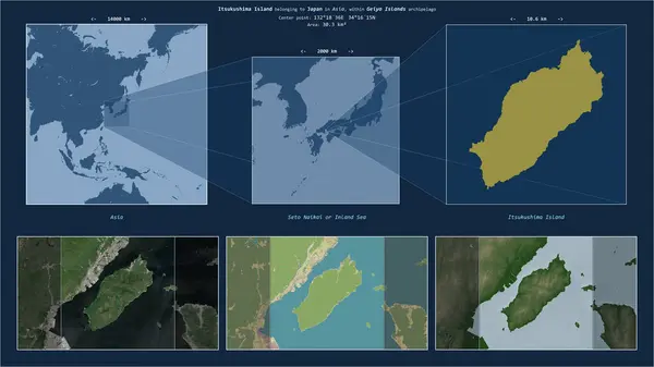
Itsukushima Island In The Seto Naikai Or Inland Sea - Belonging To Japan. Described Location Diagram With Yellow Shape Of The Island And Sample Maps Of Its Surroundings
Image, 2.84MB, 3840 × 2160 jpg

Shodoshima Island In The Seto Naikai Or Inland Sea - Belonging To Japan. Described Location Diagram With Yellow Shape Of The Island And Sample Maps Of Its Surroundings
Image, 2.57MB, 3840 × 2160 jpg

Ikuchi Island In The Seto Naikai Or Inland Sea On A Satellite Image Taken In November 5, 2019
Image, 6.42MB, 2880 × 1620 jpg

Osakikami Island In The Seto Naikai Or Inland Sea - Belonging To Japan. Described Location Diagram With Yellow Shape Of The Island And Sample Maps Of Its Surroundings
Image, 2.93MB, 3840 × 2160 jpg

Oshima Island In The Seto Naikai Or Inland Sea - Belonging To Japan. Described Location Diagram With Yellow Shape Of The Island And Sample Maps Of Its Surroundings
Image, 2.65MB, 3840 × 2160 jpg

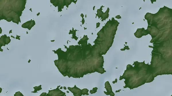
Yashiro Island In The Seto Naikai Or Inland Sea, Belonging To Japan, Isolated On A Bilevel Elevation Map, With Distance Scale
Image, 0.35MB, 2160 × 2160 jpg

Yashiro Island In The Seto Naikai Or Inland Sea - Belonging To Japan. Described Location Diagram With Yellow Shape Of The Island And Sample Maps Of Its Surroundings
Image, 2.9MB, 3840 × 2160 jpg

Itsukushima Island In The Seto Naikai Or Inland Sea, Belonging To Japan, Isolated On A Bilevel Elevation Map, With Distance Scale
Image, 0.37MB, 2160 × 2160 jpg

Innoshima Island In The Seto Naikai Or Inland Sea On A Colored Elevation Map
Image, 1.61MB, 2880 × 1620 jpg

Honshu Island In The Japan Sea On A Topographic, OSM Humanitarian Style Map
Image, 2.45MB, 2880 × 1620 jpg

Ikuchi Island In The Seto Naikai Or Inland Sea On A Topographic, OSM Humanitarian Style Map
Image, 3.25MB, 2880 × 1620 jpg

Innoshima Island In The Seto Naikai Or Inland Sea On A Topographic, OSM Humanitarian Style Map
Image, 2.65MB, 2880 × 1620 jpg

Nakajima In The Seto Naikai Or Inland Sea, Belonging To Japan, Isolated On A Satellite Image Taken In October 30, 2023, With Distance Scale
Image, 1.41MB, 2160 × 2160 jpg

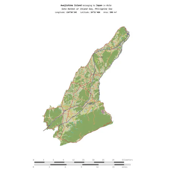
Awajishima Island In The Philippine Sea On A Topographic, OSM Humanitarian Style Map
Image, 3.44MB, 2880 × 1620 jpg

Yashiro Island In The Seto Naikai Or Inland Sea, Belonging To Japan, Isolated On A Topographic, OSM Humanitarian Style Map, With Distance Scale
Image, 0.73MB, 2160 × 2160 jpg

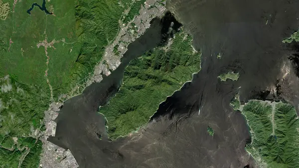
Nakajima In The Seto Naikai Or Inland Sea On A Satellite Image Taken In July 27, 2021
Image, 4.12MB, 2880 × 1620 jpg
Previous << Page 2 >> Next