photo free
Home Images Vectors Videos

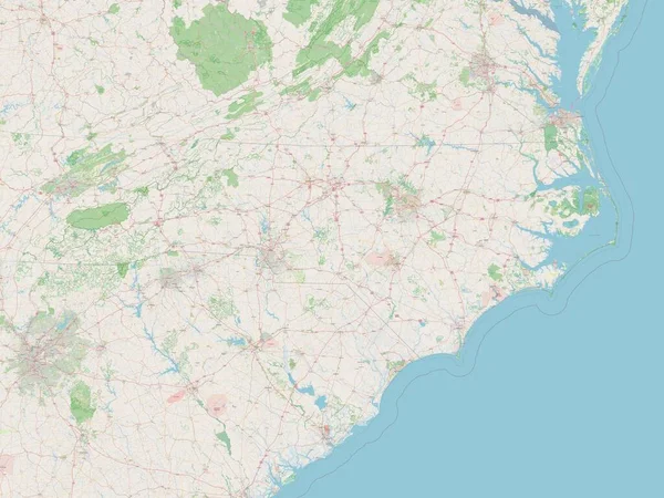
Stock image State High Point

stock vector North Carolina County Map

North Carolina County Map

Vector, 1.09MB, 5864 × 3000 ai
stock vector North Carolina County Map

North Carolina County Map

Vector, 1.18MB, 5000 × 3077 ai
stock vector North Carolina, NC, gray political map. With capital Raleigh and largest cities. State in the southeastern region of the United States of America. Old North State. Tar Heel State. Illustration. Vector

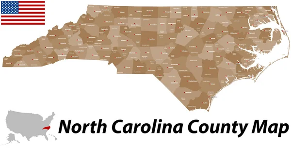
North Carolina, NC, Gray Political Map. With Capital Raleigh And Largest Cities. State In The Southeastern Region Of The United States Of America. Old North State. Tar Heel State. Illustration. Vector

Vector, 2.31MB, 9000 × 4674 eps
stock vector North Carolina, NC, political map. With the capital Raleigh and largest cities. State in the southeastern region of the United States of America. Old North State. Tar Heel State. Illustration. Vector.

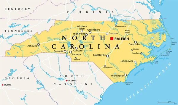
North Carolina, NC, Political Map. With The Capital Raleigh And Largest Cities. State In The Southeastern Region Of The United States Of America. Old North State. Tar Heel State. Illustration. Vector.

Vector, 5.04MB, 9000 × 5331 eps
stock image igh Point war veterans monument

Igh Point War Veterans Monument

Image, 19.92MB, 3840 × 5760 jpg
stock image High Point State Park Veterans Memorial Monument, NJ.

High Point State Park Veterans Memorial Monument, NJ.

Image, 6.8MB, 3072 × 4608 jpg
stock vector North Carolina vector flag. Vector illustration. United States of America. Raleigh

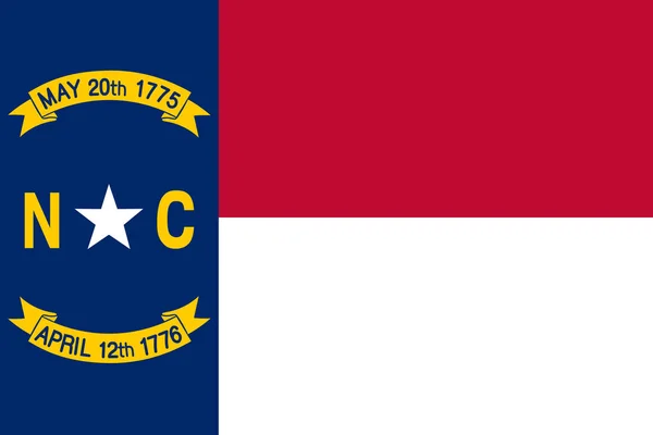
North Carolina Vector Flag. Vector Illustration. United States Of America. Raleigh

Vector, 0.73MB, 6000 × 4000 eps
stock image Krakow, Poland 20.09.2019: View of European city from a high point, bright different clouds against the blue sky.

Krakow, Poland 20.09.2019: View Of European City From A High Point, Bright Different Clouds Against The Blue Sky.

Image, 4.03MB, 4016 × 3008 jpg
stock image North Carolina state flag. Waving flag of North Carolina  state, United States of America. 3D Illustration

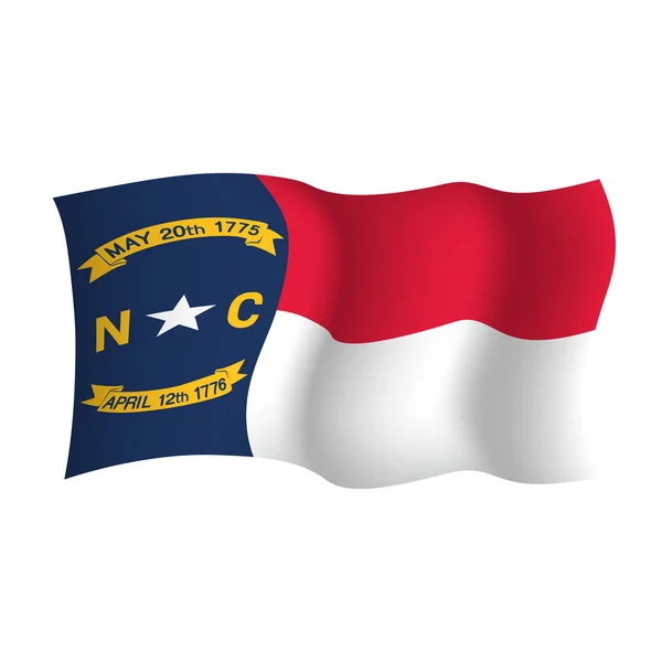
North Carolina State Flag. Waving Flag Of North Carolina State, United States Of America. 3D Illustration

Image, 3.72MB, 3556 × 2000 jpg
stock image Alpine scene in the Adirondacks Mountains, New York

Alpine Scene In The Adirondacks Mountains, New York

Image, 15.41MB, 3911 × 5925 jpg
stock image Alpine scene in the Adirondacks Mountains, New York

Alpine Scene In The Adirondacks Mountains, New York

Image, 22.52MB, 6145 × 4098 jpg
stock image Panorama of urban landscape of Juiz de Fora

Panorama Of Urban Landscape Of Juiz De Fora

Image, 46.99MB, 22496 × 5520 jpg
stock image Alpine scene in the Adirondacks Mountains, New York

Alpine Scene In The Adirondacks Mountains, New York

Image, 19.79MB, 6011 × 4012 jpg
stock image Alpine scene in the Adirondacks Mountains, New York

Alpine Scene In The Adirondacks Mountains, New York

Image, 18.96MB, 6161 × 4112 jpg
stock vector Vector illustration of high point, USA

Vector Illustration Of High Point, USA

Vector, 3.38MB, 6250 × 4167 eps
stock image Woman enjoys the nature

Woman Enjoys The Nature

Image, 20.17MB, 5560 × 3707 jpg
stock image Alpine scene in the Adirondacks Mountains, New York

Alpine Scene In The Adirondacks Mountains, New York

Image, 23.6MB, 6145 × 4067 jpg
stock image North Carolina, state of United States of America. Open Street Map

North Carolina, State Of United States Of America. Open Street Map

Image, 7.15MB, 3840 × 2880 jpg
stock image Alpine scene in the Adirondacks Mountains, New York

Alpine Scene In The Adirondacks Mountains, New York

Image, 25.32MB, 6161 × 4112 jpg
stock image Aerial view of Port Jervis

Aerial View Of Port Jervis

Image, 17.72MB, 4639 × 3019 jpg
stock image High Point war veterans monument

High Point War Veterans Monument

Image, 25.45MB, 8203 × 3840 jpg
stock vector Vector illustration of high point, USA

Vector Illustration Of High Point, USA

Vector, 3.41MB, 5833 × 4167 eps
stock image The Principality of Monaco. View of the harbor , yachts and residential areas with a high point

The Principality Of Monaco. View Of The Harbor , Yachts And Residential Areas With A High Point

Image, 8.22MB, 4000 × 2667 jpg
stock image North Carolina US state flag depicted on folded wavy fabric of old cloth close up

North Carolina US State Flag Depicted On Folded Wavy Fabric Of Old Cloth Close Up

Image, 7.28MB, 4928 × 3264 jpg
stock image North Carolina US state flag with big folds waving close up under the studio light indoors. The official symbols and colors in fabric banner

North Carolina US State Flag With Big Folds Waving Close Up Under The Studio Light Indoors. The Official Symbols And Colors In Fabric Banner

Image, 13.98MB, 6000 × 4000 jpg
stock image Lake Marcia in High Point state park, Kittatinny mountains, New Jersey. High Point is the highest elevation in the NJ state at 1,803 feet 550 m

Lake Marcia In High Point State Park, Kittatinny Mountains, New Jersey. High Point Is The Highest Elevation In The NJ State At 1,803 Feet 550 M

Image, 29.23MB, 5839 × 3451 jpg
stock image Aerial view of Vista House at Crown Point in Columbia Gorge, Oregon. The historic stone building with a golden dome overlooks a winding river and lush landscapes, bathed in tranquil early morning

Aerial View Of Vista House At Crown Point In Columbia Gorge, Oregon. The Historic Stone Building With A Golden Dome Overlooks A Winding River And Lush Landscapes, Bathed In Tranquil Early Morning

Image, 15.1MB, 5272 × 2962 jpg
stock image North Carolina US state flag depicted on folded wavy fabric of old cloth close up

North Carolina US State Flag Depicted On Folded Wavy Fabric Of Old Cloth Close Up

Image, 6.95MB, 4928 × 3264 jpg
stock vector The Carolinas or Carolina, the U.S. states North Carolina and South Carolina, political map, with borders and capitals Raleigh and Columbia. Bordered by Virginia, Tennessee, Georgia, and the Atlantic.

The Carolinas Or Carolina, The U.S. States North Carolina And South Carolina, Political Map, With Borders And Capitals Raleigh And Columbia. Bordered By Virginia, Tennessee, Georgia, And The Atlantic.

Vector, 4.05MB, 8806 × 6000 eps
stock image North Carolina US state flag depicted on folded wavy fabric of old cloth close up

North Carolina US State Flag Depicted On Folded Wavy Fabric Of Old Cloth Close Up

Image, 7.03MB, 4928 × 3264 jpg
stock vector The Carolinas or simply Carolina, U.S. states North and South Carolina, gray political map, with borders and capitals Raleigh and Columbia. Bordered by Virginia, Tennessee, Georgia, and the Atlantic.

The Carolinas Or Simply Carolina, U.S. States North And South Carolina, Gray Political Map, With Borders And Capitals Raleigh And Columbia. Bordered By Virginia, Tennessee, Georgia, And The Atlantic.

Vector, 3.14MB, 8808 × 6000 eps
stock image North Carolina US state flag depicted on folded wavy fabric of old cloth close up

North Carolina US State Flag Depicted On Folded Wavy Fabric Of Old Cloth Close Up

Image, 7.65MB, 4928 × 3264 jpg
stock image North Carolina US state flag depicted on folded wavy fabric of old cloth close up

North Carolina US State Flag Depicted On Folded Wavy Fabric Of Old Cloth Close Up

Image, 5.52MB, 4928 × 3264 jpg
stock vector North Carolina waving vector flag. Vector illustration. USA

North Carolina Waving Vector Flag. Vector Illustration. USA

Vector, 24.16MB, 8000 × 8000 eps
stock image Modern high fire tower in the forest on the background of the sky.

Modern High Fire Tower In The Forest On The Background Of The Sky.

Image, 8.44MB, 5472 × 3648 jpg
stock vector Map of Ukraine in gray on a white background

Map Of Ukraine In Gray On A White Background

Vector, 0.8MB, 4167 × 4167 eps
stock image Aerial view of Redwood City port

Aerial View Of Redwood City Port

Image, 12.34MB, 3764 × 2974 jpg
stock image Text: Common Core

Text: Common Core

Image, 2.49MB, 5500 × 3647 jpg
stock vector Map of Peru network. Vector illustration. World map

Map Of Peru Network. Vector Illustration. World Map

Vector, 1.39MB, 6250 × 5000 eps
stock image Coin operated binocular at Mount Greylock

Coin Operated Binocular At Mount Greylock

Image, 6.73MB, 3743 × 2506 jpg
stock image Veterans War Memorial Tower at Mount Greylock

Veterans War Memorial Tower At Mount Greylock

Image, 7.08MB, 3642 × 2253 jpg
stock vector Activation energy vector illustration. Chemical explanation with example.

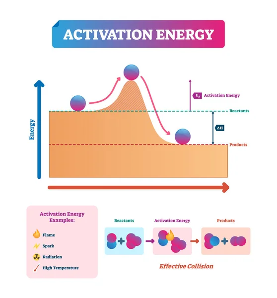
Activation Energy Vector Illustration. Chemical Explanation With Example.

Vector, 4.69MB, 4000 × 4299 eps
stock image Aerial photo of Salt Lake City

Aerial Photo Of Salt Lake City

Image, 12.89MB, 3930 × 2946 jpg
stock image Aerial view of Utah Salt Lake City downtown

Aerial View Of Utah Salt Lake City Downtown

Image, 11.26MB, 3940 × 2953 jpg
stock image Broken Hill in Torrey Pines State

Broken Hill In Torrey Pines State

Image, 7.42MB, 3800 × 2533 jpg
stock image View of Manhattan skyline

View Of Manhattan Skyline

Image, 4.21MB, 3731 × 3731 jpg
stock image View of Stanford Sattelite Dish from the air

View Of Stanford Sattelite Dish From The Air

Image, 8.89MB, 3760 × 2818 jpg
stock image Chicago street signs isolated over white

Chicago Street Signs Isolated Over White

Image, 3.42MB, 6588 × 3737 jpg
stock image Aerial photo of Sandy in Utah

Aerial Photo Of Sandy In Utah

Image, 12.73MB, 3992 × 2992 jpg
stock image Aerial photo Montgomery Plaza Fort Worth Texas

Aerial Photo Montgomery Plaza Fort Worth Texas

Image, 8.77MB, 4200 × 2798 jpg
Page 1 >> Next