
Stock image The Coastal Waters Of Southeast Alaska And British Columbia

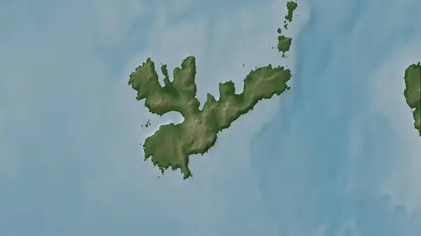
Duke Island In The The Coastal Waters Of Southeast Alaska And British Columbia On A Colored Elevation Map
Image, 1.54MB, 2880 × 1620 jpg

Douglas Island In The The Coastal Waters Of Southeast Alaska And British Columbia On A Colored Elevation Map
Image, 2.88MB, 2880 × 1620 jpg

Goat Island In The The Coastal Waters Of Southeast Alaska And British Columbia On A Colored Elevation Map
Image, 1.83MB, 2880 × 1620 jpg
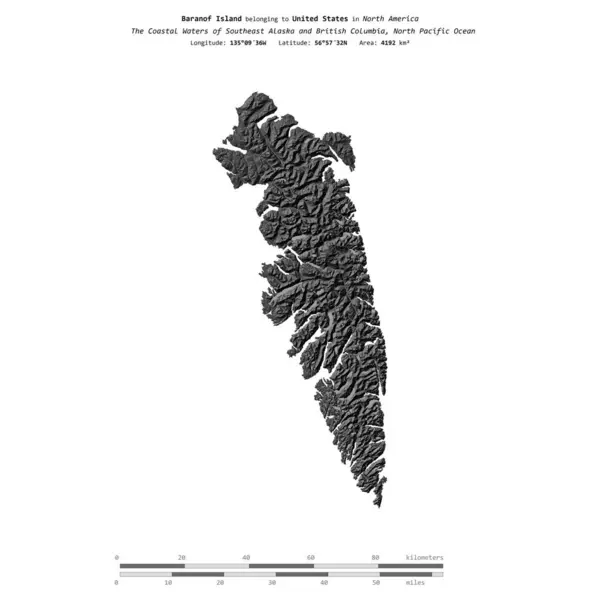
Baranof Island In The North Pacific Ocean, Belonging To United States, Isolated On A Bilevel Elevation Map, With Distance Scale
Image, 0.53MB, 2160 × 2160 jpg

Tuxekan Island In The The Coastal Waters Of Southeast Alaska And British Columbia - Belonging To United States. Described Location Diagram With Yellow Shape Of The Island And Sample Maps Of Its Surroundings
Image, 3.28MB, 3840 × 2160 jpg

Woronkofski Island In The The Coastal Waters Of Southeast Alaska And British Columbia - Belonging To United States. Described Location Diagram With Yellow Shape Of The Island And Sample Maps Of Its Surroundings
Image, 2.59MB, 3840 × 2160 jpg

Douglas Island In The The Coastal Waters Of Southeast Alaska And British Columbia, Belonging To United States, Isolated On A Topographic, OSM Humanitarian Style Map, With Distance Scale
Image, 0.36MB, 2160 × 2160 jpg

Shrubby Island In The The Coastal Waters Of Southeast Alaska And British Columbia On A Topographic, OSM Humanitarian Style Map
Image, 0.69MB, 2880 × 1620 jpg

Hassler Island In The The Coastal Waters Of Southeast Alaska And British Columbia On A Topographic, OSM Humanitarian Style Map
Image, 0.83MB, 2880 × 1620 jpg

Camano Island In The The Coastal Waters Of Southeast Alaska And British Columbia On A Topographic, OSM Humanitarian Style Map
Image, 3.48MB, 2880 × 1620 jpg

Lopez Island In The The Coastal Waters Of Southeast Alaska And British Columbia On A Topographic, OSM Humanitarian Style Map
Image, 2.49MB, 2880 × 1620 jpg

Cypress Island In The The Coastal Waters Of Southeast Alaska And British Columbia On A Topographic, OSM Humanitarian Style Map
Image, 1.15MB, 2880 × 1620 jpg

Kosciusko Island In The The Coastal Waters Of Southeast Alaska And British Columbia On A Topographic, OSM Humanitarian Style Map
Image, 1.52MB, 2880 × 1620 jpg

Moser Island In The The Coastal Waters Of Southeast Alaska And British Columbia On A Topographic, OSM Humanitarian Style Map
Image, 0.44MB, 2880 × 1620 jpg

Fir Island In The The Coastal Waters Of Southeast Alaska And British Columbia On A Satellite Image Taken In February 24, 2023
Image, 7.19MB, 2880 × 1620 jpg

Gravina Island In The The Coastal Waters Of Southeast Alaska And British Columbia On A Satellite Image Taken In July 20, 2018
Image, 5.72MB, 2880 × 1620 jpg

Heceta Island In The The Coastal Waters Of Southeast Alaska And British Columbia On A Satellite Image Taken In July 24, 2023
Image, 5.41MB, 2880 × 1620 jpg
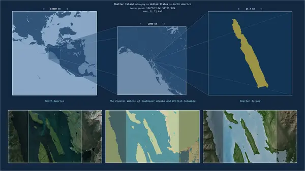
Shelter Island In The The Coastal Waters Of Southeast Alaska And British Columbia - Belonging To United States. Described Location Diagram With Yellow Shape Of The Island And Sample Maps Of Its Surroundings
Image, 2.73MB, 3840 × 2160 jpg

Pleasant Island In The The Coastal Waters Of Southeast Alaska And British Columbia - Belonging To United States. Described Location Diagram With Yellow Shape Of The Island And Sample Maps Of Its Surroundings
Image, 2.29MB, 3840 × 2160 jpg

Orcas Island In The The Coastal Waters Of Southeast Alaska And British Columbia On A Colored Elevation Map
Image, 2.13MB, 2880 × 1620 jpg

Vashon Island In The The Coastal Waters Of Southeast Alaska And British Columbia On A Colored Elevation Map
Image, 2.79MB, 2880 × 1620 jpg

Mary Island In The The Coastal Waters Of Southeast Alaska And British Columbia On A Colored Elevation Map
Image, 0.76MB, 2880 × 1620 jpg

Gravina Island In The The Coastal Waters Of Southeast Alaska And British Columbia, Belonging To United States, Isolated On A Topographic, OSM Humanitarian Style Map, With Distance Scale
Image, 0.37MB, 2160 × 2160 jpg

Anderson Island In The The Coastal Waters Of Southeast Alaska And British Columbia On A Colored Elevation Map
Image, 1.34MB, 2880 × 1620 jpg

Harstine Island In The The Coastal Waters Of Southeast Alaska And British Columbia - Belonging To United States. Described Location Diagram With Yellow Shape Of The Island And Sample Maps Of Its Surroundings
Image, 3.47MB, 3840 × 2160 jpg
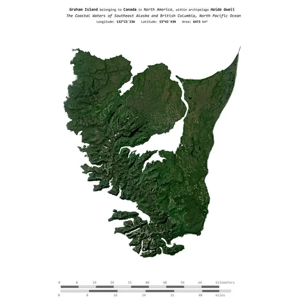
Graham Island In The North Pacific Ocean, Belonging To Canada, Isolated On A Satellite Image Taken In October 24, 2023, With Distance Scale
Image, 2MB, 2160 × 2160 jpg

Gravina Island In The The Coastal Waters Of Southeast Alaska And British Columbia, Belonging To United States, Isolated On A Satellite Image Taken In June 19, 2023, With Distance Scale
Image, 1.01MB, 2160 × 2160 jpg

Farm Island In The The Coastal Waters Of Southeast Alaska And British Columbia, Belonging To United States, Isolated On A Topographic, OSM Humanitarian Style Map, With Distance Scale
Image, 0.38MB, 2160 × 2160 jpg
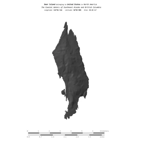
Deer Island In The The Coastal Waters Of Southeast Alaska And British Columbia, Belonging To United States, Isolated On A Bilevel Elevation Map, With Distance Scale
Image, 0.28MB, 2160 × 2160 jpg

Chichagof Island In The North Pacific Ocean, Belonging To United States, Isolated On A Satellite Image Taken In September 15, 2020, With Distance Scale
Image, 2.54MB, 2160 × 2160 jpg

Blakely Island In The The Coastal Waters Of Southeast Alaska And British Columbia On A Colored Elevation Map
Image, 1.16MB, 2880 × 1620 jpg

Brownson Island In The The Coastal Waters Of Southeast Alaska And British Columbia On A Colored Elevation Map
Image, 2.39MB, 2880 × 1620 jpg
Coronation Island In The The Coastal Waters Of Southeast Alaska And British Columbia On A Colored Elevation Map
Image, 1MB, 2880 × 1620 jpg

Brownson Island In The The Coastal Waters Of Southeast Alaska And British Columbia, Belonging To United States, Isolated On A Bilevel Elevation Map, With Distance Scale
Image, 0.29MB, 2160 × 2160 jpg

Kuiu Island In The The Coastal Waters Of Southeast Alaska And British Columbia, Belonging To United States, Isolated On A Topographic, OSM Humanitarian Style Map, With Distance Scale
Image, 0.53MB, 2160 × 2160 jpg

Krestof Island In The The Coastal Waters Of Southeast Alaska And British Columbia - Belonging To United States. Described Location Diagram With Yellow Shape Of The Island And Sample Maps Of Its Surroundings
Image, 2.93MB, 3840 × 2160 jpg

Moser Island In The The Coastal Waters Of Southeast Alaska And British Columbia On A Satellite Image Taken In August 30, 2019
Image, 5.25MB, 2880 × 1620 jpg

Graham Island In The North Pacific Ocean, Belonging To Canada, Isolated On A Bilevel Elevation Map, With Distance Scale
Image, 0.93MB, 2160 × 2160 jpg

Vancouver Island In The North Pacific Ocean, Belonging To Canada, Isolated On A Topographic, OSM Humanitarian Style Map, With Distance Scale
Image, 1.01MB, 2160 × 2160 jpg

Fillmore Island In The The Coastal Waters Of Southeast Alaska And British Columbia - Belonging To United States. Described Location Diagram With Yellow Shape Of The Island And Sample Maps Of Its Surroundings
Image, 2.96MB, 3840 × 2160 jpg

Tuxekan Island In The The Coastal Waters Of Southeast Alaska And British Columbia, Belonging To United States, Isolated On A Bilevel Elevation Map, With Distance Scale
Image, 0.39MB, 2160 × 2160 jpg

Kuiu Island In The The Coastal Waters Of Southeast Alaska And British Columbia, Belonging To United States, Isolated On A Satellite Image Taken In October 5, 2021, With Distance Scale
Image, 1MB, 2160 × 2160 jpg

Blakely Island In The The Coastal Waters Of Southeast Alaska And British Columbia - Belonging To United States. Described Location Diagram With Yellow Shape Of The Island And Sample Maps Of Its Surroundings
Image, 2.54MB, 3840 × 2160 jpg

Woronkofski Island In The The Coastal Waters Of Southeast Alaska And British Columbia, Belonging To United States, Isolated On A Topographic, OSM Humanitarian Style Map, With Distance Scale
Image, 0.51MB, 2160 × 2160 jpg

Halleck Island In The The Coastal Waters Of Southeast Alaska And British Columbia, Belonging To United States, Isolated On A Bilevel Elevation Map, With Distance Scale
Image, 0.45MB, 2160 × 2160 jpg

Baker Island In The North Pacific Ocean, Belonging To United States, Isolated On A Satellite Image Taken In May 18, 2020, With Distance Scale
Image, 1.16MB, 2160 × 2160 jpg

Deer Island In The The Coastal Waters Of Southeast Alaska And British Columbia, Belonging To United States, Isolated On A Satellite Image Taken In August 4, 2019, With Distance Scale
Image, 0.88MB, 2160 × 2160 jpg

Douglas Island In The The Coastal Waters Of Southeast Alaska And British Columbia, Belonging To United States, Isolated On A Satellite Image Taken In August 10, 2019, With Distance Scale
Image, 1.19MB, 2160 × 2160 jpg

Duke Island In The The Coastal Waters Of Southeast Alaska And British Columbia, Belonging To United States, Isolated On A Satellite Image Taken In September 9, 2020, With Distance Scale
Image, 1.68MB, 2160 × 2160 jpg

Revillagigedo Island In The The Coastal Waters Of Southeast Alaska And British Columbia, Belonging To United States, Isolated On A Bilevel Elevation Map, With Distance Scale
Image, 0.86MB, 2160 × 2160 jpg
Page 1 >> Next