
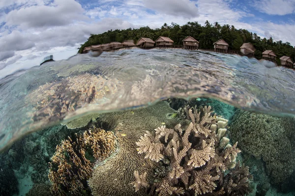
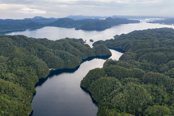
Stock image Waigeo page 2

Wallops Island In The North Atlantic Ocean - Belonging To United States. Described Location Diagram With Yellow Shape Of The Island And Sample Maps Of Its Surroundings
Image, 2.78MB, 3840 × 2160 jpg

Pulau Waleabahi In The Gulf Of Tomini, Belonging To Indonesia, Isolated On A Topographic, OSM Humanitarian Style Map, With Distance Scale
Image, 0.32MB, 2160 × 2160 jpg

Wanqingsha Island In The South China Sea, Belonging To China, Isolated On A Topographic, OSM Humanitarian Style Map, With Distance Scale
Image, 0.96MB, 2160 × 2160 jpg

Pulau Isla De Waigeo In The South Pacific Ocean On A Colored Elevation Map
Image, 2.62MB, 2880 × 1620 jpg

Pulau Wamar In The Arafura Sea, Belonging To Indonesia, Isolated On A Bilevel Elevation Map, With Distance Scale
Image, 0.32MB, 2160 × 2160 jpg

Pulau Warir In The South Pacific Ocean, Belonging To Indonesia, Isolated On A Topographic, OSM Humanitarian Style Map, With Distance Scale
Image, 0.29MB, 2160 × 2160 jpg

Warren Island In The The Coastal Waters Of Southeast Alaska And British Columbia - Belonging To United States. Described Location Diagram With Yellow Shape Of The Island And Sample Maps Of Its Surroundings
Image, 2.25MB, 3840 × 2160 jpg


Emerald Pool Or Tha Pom Klong Song Nam At Krabi Province, Thailand. Amazing Crystal Clear Emerald Canal With Mangrove Forest. Beautiful Nature Landscape. Travel, Holidays, Recreation Concept
Image, 13.61MB, 6240 × 4160 jpg
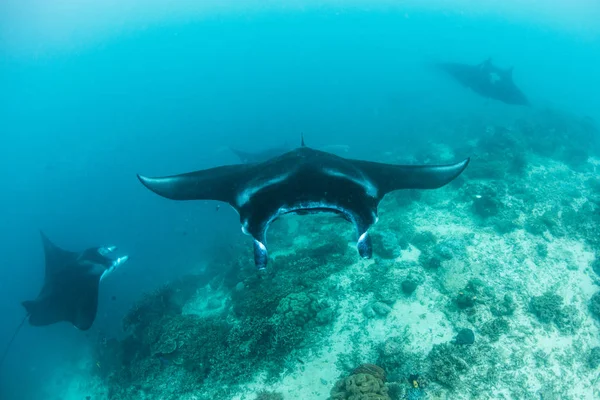
Resident Manta Rays, Manta Alfredi, Swim Over A Cleaning Station In Raja Ampat, Indonesia. Cleaning Stations Are Where Small Fish Remove Parasites From Larger Fish And Mantas Frequent These Sites.
Image, 18.12MB, 5400 × 3600 jpg

Warbah Island In The Persian Gulf, Belonging To Kuwait, Isolated On A Topographic, OSM Humanitarian Style Map, With Distance Scale
Image, 0.23MB, 2160 × 2160 jpg
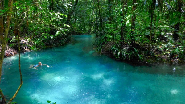
The Kalibiru River, Hidden Blue River In Mayalibit, Waigeo, Raja Ampat, West Papua, Indonesia
Image, 5.45MB, 3968 × 2232 jpg

Pulau Warilau In The Arafura Sea, Belonging To Indonesia, Isolated On A Topographic, OSM Humanitarian Style Map, With Distance Scale
Image, 0.27MB, 2160 × 2160 jpg
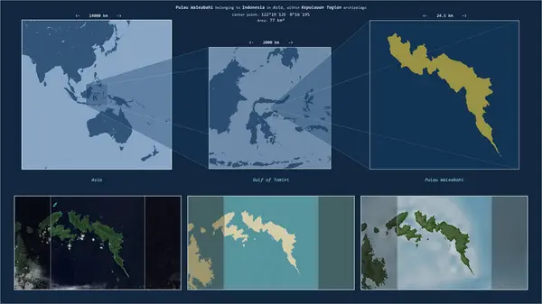
Pulau Waleabahi In The Gulf Of Tomini - Belonging To Indonesia. Described Location Diagram With Yellow Shape Of The Island And Sample Maps Of Its Surroundings
Image, 2.25MB, 3840 × 2160 jpg

Pulau Warir In The South Pacific Ocean - Belonging To Indonesia. Described Location Diagram With Yellow Shape Of The Island And Sample Maps Of Its Surroundings
Image, 2.29MB, 3840 × 2160 jpg

Pulau Waleakodi In The Gulf Of Tomini, Belonging To Indonesia, Isolated On A Bilevel Elevation Map, With Distance Scale
Image, 0.37MB, 2160 × 2160 jpg

Waiheke Island In The South Pacific Ocean, Belonging To New Zealand, Isolated On A Bilevel Elevation Map, With Distance Scale
Image, 0.38MB, 2160 × 2160 jpg

Wando Island In The Japan Sea, Belonging To South Korea, Isolated On A Bilevel Elevation Map, With Distance Scale
Image, 0.52MB, 2160 × 2160 jpg


Wallops Island In The North Atlantic Ocean, Belonging To United States, Isolated On A Topographic, OSM Humanitarian Style Map, With Distance Scale
Image, 0.49MB, 2160 × 2160 jpg

Wando Island In The Japan Sea, Belonging To South Korea, Isolated On A Topographic, OSM Humanitarian Style Map, With Distance Scale
Image, 1.1MB, 2160 × 2160 jpg

Pulau Waleabahi In The Gulf Of Tomini, Belonging To Indonesia, Isolated On A Bilevel Elevation Map, With Distance Scale
Image, 0.33MB, 2160 × 2160 jpg

Pulau Isla De Waigeo In The South Pacific Ocean, Belonging To Indonesia, Isolated On A Bilevel Elevation Map, With Distance Scale
Image, 0.53MB, 2160 × 2160 jpg

Pulau Isla De Waigeo In The South Pacific Ocean On A Topographic, OSM Humanitarian Style Map
Image, 1.02MB, 2880 × 1620 jpg
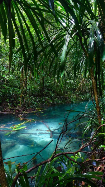
The Kalibiru River, Hidden Blue River In Mayalibit, Waigeo, Raja Ampat, West Papua, Indonesia
Image, 5.44MB, 2232 × 3968 jpg

Waigeou Cuscus Or Waigeou Spotted Cuscus (Spilocuscus Papuensis) Is A Species Of Marsupial In The Family Phalangeridae. It Is Endemic To The Island Of Waigeo In Indonesia.
Image, 29.44MB, 8192 × 5464 jpg


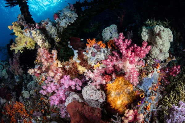
Rugged Limestone Islands Surround A Beautiful, Tropical Lagoon In Raja Ampat, Indonesia. This Remote Region Is Called The "heart Of The Coral Triangle" Due To Its Extraordinary Marine Biodiversity.
Image, 9.87MB, 3600 × 5400 jpg


Pulau Waleakodi In The Gulf Of Tomini, Belonging To Indonesia, Isolated On A Topographic, OSM Humanitarian Style Map, With Distance Scale
Image, 0.4MB, 2160 × 2160 jpg

Pulau Warilau In The Arafura Sea - Belonging To Indonesia. Described Location Diagram With Yellow Shape Of The Island And Sample Maps Of Its Surroundings
Image, 2.25MB, 3840 × 2160 jpg

Pulau Isla De Waigeo In The South Pacific Ocean On A Satellite Image Taken In February 13, 2023
Image, 2.02MB, 2880 × 1620 jpg
Narrow Channels Wind Through Remote Limestone Islands In Raja Ampat, Indonesia. This Biodiverse Region Is Known As The "heart Of The Coral Triangle" Due To Its Amazing Marine Life.
Image, 11.43MB, 5400 × 3597 jpg

Waigeou Cuscus Or Waigeou Spotted Cuscus (Spilocuscus Papuensis) Is A Species Of Marsupial In The Family Phalangeridae. It Is Endemic To The Island Of Waigeo In Indonesia.
Image, 27.96MB, 8192 × 5464 jpg

Warren Island In The The Coastal Waters Of Southeast Alaska And British Columbia, Belonging To United States, Isolated On A Bilevel Elevation Map, With Distance Scale
Image, 0.4MB, 2160 × 2160 jpg

Warri Island In The Gulf Of Guinea - Belonging To Nigeria. Described Location Diagram With Yellow Shape Of The Island And Sample Maps Of Its Surroundings
Image, 2.64MB, 3840 × 2160 jpg

Wanqingsha Island In The South China Sea - Belonging To China. Described Location Diagram With Yellow Shape Of The Island And Sample Maps Of Its Surroundings
Image, 3.25MB, 3840 × 2160 jpg


Wakamatsujima In The Japan Sea, Belonging To Japan, Isolated On A Bilevel Elevation Map, With Distance Scale
Image, 0.39MB, 2160 × 2160 jpg
Previous << Page 2 >> Next