Home
Images
Vectors
Videos
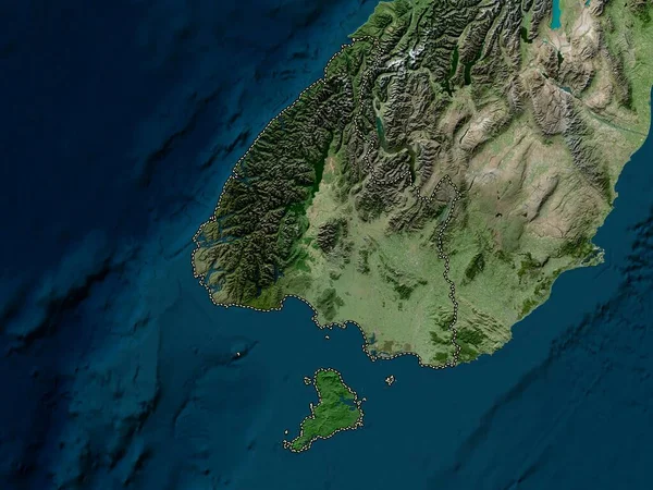
Stock image Clare Island in the North Atlantic Ocean on a satellite image taken in June 2, 2023
Published:
Sep.12, 2024 07:14:15
Author:
zelwanka
Views:
0
Downloads:
0
File type:
image
/
jpg
File size:
4.16 MB
Orginal size:
2880
x
1620
px
Available sizes:
S
(500 x 281)
M
(1000 x 563)
L
(2000 x 1125)
XL
(2880 x 1620)
EL0
(2880 x 1620)
Level:
beginner
Download Image
Image topics:
Shape
Nature
Border
Contour
Earth
Planet
World
Ocean
Science
Europe
Imagery
Outline
Country
Map
Geography
Continent
Ireland
Land
Zoom
Island
Satellite
Region
Territory
Atlas
Irl
Stereographic
North Atlantic Ocean
Clare Island
Similar stock images
Jar Lann Kyun Island In The Andaman Or Burma Sea On A Satellite Image Taken In June 27, 2024
2880 × 1620
Paramushir Island In The Sea Of Okhotsk On A Satellite Image Taken In October 2, 2011
2880 × 1620
Margarita Island In The Caribbean Sea On A Satellite Image Taken In November 7, 2022
2880 × 1620
Nakchamik Island In The Gulf Of Alaska On A Satellite Image Taken In July 3, 2019
2880 × 1620
Santa Maria Island In The North Atlantic Ocean On A Satellite Image Taken In May 12, 2021
2880 × 1620
Isla San Cristobal In The South Pacific Ocean On A Satellite Image Taken In January 8, 2023
2880 × 1620
Southland, Regional Council Of New Zealand. High Resolution Satellite Map
3840 × 2880
Mare Island In The Coral Sea On A Satellite Image Taken In October 13, 2019
2880 × 1620