photo free
Home Images Vectors Videos

Stock image Stereographic

stock image Peru area on the satellite C map in the stereographic projection - raw composition of raster layers with dark glowing outline

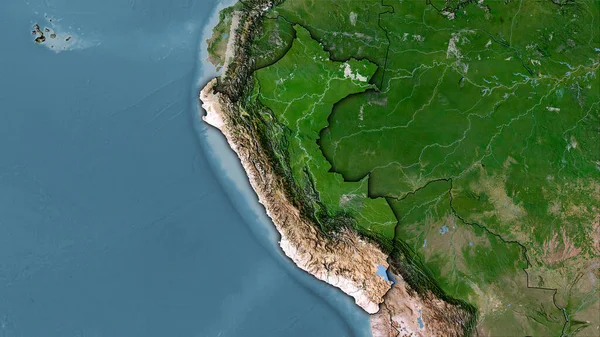
Peru Area On The Satellite C Map In The Stereographic Projection - Raw Composition Of Raster Layers With Dark Glowing Outline

Image, 5.94MB, 2880 × 1620 jpg
stock image Mean temperature of warmest quarter within the New Caledonia area in the stereographic projection with legend - main composition

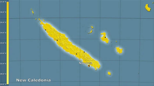
Mean Temperature Of Warmest Quarter Within The New Caledonia Area In The Stereographic Projection With Legend - Main Composition

Image, 1.15MB, 2880 × 1620 jpg
stock image World map in the Braun Stereographic projection centered on 11 East longitude. Mean annual temperature map - raw composite of raster with graticule. 3D illustration

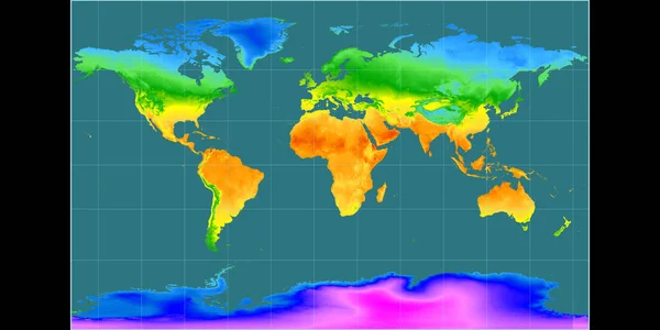
World Map In The Braun Stereographic Projection Centered On 11 East Longitude. Mean Annual Temperature Map - Raw Composite Of Raster With Graticule. 3D Illustration

Image, 3.4MB, 4000 × 2000 jpg
stock image tourist with sleds walks along the blue ice of Lake Baikal. Wide-angle panorama

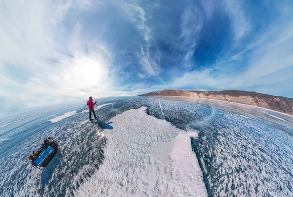
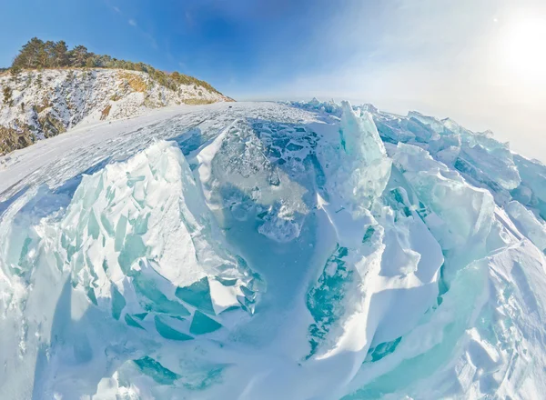
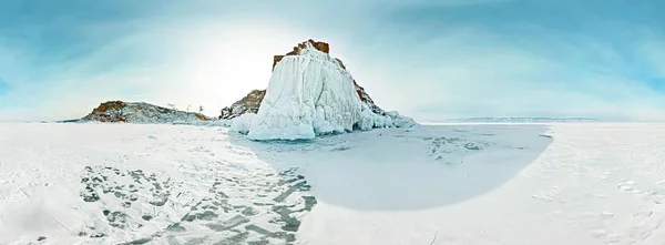
Tourist With Sleds Walks Along The Blue Ice Of Lake Baikal. Wide-angle Panorama

Image, 14.08MB, 9000 × 6089 jpg
stock image Little green planet

Little Green Planet

Image, 20.45MB, 9932 × 4966 jpg
stock image Blue ice sphere covered with cracks on a blue background, the st

Blue Ice Sphere Covered With Cracks On A Blue Background, The St

Image, 13.47MB, 8000 × 8000 jpg
stock image 360 panorama blue ice of Lake Baikal covered with cracks, cloudy

360 Panorama Blue Ice Of Lake Baikal Covered With Cracks, Cloudy

Image, 17.58MB, 8000 × 8000 jpg
stock image Blue ice hummocks Baikal stereographic panorama, Listvyanka

Blue Ice Hummocks Baikal Stereographic Panorama, Listvyanka

Image, 9.65MB, 12000 × 8802 jpg
stock image man in red stands under a waterfall on a black rock in the mountains on a cloudy rainy day. Tiny little planet 360

Man In Red Stands Under A Waterfall On A Black Rock In The Mountains On A Cloudy Rainy Day. Tiny Little Planet 360

Image, 10.1MB, 8000 × 8000 jpg
stock image Tocantins, state of Brazil. Elevation map colored in wiki style with lakes and rivers. Locations of major cities of the region. Corner auxiliary location maps

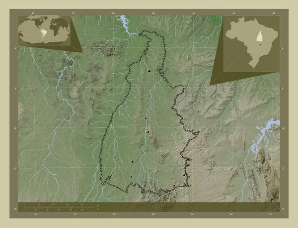
Tocantins, State Of Brazil. Elevation Map Colored In Wiki Style With Lakes And Rivers. Locations Of Major Cities Of The Region. Corner Auxiliary Location Maps

Image, 10.37MB, 4930 × 3770 jpg
stock image Suspension bridge crossing - stereoscopic 3-d image

Suspension Bridge Crossing - Stereoscopic 3-d Image

Image, 6.5MB, 4090 × 2722 jpg
stock image Blue ice of Lake Baikal covered with cracks, cloudy weather at s

Blue Ice Of Lake Baikal Covered With Cracks, Cloudy Weather At S

Image, 41.39MB, 10000 × 5578 jpg
stock image Stretched wide-angle view of the top of aerial photography snowy

Stretched Wide-angle View Of The Top Of Aerial Photography Snowy

Image, 20.51MB, 10019 × 7207 jpg
stock image Stereographic panorama of Lake Baikal from the beach rocks in projection a small planet

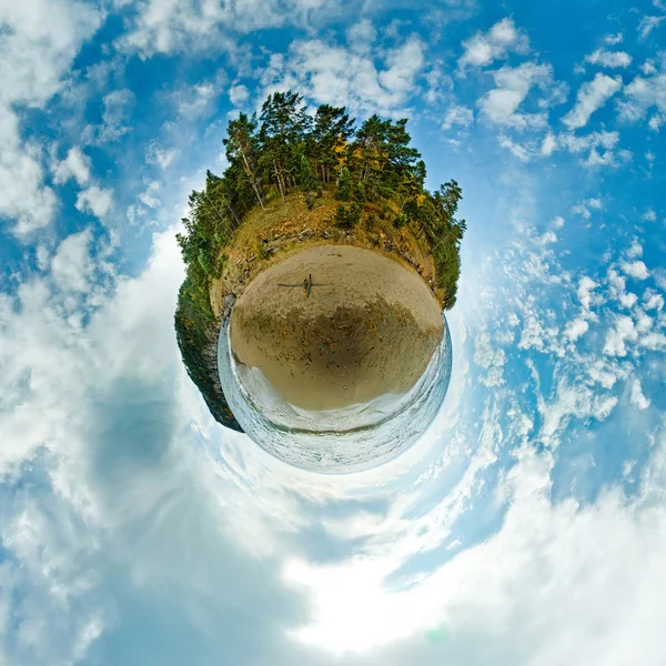
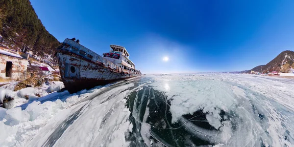
Stereographic Panorama Of Lake Baikal From The Beach Rocks In Projection A Small Planet

Image, 15.15MB, 10000 × 10000 jpg
stock image Tajikistan area on the satellite B map in the stereographic projection - raw composition of raster layers with light glowing outline

Tajikistan Area On The Satellite B Map In The Stereographic Projection - Raw Composition Of Raster Layers With Light Glowing Outline

Image, 6.35MB, 2880 × 1620 jpg
stock image Tajikistan area on the topographic relief map in the stereographic projection - raw composition of raster layers with light glowing outline

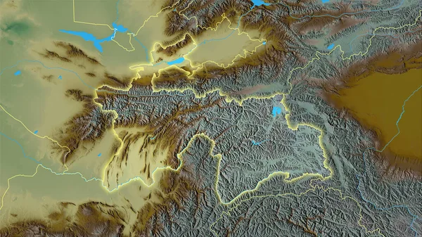
Tajikistan Area On The Topographic Relief Map In The Stereographic Projection - Raw Composition Of Raster Layers With Light Glowing Outline

Image, 7.08MB, 2880 × 1620 jpg
stock image Enlarged area of South Korea surrounded by a circle on the background of its neighborhood. Color physical map

Enlarged Area Of South Korea Surrounded By A Circle On The Background Of Its Neighborhood. Color Physical Map

Image, 2.85MB, 2880 × 1620 jpg
stock image Spain area on the annual precipitation map in the stereographic projection - raw composition of raster layers with dark glowing outline

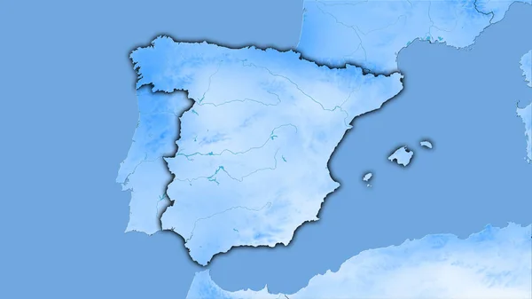
Spain Area On The Annual Precipitation Map In The Stereographic Projection - Raw Composition Of Raster Layers With Dark Glowing Outline

Image, 1.67MB, 2880 × 1620 jpg
stock image Top of the mountain overlooking the lake zamersshee, backpack an

Top Of The Mountain Overlooking The Lake Zamersshee, Backpack An

Image, 12.17MB, 10167 × 6255 jpg
stock image New Caledonia area on the satellite A map in the stereographic projection - raw composition of raster layers with light glowing outline

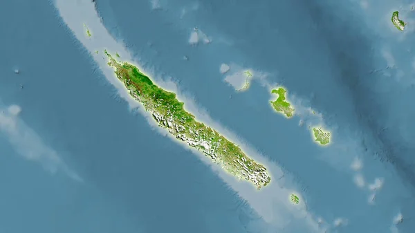
New Caledonia Area On The Satellite A Map In The Stereographic Projection - Raw Composition Of Raster Layers With Light Glowing Outline

Image, 2.19MB, 2880 × 1620 jpg
stock image Ethiopia area on the satellite A map in the stereographic projection - raw composition of raster layers

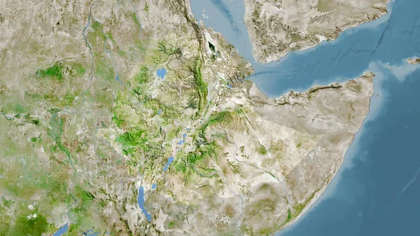
Ethiopia Area On The Satellite A Map In The Stereographic Projection - Raw Composition Of Raster Layers

Image, 6.57MB, 2880 × 1620 jpg
stock image World map in the Gall Stereographic projection centered on 11 East longitude. Colored shader, elevation map - raw composite of raster with graticule. 3D illustration

World Map In The Gall Stereographic Projection Centered On 11 East Longitude. Colored Shader, Elevation Map - Raw Composite Of Raster With Graticule. 3D Illustration

Image, 7.47MB, 4000 × 2000 jpg
stock image Spain area on the satellite C map in the stereographic projection - raw composition of raster layers

Spain Area On The Satellite C Map In The Stereographic Projection - Raw Composition Of Raster Layers

Image, 5.47MB, 2880 × 1620 jpg
stock image Malawi area on the satellite D map in the stereographic projection - main composition

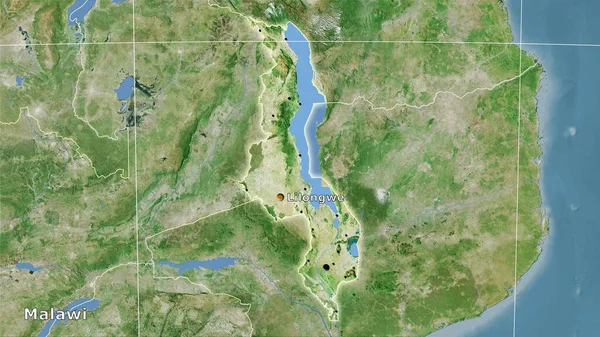
Malawi Area On The Satellite D Map In The Stereographic Projection - Main Composition

Image, 6.84MB, 2880 × 1620 jpg
stock image Romania area on the satellite A map in the stereographic projection - main composition

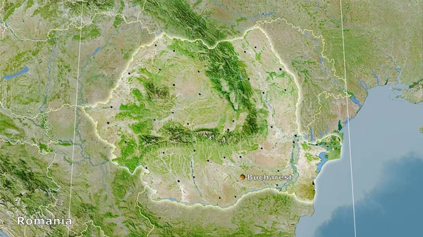
Romania Area On The Satellite A Map In The Stereographic Projection - Main Composition

Image, 7.64MB, 2880 × 1620 jpg
stock image Kasserine, governorate of Tunisia. Open Street Map

Kasserine, Governorate Of Tunisia. Open Street Map

Image, 3.87MB, 3840 × 2880 jpg
stock image Mahdia, governorate of Tunisia. Elevation map colored in wiki style with lakes and rivers

Mahdia, Governorate Of Tunisia. Elevation Map Colored In Wiki Style With Lakes And Rivers

Image, 5.27MB, 3840 × 2880 jpg
stock image Jendouba, governorate of Tunisia. Colored elevation map with lakes and rivers

Jendouba, Governorate Of Tunisia. Colored Elevation Map With Lakes And Rivers

Image, 6.37MB, 3840 × 2880 jpg
stock image Kherson, region of Ukraine. Low resolution satellite map

Kherson, Region Of Ukraine. Low Resolution Satellite Map

Image, 7.74MB, 3840 × 2880 jpg
stock image Kakheti, region of Georgia. High resolution satellite map

Kakheti, Region Of Georgia. High Resolution Satellite Map

Image, 10.54MB, 3840 × 2880 jpg
stock image Totonicapan, department of Guatemala. High resolution satellite map

Totonicapan, Department Of Guatemala. High Resolution Satellite Map

Image, 9.83MB, 3840 × 2880 jpg
stock image Heilongjiang, province of China. Low resolution satellite map. Corner auxiliary location maps

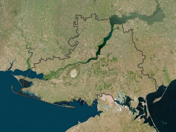
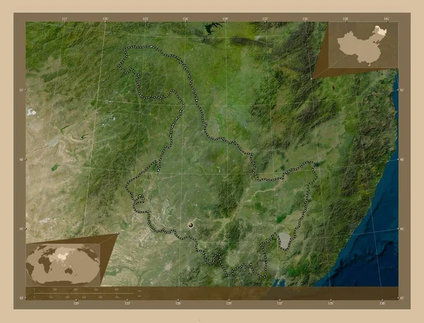
Heilongjiang, Province Of China. Low Resolution Satellite Map. Corner Auxiliary Location Maps

Image, 11.56MB, 4930 × 3770 jpg
stock image Kampot, province of Cambodia. Elevation map colored in sepia tones with lakes and rivers. Corner auxiliary location maps

Kampot, Province Of Cambodia. Elevation Map Colored In Sepia Tones With Lakes And Rivers. Corner Auxiliary Location Maps

Image, 7.41MB, 4930 × 3770 jpg
stock image Pozesko-Slavonska, county of Croatia. Colored elevation map with lakes and rivers. Corner auxiliary location maps

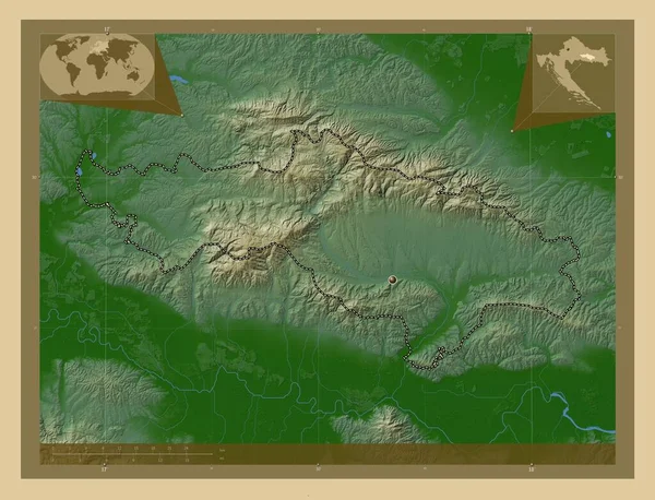
Pozesko-Slavonska, County Of Croatia. Colored Elevation Map With Lakes And Rivers. Corner Auxiliary Location Maps

Image, 9.46MB, 4930 × 3770 jpg
stock image Chiapas, state of Mexico. Elevation map colored in wiki style with lakes and rivers. Locations and names of major cities of the region. Corner auxiliary location maps

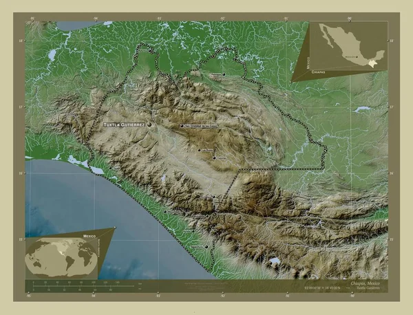
Chiapas, State Of Mexico. Elevation Map Colored In Wiki Style With Lakes And Rivers. Locations And Names Of Major Cities Of The Region. Corner Auxiliary Location Maps

Image, 10.96MB, 4930 × 3770 jpg
stock image 3D anaglyph of empty tunnel

3D Anaglyph Of Empty Tunnel

Image, 3.17MB, 3921 × 2665 jpg
stock image Western Highlands, province of Papua New Guinea. Elevation map colored in wiki style with lakes and rivers. Locations and names of major cities of the region. Corner auxiliary location maps

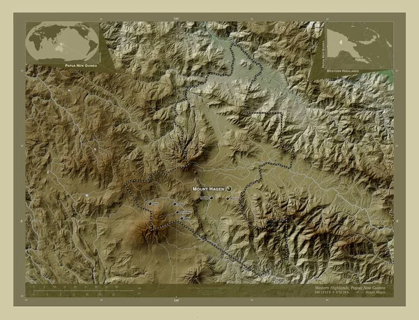
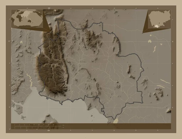
Western Highlands, Province Of Papua New Guinea. Elevation Map Colored In Wiki Style With Lakes And Rivers. Locations And Names Of Major Cities Of The Region. Corner Auxiliary Location Maps

Image, 11.85MB, 4930 × 3770 jpg
stock image World map in the Gall Stereographic projection centered on 11 East longitude. Main physiographic landscape features - raw composite of raster with graticule. 3D illustration

World Map In The Gall Stereographic Projection Centered On 11 East Longitude. Main Physiographic Landscape Features - Raw Composite Of Raster With Graticule. 3D Illustration

Image, 7.6MB, 4000 × 2000 jpg
stock image Aerial view of Wallingford, a historic market town and civil parish located between Oxford and Reading on the River Thames in England, UK

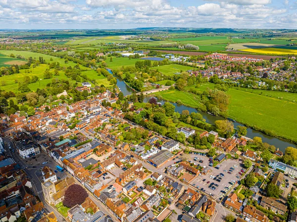
Aerial View Of Wallingford, A Historic Market Town And Civil Parish Located Between Oxford And Reading On The River Thames In England, UK

Image, 13.3MB, 5272 × 3948 jpg
stock image Taiwan area on the satellite B map in the stereographic projection - raw composition of raster layers

Taiwan Area On The Satellite B Map In The Stereographic Projection - Raw Composition Of Raster Layers

Image, 3.08MB, 2880 × 1620 jpg
stock image Borski, district of Serbia. Grayscale elevation map with lakes and rivers

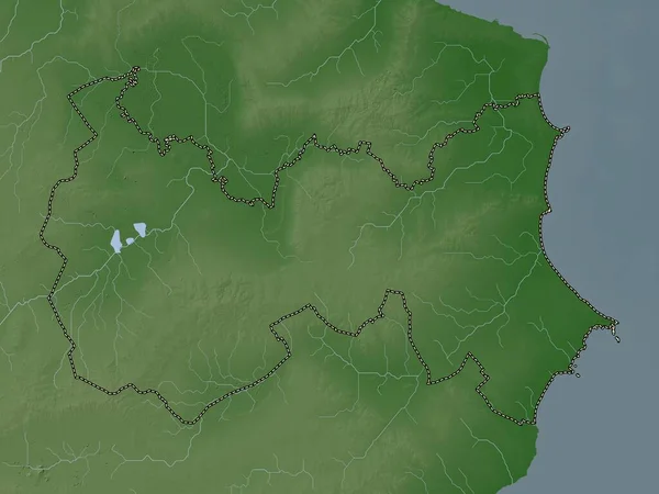
Borski, District Of Serbia. Grayscale Elevation Map With Lakes And Rivers

Image, 6.34MB, 3840 × 2880 jpg
stock image Indian tectonic plate on the Wiki style elevation map in the Gall Stereographic projection centered meridionally. Distribution of known volcanoes

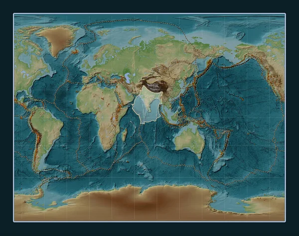
Indian Tectonic Plate On The Wiki Style Elevation Map In The Gall Stereographic Projection Centered Meridionally. Distribution Of Known Volcanoes

Image, 13.86MB, 4800 × 3792 jpg
stock vector Angle 360 degrees sign icon. Geometry math symbol

Angle 360 Degrees Sign Icon. Geometry Math Symbol

Vector, 1.36MB, 4167 × 4167 eps
stock image Colombia area on the satellite D map in the stereographic projection - raw composition of raster layers with light glowing outline

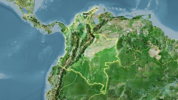
Colombia Area On The Satellite D Map In The Stereographic Projection - Raw Composition Of Raster Layers With Light Glowing Outline

Image, 6.11MB, 2880 × 1620 jpg
stock image Sweden area on the topographic relief map in the stereographic projection - raw composition of raster layers with light glowing outline

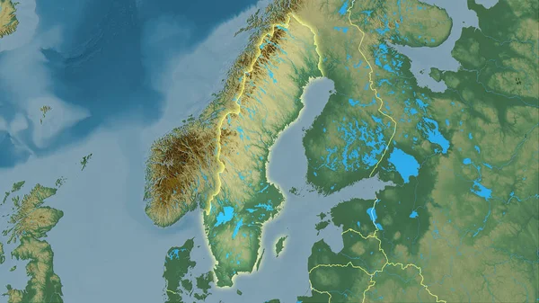
Sweden Area On The Topographic Relief Map In The Stereographic Projection - Raw Composition Of Raster Layers With Light Glowing Outline

Image, 5.03MB, 2880 × 1620 jpg
stock image Cylindrical Panorama 360 Buddhist stupa of enlightenment Ogoy on

Cylindrical Panorama 360 Buddhist Stupa Of Enlightenment Ogoy On

Image, 16.18MB, 12000 × 4444 jpg
stock image Double sphere sandy beach and the ice of Lake Baikal. Spherical

Double Sphere Sandy Beach And The Ice Of Lake Baikal. Spherical

Image, 16.83MB, 10000 × 7490 jpg
stock image Cylindrical panorama Cape shaman on the island of Olkhon, Lake B

Cylindrical Panorama Cape Shaman On The Island Of Olkhon, Lake B

Image, 6.74MB, 10000 × 3690 jpg
stock image Old rusty ship on the coast of Lake Baikal among ice. Wide Panor

Old Rusty Ship On The Coast Of Lake Baikal Among Ice. Wide Panor

Image, 8.62MB, 9840 × 4951 jpg
stock image Shape of a Pale colored elevation map with lakes and rivers of the Puerto Rico - USA, with distance scale and map border coordinates, isolated on black

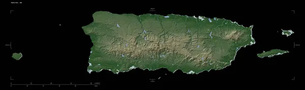
Shape Of A Pale Colored Elevation Map With Lakes And Rivers Of The Puerto Rico - USA, With Distance Scale And Map Border Coordinates, Isolated On Black

Image, 2.32MB, 3883 × 1158 jpg
Page 1 >> Next