Home
Images
Vectors
Videos
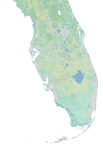
Stock image High resolution topographic map of southern Florida
Published:
Feb.18, 2021 07:37:02
Author:
intrepix
Views:
10
Downloads:
1
File type:
image
/
jpg
File size:
1.92 MB
Orginal size:
4960
x
7015
px
Available sizes:
S
(354 x 500)
M
(707 x 1000)
L
(1414 x 2000)
XL
(4960 x 7015)
EL0
(4960 x 7015)
Level:
beginner
Download Image
Image topics:
Background
Colored
Illustration
Isolated
Shape
Water
River
Physical
Earth
Us
Usa
Surface
Relief
Elevation
Map
Cartography
Geography
Land
State
Chart
Topography
Terrain
America
Places
Territory
Atlas
Florida
Drainage
Regional
Rivers
Shaded
Topographic
Populated
Topographical
High Resolution
United States
High Detail
Physical Map
Hill Shade
Southern Florida
Base Map
Similar stock images
Shape Of Tete, Province Of Mozambique, With Its Capital Isolated On A Solid Color Background. Satellite Imagery. 3D Rendering
3836 × 2918
Map Of Scandinavia - Norway, Sweden, Finland And Denmark
5000 × 7000
Liberia Area On The Annual Temperature Map In The Stereographic Projection - Main Composition
2880 × 1620
Nicaragua Area On The Annual Precipitation Map In The Stereographic Projection - Main Composition
2880 × 1620
Map Of Scandinavia - Norway
5000 × 7000
Mean Diurnal Temperature Variation Within The Lebanon Area In The Stereographic Projection With Legend - Main Composition
2880 × 1620
Precipitation Of Driest Month Within The Brazil Area In The Stereographic Projection With Legend - Raw Composition Of Raster Layers
2880 × 1620
Precipitation Of Wettest Month Within The Brazil Area In The Stereographic Projection With Legend - Raw Composition Of Raster Layers
2880 × 1620