Home
Images
Vectors
Videos
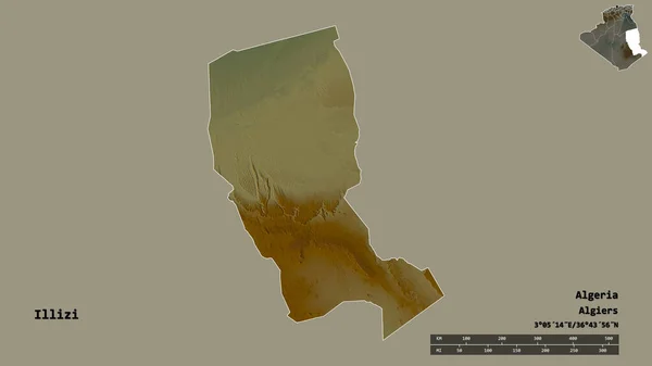
Stock image Shape of Illizi, province of Algeria, with its capital isolated on solid background. Distance scale, region preview and labels. Topographic relief map. 3D rendering
Published:
Aug.18, 2020 13:42:13
Author:
Yarr65
Views:
1
Downloads:
0
File type:
image
/
jpg
File size:
1.08 MB
Orginal size:
2880
x
1620
px
Available sizes:
S
(500 x 281)
M
(1000 x 563)
L
(2000 x 1125)
XL
(2880 x 1620)
EL0
(2880 x 1620)
Level:
bronze
Download Image
Image topics:
View
Travel
Nature
Sea
Landscape
Earth
Planet
World
Ocean
Science
Relief
Capital
Globe
Profile
Country
Map
Cartography
Geography
Africa
Algeria
Continent
Land
Zoom
Region
Territory
Atlas
Province
Overlay
Algiers
3d Rendering
Subregion
Polignac
Dza
Administrative Division
Illizi
Fort Polignac
Ilizi
Similar stock images
Shape Of Sidi Bel Abbes, Province Of Algeria, With Its Capital Isolated On Solid Background. Distance Scale, Region Preview And Labels. Topographic Relief Map. 3D Rendering
2880 × 1620
Desaturated Shape Of Algeria With Its Capital, Main Regional Division And The Separated Mascara Area. Labels. Topographic Relief Map. 3D Rendering
2880 × 1620
Shape Of Adrar, Province Of Algeria, With Its Capital Isolated On Solid Background. Distance Scale, Region Preview And Labels. Topographic Relief Map. 3D Rendering
2880 × 1620
Desaturated Shape Of Algeria With Its Capital, Main Regional Division And The Separated Ouargla Area. Labels. Topographic Relief Map. 3D Rendering
2880 × 1620
Shape Of M'Sila, Province Of Algeria, With Its Capital Isolated On Solid Background. Distance Scale, Region Preview And Labels. Topographic Relief Map. 3D Rendering
2880 × 1620
Desaturated Shape Of Algeria With Its Capital, Main Regional Division And The Separated Ghardaia Area. Labels. Satellite Imagery. 3D Rendering
2880 × 1620
Desaturated Shape Of Algeria With Its Capital, Main Regional Division And The Separated Khenchela Area. Labels. Topographic Relief Map. 3D Rendering
2880 × 1620
Desaturated Shape Of Algeria With Its Capital, Main Regional Division And The Separated Saida Area. Labels. Topographic Relief Map. 3D Rendering
2880 × 1620