
Stock image Administrative Division
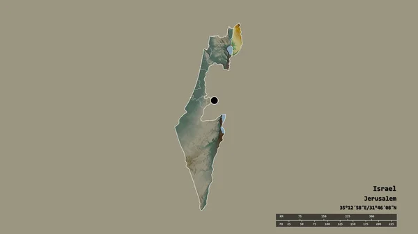
Desaturated Shape Of Israel With Its Capital, Main Regional Division And The Separated Golan Area. Labels. Topographic Relief Map. 3D Rendering
Image, 0.4MB, 2880 × 1620 jpg

Area Of Utah, State Of Mainland United States, Isolated On A Solid Background In A Georeferenced Bounding Box. Labels. Satellite Imagery. 3D Rendering
Image, 2.06MB, 2880 × 1620 jpg
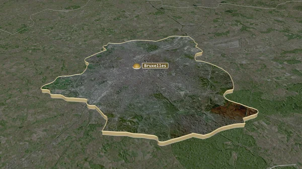
Zoom In On Bruxelles (capital Region Of Belgium) Extruded. Oblique Perspective. Satellite Imagery. 3D Rendering
Image, 3.54MB, 3840 × 2160 jpg
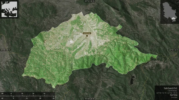
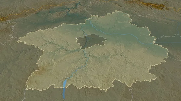
Jablanicki , District Of Serbia. Satellite Imagery. Shape Presented Against Its Country Area With Informative Overlays. 3D Rendering
Image, 6.26MB, 2880 × 1620 jpg

Santa Catarina, State Of Brazil. Satellite Imagery. Shape Presented Against Its Country Area With Informative Overlays. 3D Rendering
Image, 5.33MB, 2880 × 1620 jpg
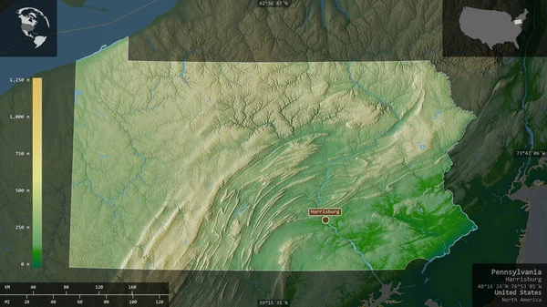
Pennsylvania, State Of United States. Colored Shader Data With Lakes And Rivers. Shape Presented Against Its Country Area With Informative Overlays. 3D Rendering
Image, 5.34MB, 2880 × 1620 jpg

Shape Of Wyoming, State Of Mainland United States, With Its Capital Isolated On White Background. Composition Of Patterned Textures. 3D Rendering
Image, 16.06MB, 3836 × 3193 jpg
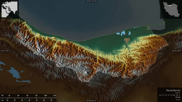
Mazandaran, Province Of Iran. Colored Relief With Lakes And Rivers. Shape Presented Against Its Country Area With Informative Overlays. 3D Rendering
Image, 3.6MB, 2880 × 1620 jpg
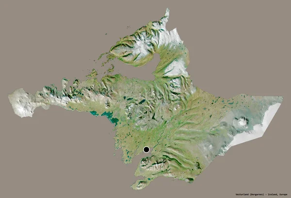
Shape Of Vesturland, Region Of Iceland, With Its Capital Isolated On A Solid Color Background. Satellite Imagery. 3D Rendering
Image, 5.19MB, 3836 × 2617 jpg
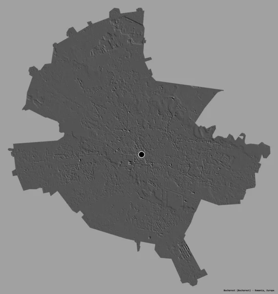
Shape Of Bucharest, Municipality Of Romania, With Its Capital Isolated On A Solid Color Background. Bilevel Elevation Map. 3D Rendering
Image, 2.2MB, 3643 × 3836 jpg

Transcarpathia, Region Of Ukraine. Satellite Imagery. Shape Presented Against Its Country Area With Informative Overlays. 3D Rendering
Image, 5.91MB, 2880 × 1620 jpg
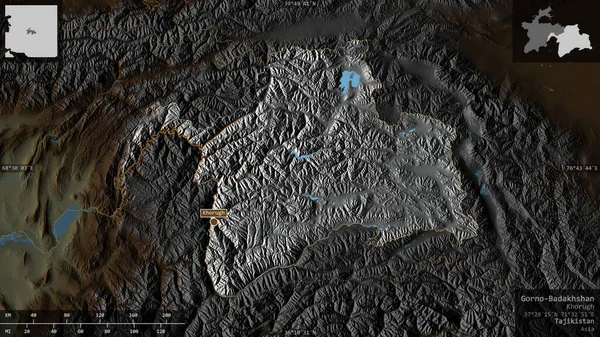
Gorno-Badakhshan, Region Of Tajikistan. Colored Relief With Lakes And Rivers. Shape Presented Against Its Country Area With Informative Overlays. 3D Rendering
Image, 5.27MB, 2880 × 1620 jpg
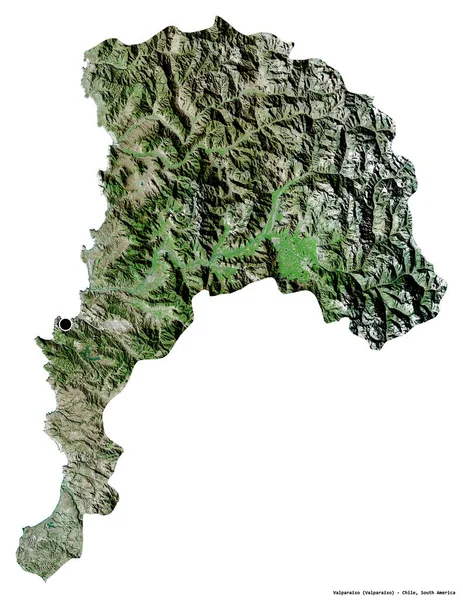
Shape Of Valparaiso, Region Of Chile, With Its Capital Isolated On White Background. Satellite Imagery. 3D Rendering
Image, 8.19MB, 2965 × 3836 jpg
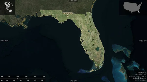
Florida, State Of United States. Satellite Imagery. Shape Presented Against Its Country Area With Informative Overlays. 3D Rendering
Image, 2.96MB, 2880 × 1620 jpg
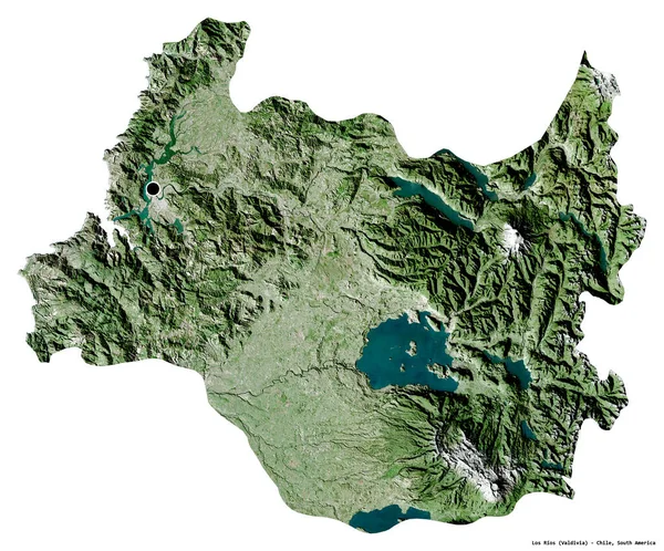
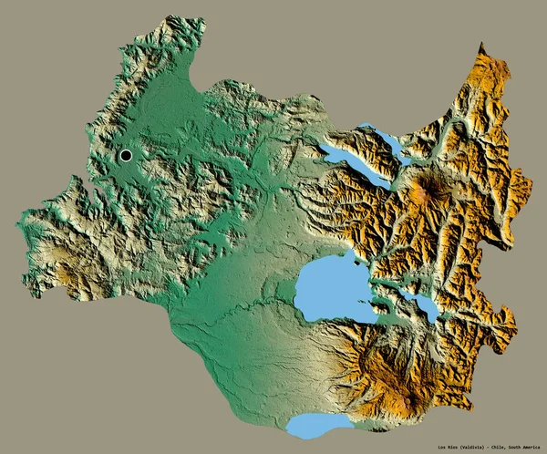
Shape Of Los Rios, Region Of Chile, With Its Capital Isolated On White Background. Satellite Imagery. 3D Rendering
Image, 12.52MB, 3836 × 3185 jpg
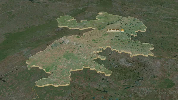
Zoom In On Chelyabinsk (region Of Russia) Extruded. Oblique Perspective. Satellite Imagery. 3D Rendering
Image, 3.81MB, 3840 × 2160 jpg

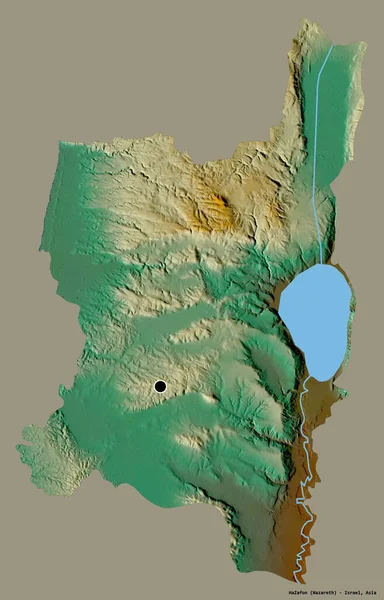
Shape Of HaZafon, District Of Israel, With Its Capital Isolated On Solid Background. Distance Scale, Region Preview And Labels. Topographic Relief Map. 3D Rendering
Image, 1.07MB, 2880 × 1620 jpg

Krasnoyarsk, Territory Of Russia. Grayscaled Map With Lakes And Rivers. Shape Presented Against Its Country Area With Informative Overlays. 3D Rendering
Image, 2.33MB, 2880 × 1620 jpg
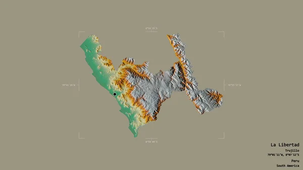
Area Of La Libertad, Region Of Peru, Isolated On A Solid Background In A Georeferenced Bounding Box. Labels. Topographic Relief Map. 3D Rendering
Image, 1.08MB, 2880 × 1620 jpg

Tambov - Region Of Russia Zoomed And Highlighted. Satellite Imagery. 3D Rendering
Image, 5.37MB, 2880 × 1620 jpg

Odessa, Region Of Ukraine. Satellite Imagery. Shape Presented Against Its Country Area With Informative Overlays. 3D Rendering
Image, 5.69MB, 2880 × 1620 jpg

Los Lagos, Region Of Chile. Satellite Imagery. Shape Presented Against Its Country Area With Informative Overlays. 3D Rendering
Image, 3.7MB, 2880 × 1620 jpg
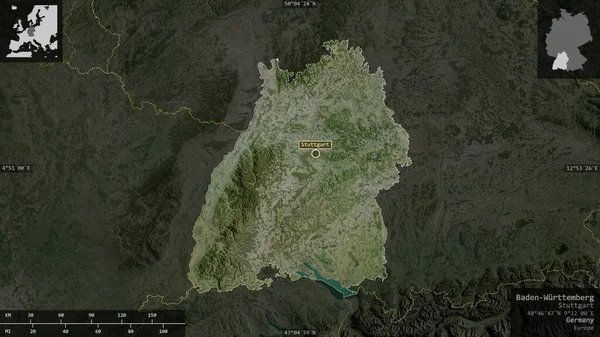
Baden-Wurttemberg , State Of Germany. Satellite Imagery. Shape Presented Against Its Country Area With Informative Overlays. 3D Rendering
Image, 5.95MB, 2880 × 1620 jpg
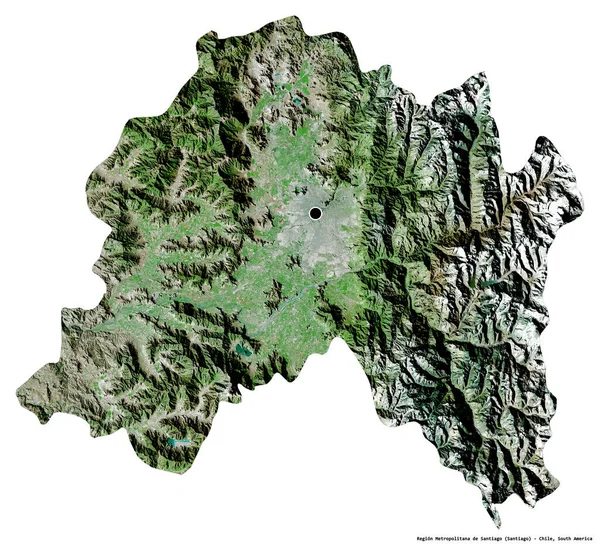
Shape Of Region Metropolitana De Santiago, Region Of Chile, With Its Capital Isolated On White Background. Satellite Imagery. 3D Rendering
Image, 12.7MB, 3836 × 3491 jpg

Area Of California, State Of Mainland United States, Isolated On A Solid Background In A Georeferenced Bounding Box. Labels. Satellite Imagery. 3D Rendering
Image, 1.21MB, 2880 × 1620 jpg
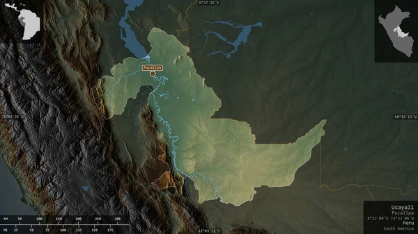
Ucayali, Region Of Peru. Colored Relief With Lakes And Rivers. Shape Presented Against Its Country Area With Informative Overlays. 3D Rendering
Image, 5.09MB, 2880 × 1620 jpg
Shape Of HaZafon, District Of Israel, With Its Capital Isolated On A Solid Color Background. Topographic Relief Map. 3D Rendering
Image, 4.72MB, 2461 × 3836 jpg

Salaj, County Of Romania. Satellite Imagery. Shape Presented Against Its Country Area With Informative Overlays. 3D Rendering
Image, 6.2MB, 2880 × 1620 jpg
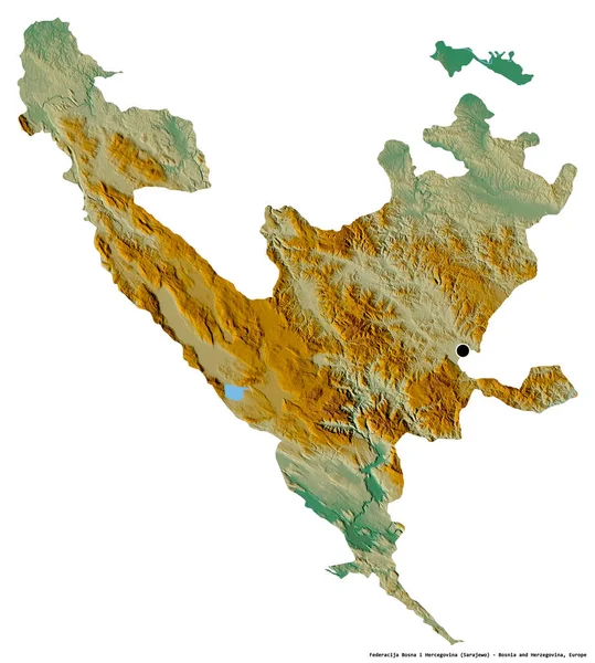
Shape Of Federacija Bosna I Hercegovina, Entity Of Bosnia And Herzegovina, With Its Capital Isolated On White Background. Topographic Relief Map. 3D Rendering
Image, 6.39MB, 3447 × 3836 jpg
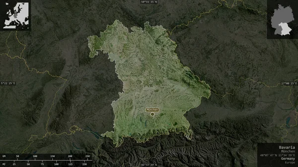
Bavaria, State Of Germany. Satellite Imagery. Shape Presented Against Its Country Area With Informative Overlays. 3D Rendering
Image, 6.17MB, 2880 × 1620 jpg

Desaturated Shape Of Romania With Its Capital, Main Regional Division And The Separated Harghita Area. Labels. Topographic Relief Map. 3D Rendering
Image, 1.74MB, 2880 × 1620 jpg

Newfoundland And Labrador, Province Of Canada. Colored Shader Data With Lakes And Rivers. Shape Presented Against Its Country Area With Informative Overlays. 3D Rendering
Image, 3.24MB, 2880 × 1620 jpg
Shape Of Los Rios, Region Of Chile, With Its Capital Isolated On A Solid Color Background. Topographic Relief Map. 3D Rendering
Image, 10.79MB, 3836 × 3185 jpg

Shape Of Tigray, State Of Ethiopia, With Its Capital Isolated On A Solid Color Background. Composition Of Patterned Textures. 3D Rendering
Image, 9MB, 3836 × 2930 jpg

Zoom In On Okinawa (prefecture Of Japan) Extruded. Oblique Perspective. Satellite Imagery. 3D Rendering
Image, 0.81MB, 3840 × 2160 jpg
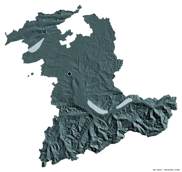
Shape Of Bern, Canton Of Switzerland, With Its Capital Isolated On White Background. Colored Elevation Map. 3D Rendering
Image, 4.12MB, 3836 × 3631 jpg
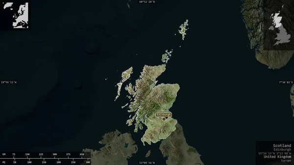
Scotland, Region Of United Kingdom. Satellite Imagery. Shape Presented Against Its Country Area With Informative Overlays. 3D Rendering
Image, 2.02MB, 2880 × 1620 jpg
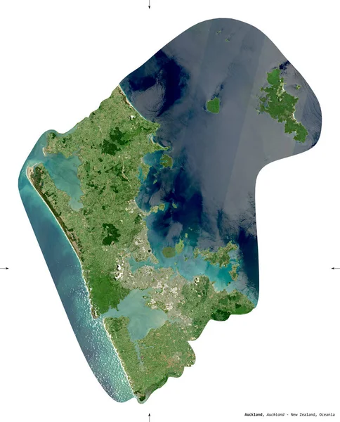
Auckland, Regional Council Of New Zealand. Sentinel-2 Satellite Imagery. Shape Isolated On White. Description, Location Of The Capital. Contains Modified Copernicus Sentinel Data
Image, 7.12MB, 2840 × 3519 jpg
Zoom In On Stredocesky (region Of Czech Republic) Outlined. Oblique Perspective. Topographic Relief Map With Surface Waters. 3D Rendering
Image, 2.42MB, 3840 × 2160 jpg

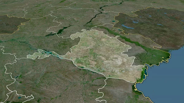
Zoom In On Tver' (region Of Russia) Extruded. Oblique Perspective. Satellite Imagery. 3D Rendering
Image, 3.52MB, 3840 × 2160 jpg

Northern Ireland - Region Of United Kingdom Zoomed And Highlighted. Colored And Bumped Map Of The Administrative Division. 3D Rendering
Image, 2.49MB, 2880 × 1620 jpg

Shape Of Bio-Bio, Region Of Chile, With Its Capital Isolated On White Background. Satellite Imagery. 3D Rendering
Image, 12.43MB, 3460 × 3836 jpg

Zoom In On Magallanes Y Antartica Chilena (region Of Chile) Extruded. Oblique Perspective. Satellite Imagery. 3D Rendering
Image, 2.55MB, 3840 × 2160 jpg

Sikkim, State Of India. Sentinel-2 Satellite Imagery. Shape Isolated On Solid Background With Informative Overlays. Contains Modified Copernicus Sentinel Data
Image, 5.82MB, 3144 × 3180 jpg

Shape Of Austria Separated By The Desaturation Of Neighboring Areas. Topographic Relief Map. 3D Rendering
Image, 7.57MB, 3000 × 2000 jpg
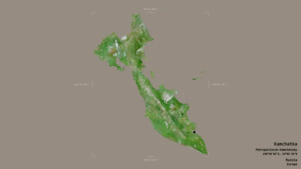
Area Of Kamchatka, Territory Of Russia, Isolated On A Solid Background In A Georeferenced Bounding Box. Labels. Satellite Imagery. 3D Rendering
Image, 0.94MB, 2880 × 1620 jpg
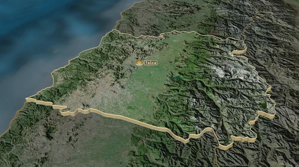
Zoom In On Maule (region Of Chile) Extruded. Oblique Perspective. Satellite Imagery. 3D Rendering
Image, 4.37MB, 3840 × 2160 jpg

Idaho, State Of United States. Colored Shader Data With Lakes And Rivers. Shape Outlined Against Its Country Area. 3D Rendering
Image, 6.82MB, 2880 × 1620 jpg
Kalmyk - Republic Of Russia Zoomed And Highlighted. Satellite Imagery. 3D Rendering
Image, 4.84MB, 2880 × 1620 jpg
Page 1 >> Next